Maps of Jülich

IVLIACI OBSIDIO Ao. MDCXI.
[Amsterdam : Joan Blaeu]
Iülich.
Mollova mapová sbírka Bodenehr, Gabriel Bodenehr, Gabriel
Wahrer Grundtriss der Statt und Vestung Gülich
Mollova mapová sbírka Merian, Matthaeus Merian, Matthäus
GVLICH : [fortification plan]
[Amsterdam : Joan Blaeu]
Meßtischblatt 2904 : Jülich, 1934
1 : 250000 Jülich. - Hrsg. 1894, bericht. 1934. - 1:25000. - [Berlin]: Reichsamt für Landesaufnahme, 1934. - 1 Kt.
Meßtischblatt 2904 : Jülich, 1926
1 : 250000 Jülich. - Aufn. 1893, bericht. 1909, Nachtr. 1926. - 1:25000. - [Berlin]: Reichsamt für Landesaufnahme, 1926. - 1 Kt.
Meßtischblatt 2904 : Jülich, 1894
1 : 250000 Jülich. - Aufn. 1893, hrsg. 1894. - 1:25000. - [Berlin]: Reichsamt für Landesaufnahme, 1894. - 1 Kt.
Meßtischblatt 2904 : Linnich, 1895
1 : 250000 Linnich. - Aufn. 1893. - 1:25000. - [Berlin]: Reichsamt für Landesaufnahme, 1895. - 1 Kt.
Meßtischblatt 5104 : Düren, 1940
1 : 250000 Düren. - Aufn. 1893, hrsg. 1895, bericht. 1938, Ausg. 1940, Nur für d. Dienstgebrauch!. - 1:25000. - [Berlin]: Reichsamt für Landesaufnahme, 1940. - 1 Kt.
Bl. 36 Herzogenrath, 1904, uit: Atlas A.N.W.B.
1 : 200000 titelvariant: Atlas van Nederland van den A.N.W.B. Toeristenbond voor Nederland; Wielrijders-atlas van Nederland; Annotatie: Titel op bladwijzer: Atlas van Nederland van den A.N.W.B. Toeristenbond voor Nederland; Titel op legendablad: Wielrijders-atlas van Nederland; Voor aanwezige bladen zie overzichtsblad; Annotatie geografische gegevens: De serie bestaat uit 36 bladen ANWB ['s-Gravenhage : A.N.W.B.]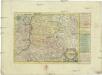
Das Herzogthum Limburg
1 : 380000 Limbursko Schreiber, Johann Georg bey Joh. Georg. Schreibern
X ; 2.M., uit: Carte chorographique des Pays-Bas Autrichiens / ... par le Comte de Ferraris ; gravée par L.A. Dupuis
1 : 86400 Annotatie: Bladen linksboven genummerd met Romeinse cijfers, rechtsboven met een cijfer en een letter; Met opdracht aan keizer Joseph II (bl.XVI); Met plattegrond van Brussel (bl. XXI), overzichtskaart (bl. XXII) en bladwijzer (bl. XXIII); Annotatie geografische gegevens: Schaalstokken: Echelle de Toises ou de Lieues communes de France; Echelle de Verges ou de Lieues de Brabant; Echelle de Milles d'Allemagne (bl. XVII); Echelle de Mètres; In de hoeken lengte- en breedtematen T.M.e en T.P.e Joseph-Jean François Ferraris Comte de 1726-1814; L.A. Dupuis [S.l. : s.n.]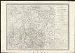
Vervolg der kaart van de grensscheiding tusschen het oud-Nederland en de Belgische provincien
1 : 100000 onder de directie en volgens het Topografisch sijstema van ... J.E. van Gorkum letter gegrav. door J.M. Huart ; situatie gegrav. door A. Bayly. [S.l.] : [s.n.]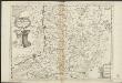
Ducea di Limburgo
1 : 200000 [Vincenzo Coronelli] [S.l.] : [s.n.]
Limburgensis ducatus nova descriptio
1 : 220000 Limbursko Martini, Aegidius Visscher, Nicolaus CI Visscher
X, uit: Carte chorographique des Pays-Bas Autrichiens / ... par le Comte de Ferraris ; gravée par L.A. Dupuis
1 : 86400 Annotatie: Lit.: Les militaires et la cartographie des Pays-Bas méridionaux et de la Principauté de Liège à la fin du XVIIe et au XVIII siècle / Claire Lemoine-Isabeau. - Bruxelles, 1984, p. 206-212; La cartographie au XVIIIe siècle et l'oeuvre du Comte de Ferraris (1726-1814) : colloque international, Spa, 8-11 sept. 1976. - Bruxelles, 1978; Met opdracht aan keizer Joseph II (bl.XVI); Met plattegrond van Brussel (bl. XXI), overzichtskaart (bl. XXII) en bladwijzer (bl. XXIII); Ontbreekt: bl. I-III en XXI; Voor aanwezige bladen zie overzichtsblad Ferraris, Johann Joseph; Dupuis, L. A. [S.l. : s.n.]
Le Limbourg ou sont Le Duché de Limbourg Le Comté de Dalem, Les Seigneuries de Fauquemont et de Rolduc
1 : 180000 Mollova mapová sbírka Sanson, Guillaume Jaillot, Alexis Hubert
Ducatus Limburg. [Karte], in: Gerardi Mercatoris et I. Hondii Newer Atlas, oder, Grosses Weltbuch, Bd. 1, S. 401.
1 Karte aus Atlas Mercator, Gerhard und Hondius, Jodocus Jansson, Jan
Ducatus Limburgum [Karte], in: Le théâtre du monde, ou, Nouvel atlas contenant les chartes et descriptions de tous les païs de la terre, Bd. 1, S. 363.
1 Karte aus Atlas Blaeu, Willem Janszoon und Blaeu, Joan Blaeu, Willem Janszoon
Ducatus Limburgum [Karte], in: Novus Atlas, das ist, Weltbeschreibung, Bd. 1, S. 336.
1 Karte aus Atlas Blaeu, Joan Blaeu, Willem Janszoon
Limburgensis ducatus tabula nova
1 : 180000 Aegidius Martini ... fecit et dedicavit anno 1603. [Antwerpen] : excusa sumptibus Joan. Baptistae Vrints, aemuli studii geographi
Ducatus Limburgum [Karte], in: Theatrum orbis terrarum, sive, Atlas novus, Bd. 1, S. 357.
1 Karte aus Atlas Blaeu, Joan Blaeu, Willem Janszoon
Ducatus Limburgum [Karte], in: Novus atlas absolutissimus, Bd. 3, S. 67.
1 Karte aus Atlas Janssonius Offizin
Le Limbourg ou sont le Duché de Limbourg, le Comté de Dalem, les Seigneuries de Fauquemont et de Rolduc : dressé sur les mémoires le pl[u]s recents
1 : 185000 par le Sr. Sanson. A Amsterdam : chez R. & J. Ottens
Le Limbourg, ou sont Le Duché De Limbourg Le Comté De Dalem; Les Seigneuries De Fauquemont Et De Rolduc [Karte], in: Atlas nouveau, contenant toutes les parties du monde [...], Bd. 2, S. 36.
1 Karte aus Atlas Sanson, Nicolas Jaillot, Alexis Hubert und Mortier, Pieter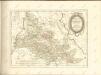

Carte Nouvelle de la Haute Partie de l'Archevesché et Eslectorat de Cologne Avec ses Enclaves dans les Pays Circomvoisins.
1 : 170000 Mollova mapová sbírka Sanson, Guillaume Ottens, Josua

Archiepiscopatus Coloniensis Pars Australis
1 : 260000 Mollova mapová sbírka Gigas, Johann Michael


