Maps of Rhein-Erft-Kreis
X ; 2.M., uit: Carte chorographique des Pays-Bas Autrichiens / ... par le Comte de Ferraris ; gravée par L.A. Dupuis
1 : 86400 Annotatie: Bladen linksboven genummerd met Romeinse cijfers, rechtsboven met een cijfer en een letter; Met opdracht aan keizer Joseph II (bl.XVI); Met plattegrond van Brussel (bl. XXI), overzichtskaart (bl. XXII) en bladwijzer (bl. XXIII); Annotatie geografische gegevens: Schaalstokken: Echelle de Toises ou de Lieues communes de France; Echelle de Verges ou de Lieues de Brabant; Echelle de Milles d'Allemagne (bl. XVII); Echelle de Mètres; In de hoeken lengte- en breedtematen T.M.e en T.P.e Joseph-Jean François Ferraris Comte de 1726-1814; L.A. Dupuis [S.l. : s.n.]
X, uit: Carte chorographique des Pays-Bas Autrichiens / ... par le Comte de Ferraris ; gravée par L.A. Dupuis
1 : 86400 Annotatie: Lit.: Les militaires et la cartographie des Pays-Bas méridionaux et de la Principauté de Liège à la fin du XVIIe et au XVIII siècle / Claire Lemoine-Isabeau. - Bruxelles, 1984, p. 206-212; La cartographie au XVIIIe siècle et l'oeuvre du Comte de Ferraris (1726-1814) : colloque international, Spa, 8-11 sept. 1976. - Bruxelles, 1978; Met opdracht aan keizer Joseph II (bl.XVI); Met plattegrond van Brussel (bl. XXI), overzichtskaart (bl. XXII) en bladwijzer (bl. XXIII); Ontbreekt: bl. I-III en XXI; Voor aanwezige bladen zie overzichtsblad Ferraris, Johann Joseph; Dupuis, L. A. [S.l. : s.n.]
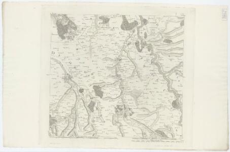
Bl. 36 Herzogenrath, 1904, uit: Atlas A.N.W.B.
1 : 200000 titelvariant: Atlas van Nederland van den A.N.W.B. Toeristenbond voor Nederland; Wielrijders-atlas van Nederland; Annotatie: Titel op bladwijzer: Atlas van Nederland van den A.N.W.B. Toeristenbond voor Nederland; Titel op legendablad: Wielrijders-atlas van Nederland; Voor aanwezige bladen zie overzichtsblad; Annotatie geografische gegevens: De serie bestaat uit 36 bladen ANWB ['s-Gravenhage : A.N.W.B.]
Descriptio agri civitatis Coloniensis : cum suis limitibus, terminis, viis, confiniis, interjacentibus, et adjacentibus pagis, villis, castris etc
1 : 60000 Cóvens et Mortier apud I. Cóvens et C. Mortier
Descriptio agri civitatis Coloniensis : cum suis limitibus, terminis, viis, confiniis, interjacentibus et adjacentibus pagis, villis, castris, etc. / [Joan Blaeu]
1 : 25000 Annotatie: Het eerst verschenen in: Atlas maior, sive Cosmographia Blaviana ... - Amstelaedami : sumptibus Ioannis Blaeu, 1662; Origineel is Blad 72 in atlas factice; Annotatie geografische gegevens: West boven Blaeu, Joan [Amsterdam : Joan Blaeu]
DESCRIPTIO AGRI | CIVITATIS COLONIENSIS, | Cum suis limitibus, terminis, viis, confiniis, interjacen- | tibus et adjacentibus Pagis, Villis, Castris, etc.
[Amsterdam : Joan Blaeu]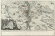
Franzosischer Uberfall der Vestung Rheinfels durch den Marquis de Chartres den 1. Dec. 1758 früh um 5. Uhr
Mollova mapová sbírka Fridrich, Jacob Andreas Fridrich, Jacob Andreas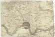
Descritione' del dis[tretto] della citta' di Colo[nia] con li suoi termi[ni] confini, villagi e terr[e &]
1 : 100000 Kolín nad Rýnem-oblast (Německo)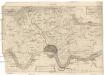
Descritione' del distretto della citta' di Colonia con li suoi termini confini, villagi e terre &
1 : 100000 Kolín nad Rýnem-oblast (Německo)
Plan von Coeln u. Umgegend
1 : 25000 Roos Lengfeld
Colonia Agrippina antiquissima, maxima ac celeberrima Libera Imperii Civitas et Emporium florentissimum
1 : 12000 Mollova mapová sbírka Seutter, Matthäus Seutter, Matthäus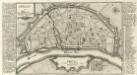
Cölln am Rhein.
1 : 18000 Mollova mapová sbírka Bodenehr, Gabriel Bodenehr, Gabriel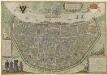
Colonia Agrippina
Mollova mapová sbírka Brachel, Peter von Hogenberg, Franz Braun, Georg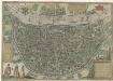
Colonia Agrippina
Mollova mapová sbírka Brachel, Peter von Hogenberg, Franz Braun, Georg
Colonia Agrippina
Mollova mapová sbírka Brachel, Peter von Hogenberg, Franz Braun, Georg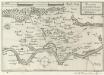
Accurata Territorii Coloniensis Descriptio
Mollova mapová sbírka Person, Nikolaus Person, Nicolas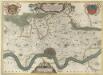
Descriptio Agri Civitatis Coloniensis
1 : 55000 Mollova mapová sbírka Blaeu, Joan Mortier, Pierre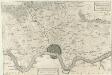
Descritione del distretto della Citta di Colonia con li suoi termini Confini, Villaggi, e Terre &
1 : 55000 Mollova mapová sbírka Hacque, Johann Baptist
Descriptio Agri Civitatis Coloniensis
1 : 55000 Mollova mapová sbírka Blaeu, Joan Blaeu, Joan I.
Cöln : [sheet] 2908
1 : 25000 Prussia (Germany). Landesaufnahme Konig[liche] Preuss[ische] Landes-Aufnahme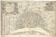
Nova et accurata ichnographia liberae ac imperialis civitatis Coloniensis anno 1752 confecta et ejusdem civitatis perillustribus strenuls consultis simisque dominis d[omi]nis consultibus et senatui
1 : 3800 Kolín nad Rýnem (Německo) Reinhardt, J. V. Rößler, Michael
Uebersichtsplan zur Banordnung für den Stadtkreis Cöln
1 : 15000 Gross, Wilh Wilh. Gross
Meßtischblatt 2971 : Brühl, 1936
1 : 250000 Brühl. - Hrsg. 1895, bericht. 1926, einz. Nachtr. 1933. - 1:25000. - [Berlin]: Reichsamt für Landesaufnahme, [19]36. - 1 Kt.
Meßtischblatt 2970 : Kerpen, 1895
1 : 250000 Kerpen. - Aufn. 1893. - 1:25000. - [Berlin]: Reichsamt für Landesaufnahme, 1895. - 1 Kt.
Meßtischblatt 2969 : Buir, 1895
1 : 250000 Buir. - Aufn. 1893. - 1:25000. - [Berlin]: Reichsamt für Landesaufnahme, 1895. - 1 Kt.
Meßtischblatt 5104 : Düren, 1940
1 : 250000 Düren. - Aufn. 1893, hrsg. 1895, bericht. 1938, Ausg. 1940, Nur für d. Dienstgebrauch!. - 1:25000. - [Berlin]: Reichsamt für Landesaufnahme, 1940. - 1 Kt.
Meßtischblatt 5103 : Eschweiler, 1942
1 : 250000 Eschweiler. - Aufn. 1893, hrsg. 1895, bericht. 1937, letzte Nachtr. 1940, Ausg. 1942, vorläuf. Ausg.. - 1:25000. - [Berlin]: Reichsamt für Landesaufnahme, 1942. - 1 Kt.
Meßtischblatt 2908 : Köln, 1926
1 : 250000 Köln. - Aufn. 1893, bericht. 1926. - 1:25000. - [Berlin]: Reichsamt für Landesaufnahme, 1926. - 1 Kt.
Meßtischblatt 2908 : Köln, 1895
1 : 250000 Köln. - Aufn. 1893. - 1:25000. - [Berlin]: Reichsamt für Landesaufnahme, 1895. - 1 Kt.