Maps of Isole Tremiti

INSVLÆ TREMITANÆ olim DIOMEDEÆ dictæ : [bird's-eye view]
[Amsterdam : Joan Blaeu]
Capitanata, olim Mesapiae et Iapygiae Pars. [Karte], in: Novus Atlas, das ist, Weltbeschreibung, Bd. 3, S. 294.
1 Karte aus Atlas Blaeu, Joan Blaeu, Willem Janszoon
Capitanata, olim Mesapiae et Iapygiae Pars. [Karte], in: Theatrum orbis terrarum, sive, Atlas novus, Bd. 3, S. 252.
1 Karte aus Atlas Blaeu, Joan Blaeu, Willem Janszoon
Contado di Molise et Principato Vltra
1 : 370000 Mollova mapová sbírka Schenk, Pieter Schenk, Peter I
Contado Di Molise et Principato Ultra [Karte], in: Novus Atlas, das ist, Weltbeschreibung, Bd. 3, S. 291.
1 Karte aus Atlas Blaeu, Joan Blaeu, Willem Janszoon
Abrvzzo et Terra di Lavoro
1 Karte : Kupferdruck ; 33 x 47 cm Mercator; Hondius Henricus Hondius
Abrvzzo et Terra di Lavoro
1 Karte : Kupferdruck ; 33 x 47 cm Mercator s.n.

Übersichtskarte von Mittel - Europa

XVIII, uit: General-Karte des oesterreichischen Kaiserstaates mit einem grossen Theile der angrenzenden Länder / durch Josef Scheda ... bearb. und hrsg
1 : 576000 Annotatie geografische gegevens: Maatstokken: oesterreichische Meilen, geografische oder deutsche Meilen, preussische Meilen, türkische Berri, französische Lieues, russische Werste; Maatstok per blad: wiener Klafter, öster. Meilen; Blad XIX: statistische en taalkundige informatie; Blad XIX: legenda [Wien : K.K. Militärisch-Geografisches Institut]
Übersichtskarte von Mittel - Europa

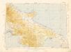
Rom, Ancona, Pescara, Velletri
1 : 750000 Ancona (Itálie) Lorenz, K. K. u. k. Militärgeographisches Institut
Rom, Ancona, Pescara, Velletri
1 : 750000 Ancona (Itálie) K. k. militär-geographisches Institut
XVII, uit: General-Karte des oesterreichischen Kaiserstaates mit einem grossen Theile der angrenzenden Länder / durch Josef Scheda ... bearb. und hrsg
1 : 576000 Annotatie geografische gegevens: Maatstokken: oesterreichische Meilen, geografische oder deutsche Meilen, preussische Meilen, türkische Berri, französische Lieues, russische Werste; Maatstok per blad: wiener Klafter, öster. Meilen; Blad XIX: statistische en taalkundige informatie; Blad XIX: legenda [Wien : K.K. Militärisch-Geografisches Institut]
Abruzzo Et Terra Di Lavoro. [Karte], in: Gerardi Mercatoris Atlas, sive, Cosmographicae meditationes de fabrica mundi et fabricati figura, S. 462.
1 Karte aus Atlas Mercator, Gerhard Montanus, Petrus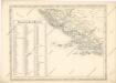
Strassen und Eisenbahnkarte des oesterreichischen Kaiserthumes

Strassen- und Eisenbahnkarte des oesterreichischen Kaiserthumes
1 : 864000 Blatt 14 Schaller, G. K.K. Militärisch-Geografisches Institut, Karten-Evidenthaltungs-Abteilung
Post und Eisenbahnkarte der Österreichisch-Ungarischen Monarchie
Letecká mapa Evropy


Blatt X, uit: Geologische Übersichts-Karte der Österreichisch-Ungarischen Monarchie / nach den Aufnahmen der K.K. Geologischen Reichsanstalt bearb. von Franz Ritter von Hauer ; gezeichn. von Eduard Jahn
1 : 576000 Annotatie geografische gegevens: Gebaseerd op veldwerk in de jaren 1850 tot 1865 Hauer, Franz Ritter von; Jahn, Eduard; Kaiserlich-Königliche Geologische Reichsanstalt, Wenen Wien : Beck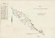
Carta indicante le tappe per le marchie militari
Dalmatien Marschroute, Militärkartografie Emilys
Strassen-Karte des Königreichs Dalmatien
1 : 430000 Chorvatsko
Karte des Königreiches Dalmatien

Coste de Dalmacie ou sont remarquees les places qui appartiennent a la Republique de Venise, a la Republique de Raguse, et au Grand Seignr des Turqs tirée de divers autheurs
1 : 880000 Dalmatien, Montenegro Sanson, Guillaume
Střední stará Italia
1 : 1720000 Itálie Fáborský, Jan B. nákladem Dědictví sv. Cyrilla a Methodia

Dalmatien, Montenegro.
1 : 1130000 Flemming, Carl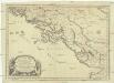
Coste de Dalmacie ou sont remarquees les places qui appartiennent a la republique di Venise, a la republique de Raguse et au grand seign. des Turqs
Dalmácie (Chorvatsko) Sanson, Nicolas Mariette, Pierre Pierre Mariette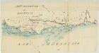
![INSVLÆ TREMITANÆ olim DIOMEDEÆ dictæ : [bird's-eye view]](https://images-2.georeferencer.com/images/iiif/260338752766/full/,300/0/native.jpg)

