Maps of Split-Dalmatia County

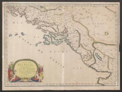
Coste de Dalmacie ou sont remarquees les places qui appartiennent a la Republique de Venise, a la Republique de Raguse, et au Grand Seignr des Turqs tirée de divers autheurs
1 : 880000 Dalmatien, Montenegro Sanson, Guillaume
Coste de Dalmacie ou sont remarquees les places qui appartiennent a la republique di Venise, a la republique de Raguse et au grand seign. des Turqs
Dalmácie (Chorvatsko) Sanson, Nicolas Mariette, Pierre Pierre Mariette
Special-Karte von Bosnien, der Herzegowina, dem Fürstenthum Montenegro und dem österreichischen Kronlande Dalmatien
1 : 600000 Bosna Handtke, Friedrich C. Flemming
Special-Karte von Bosnien, der Herzegowina, dem Fürstenthum Montenegro und dem österreichischen Kronlande Dalmatien
1 : 600000 Bosna Handtke, Friedrich C. Flemming
[Západní pobřeží Chorvatska]
1 : 864000 Chorvatsko Lanée

[Kaart], uit: Bosnien, Herzegowina, Dalmatien und Montenegro / bearb. von F. Handtke
1 : 600000 titelvariant: General-Karte von Bosnien, der Herzegowina, Montenegro und Dalmatien; Annotatie: Omslagtitel: General-Karte von Bosnien, der Herzegowina, Montenegro und Dalmatien Friedrich H. Handtke 1815-1879 Glogau : Carl Flemming
Carta Orografica della Dalmazia
Dalmatien, Montenegro, Relief
Das Oesterreichische-Kaiserthum
[Montenegro und angrenzende Länder]
Bělehrad (Srbsko : oblast)
Dalmatien, Bosnien und Hercegovina

Bosnien, Herzegowina, Dalmatien und Montenegro
1 : 600000 Bosna Handtke, Friedrich Carl Flemming
Bosnien, Herzegowina, Dalmatien und Montenegro
1 : 600000 Bosna Handtke, Friedrich Carl Flemming
Übersichtskarte des vecchio, nuovo e nuovissimo Acquisto
Dalmatien Jabornigg von Altenfels, Rudolf
Herzegovina, Montenégro, Albanie Superieure
Nouvel atlas physique politique et historique de l'Empire ottoman et des états limitrophes en Europe, en Asie et en Afrique, en quarante feuilles Hellert, J.J. Bellizard, Dufour et Cie
Carta Idrografika della Dalmazia
Dalmatien Hydrologie

Strategische-Überischts-Karte von Bosnien, Hercegovina und Montenegro
1 : 600000 Bosna a Hercegovina K.k. Generalstab
Urbinas Handschrift
Albanien Trattato della pittura / Handschrift / Rom / Vatikanische Bibliothek / Cod. Urb. Lat.
Kreiseinteilung von Dalmatien
Dalmatien Verwaltungsgliederung Jabornigg von Altenfels, Rudolf
Dalmatien, Montenegro.
1 : 1130000 Flemming, Carl
Katastralkarte
Dalmatien Katasterplan Jabornigg von Altenfels, Rudolf
Herzegowina 1865
Herzegowina Grenze Zwick, J.
G.8. Cattaro, uit: [Übersichtskarte von Europa 1:750.000]
1 : 750000 Wien : K.u.K. Militärgeographisches Institut
Uebersicht der Distanzen und Peripherien von Dalmazien und den hierzu gehörigen Inseln
1 : 646768 Dalmatien Vetter von Lilienberg, Wenzel Alois Jabornigg von Altenfels, Rudolf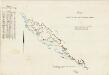
Carta indicante le tappe per le marchie militari
Dalmatien Marschroute, Militärkartografie Emilys
Strassen-Karte des Königreichs Dalmatien
1 : 430000 Chorvatsko
Karte des Königreiches Dalmatien

Totius Graeciae descriptio
Griechenland Albanien