Maps of Ieper

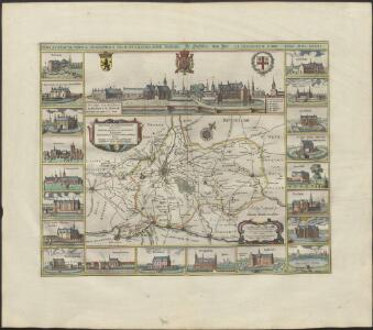
NOVA ET EXACTA TABVLA GEOGRAPHICA SALÆ ET CASTELLANIÆ IPRENSIS. De Casselrie van Ipre. LA CHASTELENIE D'IPRE. ANNO M DC XXXXI
Vedastus du Plouich fec. Henricus Hondius excudebat
Carte Particuliere des environs de Menin, Courtray, Ypre, Dixmude et Deynse
1 : 250000 Mollova mapová sbírka Seutter, Matthäus Seutter, Matthäus
Carte Particuliere des environs de Menin, Courtray, Ypre, Dixmude et Deynse
1 : 116600 Mollova mapová sbírka Fricx, Eugène Henry Harrewyn, Jacques Fricx, Eugené Henry
Menin in Flandern mitt nahe gelegenen Staedtten Ypern, Cortryck, Ryssel, Dornick etc.
1 : 250000 Mollova mapová sbírka Bodenehr, Gabriel Bodenehr, Gabriel
Carte particuliere des environs de Menin, Courtray, Ypre, Dixmunde, et Deynse
1 : 110000 Belgie Fricx, Eugene Henry chez Eugene Henry Friex
Map showing progress in Ypres area. Oct. 1917.
1 : 40000 First World War map showing progress in Ypres area. 12th October 1917. War Office
Front at Ypres. Oct. 1917. Special.
1 : 40000 First World War map of the Front at Ypres. Oct. 1917. Special. Charts British progress on the front with dates. War Office
Menin in Flandern mitt nahegelegenen Staedten Ypern, Cortryck, Ryssel, Dornick etc
1 : 252000 Flandry Bodenehr, Gabriel G. Bodenehr
Map of water supply: Ostend
1 : 100000 Series of maps on water supplies. Ostend. War Office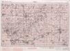
Ypres. Sheeet 28. no.4
1 : 40000 First World War map of Ypres. Sheeet 28. 1915. [GSGS 2743] Has height shading and contours. War Office
Ypres. Sheeet 28. no.1
1 : 40000 First World War map of Ypres. Sheeet 28. 1915. [GSGS 2743] Has height shading and contours. War Office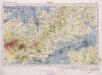
Ypres. Sheeet 28. no.2
1 : 40000 First World War map of Ypres. Sheeet 28. 1915. [GSGS 2743] Has height shading and contours. War Office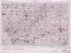
Ypres. Sheeet 28. no.3
1 : 40000 First World War map of Ypres. Sheeet 28. 1915. [GSGS 2743] Has height shading and contours. War Office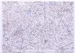
France & Belgium Scale 1 : 25,000, Tourcoing
Sheet 52NW from the map series: France & Belgium. Scale 1 : 25,000. [G.S.G.S. No. 4041. A.M.S. M863] [London] : War Office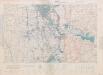
Belgium: trench maps
1 : 20000 First World War map of Beligium. Trenches corrected to 25.1.17 and 7.5.17. Sheet 20.N.W. War Office
Disegno di Covtray
Kortrijk (Belgie) Bouttats, Gerhaert
Plan parcellaire de la commune de Poperinghe : avec les mutations
1 : 5000 Royal Library of Belgium Map Room Popp, Philippe Christian (1805-1879) Popp, Philippe Christian (1805-1879)
Plan parcellaire de la commune de Poperinghe : avec les mutations
1 : 5000 Royal Library of Belgium Map Room Popp, Philippe Christian (1805-1879) Popp, Philippe Christian (1805-1879)
Plan parcellaire de la commune de Langemarcq : avec les mutations
1 : 5000 Royal Library of Belgium Map Room Popp, Philippe Christian (1805-1879) Popp, Philippe Christian (1805-1879)
Plan parcellaire de la commune de Langemarcq : avec les mutations
1 : 5000 Royal Library of Belgium Map Room Popp, Philippe Christian (1805-1879) Popp, Philippe Christian (1805-1879)
Hostile Artillery Dispositions. Oostnieuwkerke
1 : 20000 First World War map. Hostile Artillery Dispositions. Oct.3rd. 1917. Sheet Oostnieuwerke. War Office
Plan parcellaire de la commune de Roulers : avec les mutations
1 : 5000 Royal Library of Belgium Map Room Popp, Philippe Christian (1805-1879) Popp, Philippe Christian (1805-1879)
Plan parcellaire de la commune de Reninghelst : avec les mutations
1 : 5000 Royal Library of Belgium Map Room Popp, Philippe Christian (1805-1879) Popp, Philippe Christian (1805-1879)
Plan parcellaire de la commune de Reninghelst : avec les mutations
1 : 5000 Royal Library of Belgium Map Room Popp, Philippe Christian (1805-1879) Popp, Philippe Christian (1805-1879)
Plan parcellaire de la commune de Moorslede : avec les mutations
1 : 5000 Royal Library of Belgium Map Room Popp, Philippe Christian (1805-1879) Popp, Philippe Christian (1805-1879)
Plan parcellaire de la commune de Merckem : avec les mutations
1 : 7500 Royal Library of Belgium Map Room Popp, Philippe Christian (1805-1879) Popp, Philippe Christian (1805-1879)
Plan parcellaire de la commune de Lichtervelde : avec les mutations
1 : 5000 Royal Library of Belgium Map Room Popp, Philippe Christian (1805-1879) Popp, Philippe Christian (1805-1879)
Plan parcellaire de la commune de Ploegsteert : avec les mutations
1 : 5000 Royal Library of Belgium Map Room Popp, Philippe Christian (1805-1879) Popp, Philippe Christian (1805-1879)
Plan parcellaire de la commune de Rumbeke : avec les mutations
1 : 5000 Royal Library of Belgium Map Room Popp, Philippe Christian (1805-1879) Popp, Philippe Christian (1805-1879)