Maps of Mesen

Plan parcellaire de la commune de Ploegsteert : avec les mutations
1 : 5000 Royal Library of Belgium Map Room Popp, Philippe Christian (1805-1879) Popp, Philippe Christian (1805-1879)
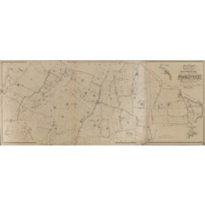
Plan parcellaire de la commune de Warneton : avec les mutations
1 : 2500 Royal Library of Belgium Map Room Popp, Philippe Christian (1805-1879) Popp, Philippe Christian (1805-1879)
Plan parcellaire de la commune de Messines : avec les mutations
1 : 5000 Royal Library of Belgium Map Room Popp, Philippe Christian (1805-1879) Popp, Philippe Christian (1805-1879)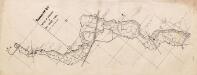
Detail of Wire, etc., in No Man’s Land [south of Ypres]
1 : 5000 Plan No. 83A. (84A.) Detail of Wire, etc., in No Man’s Land [south of Ypres]. Sheet 28. War Office
ARMENTIERES
Vedastus de Plouich Fecit [Amsterdam : Joan Blaeu]
Plan parcellaire de la commune de Neuve-Eglise : avec les mutations
1 : 5000 Royal Library of Belgium Map Room Popp, Philippe Christian (1805-1879) Popp, Philippe Christian (1805-1879)
Plan parcellaire de la commune de Wulverghem : avec les mutations
1 : 5000 Royal Library of Belgium Map Room Popp, Philippe Christian (1805-1879) Popp, Philippe Christian (1805-1879)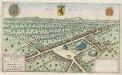
NIEV [–] KERCKE : [bird's-eye view]
[Amsterdam : Joan Blaeu]
Ditiuncula in Confiniis | Flandriæ Gallicanæ | sita, vulgo | LE PAYS DE | LALLEVE | Sub Dominio Abbatis | S. Vedasti ad Atrebatum
Vedastus du Plouich auctore ; V. du Plouich fecit [Amsterdam : Joan Blaeu]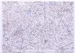
France & Belgium Scale 1 : 25,000, Tourcoing
Sheet 52NW from the map series: France & Belgium. Scale 1 : 25,000. [G.S.G.S. No. 4041. A.M.S. M863] [London] : War Office
Plan parcellaire de la commune de Wytschaete : avec les mutations
1 : 5000 Royal Library of Belgium Map Room Popp, Philippe Christian (1805-1879) Popp, Philippe Christian (1805-1879)
Map of water supply: Lille
1 : 100000 Series of maps on water supplies. Lille War Office
Map of water supply: Ostend
1 : 100000 Series of maps on water supplies. Ostend. War Office
XI [Annonce de l'ouvrage], uit: Carte chorographique des Pays-Bas Autrichiens / ... par le Comte de Ferraris ; gravée par L.A. Dupuis
1 : 86400 Annotatie: Lit.: Les militaires et la cartographie des Pays-Bas méridionaux et de la Principauté de Liège à la fin du XVIIe et au XVIII siècle / Claire Lemoine-Isabeau. - Bruxelles, 1984, p. 206-212; La cartographie au XVIIIe siècle et l'oeuvre du Comte de Ferraris (1726-1814) : colloque international, Spa, 8-11 sept. 1976. - Bruxelles, 1978; Met opdracht aan keizer Joseph II (bl.XVI); Met plattegrond van Brussel (bl. XXI), overzichtskaart (bl. XXII) en bladwijzer (bl. XXIII); Ontbreekt: bl. I-III en XXI; Voor aanwezige bladen zie overzichtsblad Ferraris, Johann Joseph; Dupuis, L. A. [S.l. : s.n.]
Menin in Flandern mitt nahegelegenen Staedten Ypern, Cortryck, Ryssel, Dornick etc
1 : 252000 Flandry Bodenehr, Gabriel G. Bodenehr
NOVA ET EXACTA TABVLA GEOGRAPHICA SALÆ ET CASTELLANIÆ IPRENSIS. De Casselrie van Ipre. LA CHASTELENIE D'IPRE. ANNO M DC XXXXI
Vedastus du Plouich fec. Henricus Hondius excudebat
Carte Particuliere des environs de Menin, Courtray, Ypre, Dixmude et Deynse
1 : 250000 Mollova mapová sbírka Seutter, Matthäus Seutter, Matthäus
Menin in Flandern mitt nahe gelegenen Staedtten Ypern, Cortryck, Ryssel, Dornick etc.
1 : 250000 Mollova mapová sbírka Bodenehr, Gabriel Bodenehr, Gabriel
DITIO CASLETANA IN COMITATU FLANDRIÆ Vulgó Cassel Ambacht
Vedastus du Plouich invenit et fecit Amstelodami | Sumtibus Henrici Hondy
Galloflandria
1 : 170000 Douai (Francie) Doué, Martin Blaeu, Willem Janszoon Guiljelmus Blaeu
Flandriae Comitatus pars occidentalis
1 : 133000 Mollova mapová sbírka Visscher, Nicolaes Schenk, Peter II
GALLOFLANDRIA, | in qua CASTELLANIÆ | LILANA, DVACENA, & ORCHIESIA, cum dependentibus; | necnon TORNACVM, & TORNACESIVM
Auctore Martino Doué Gallo-Flandro. Guiljelmus Blaeu excudit.
Flandriae comitatus pars media, comprehendens castellaniam Yprensem, Cortracensem, Aldenardensem
1 : 130000 per Nicol. Visscher Amst. Bat. Amst. Bat. : per Nicol. Visscher
Map of water supply: Hazebrouck
1 : 100000 Series of maps on water supplies. 2nd Army area water supply. Secret. Hazebrouck War Office
Flandriae Comitatus Pars Australis
1 : 133000 Mollova mapová sbírka Visscher, Nicolaes Schenk, Peter II
Flandriae comitatus pars Australis, in Castellaniam insulanam, Balliviatum duacensem, territorium Tornacensem, et in suasquasque ditiones subjacentes
1 : 140000 accuratissima divisa per Nicolaum Visscher Amst. Bat. Amst. Bat. : per Nicolaum Visscher
Le Diocese De Tournay ou font Exactement Marquées Les Lignes Levé & Gravé Par Ordre Expres Du Roy [...] [Karte], in: Atlas nouveau, contenant toutes les parties du monde [...], Bd. 2, S. 52.
1 Karte aus Atlas Sanson, Nicolas Jaillot, Alexis Hubert und Mortier, Pieter
Gallo Flandria, in qua Castellaniae Lilana, Duacena, & Archiesia, cum dependentibus; neenon Tornacum,& Tornacesium. [Karte], in: Novus Atlas, das ist, Weltbeschreibung, Bd. 1, S. 368.
1 Karte aus Atlas Blaeu, Joan Blaeu, Willem Janszoon
La Flandre gallicane conquise par le roy
1 Karte : Kupferdruck ; 42 x 38 cm Duval chez l'auteur proche le palais sur le quay de l'Orloge proche la ruë de Harlay