Maps of East Flanders

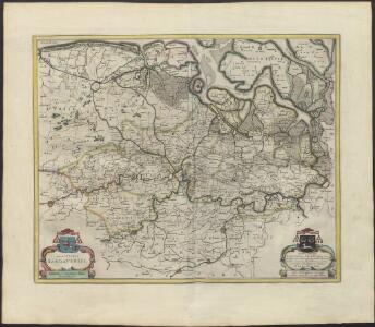
EPISCOPATVS | GANDAVENSIS
Iohannes et Cornelius Blaeu | Excudebant
Fiandra, parte occidentale
1 : 220000 [Vincenzo Coronelli] [S.l.] : [s.n.]
Flandriae Partes duae, quarum altera Proprietaria, altera Imperialis vulgo dicitur. [Karte], in: Le théâtre du monde, ou, Nouvel atlas contenant les chartes et descriptions de tous les païs de la terre, Bd. 1, S. 400.
1 Karte aus Atlas Blaeu, Willem Janszoon und Blaeu, Joan Blaeu, Willem Janszoon
Flandriae Partes duae, quarum altera Proprietaria, altera Imperialis vulgo dicitur. [Karte], in: Novus atlas absolutissimus, Bd. 3, S. 132.
1 Karte aus Atlas Janssonius Offizin
Flandriae Partes duae, quarum altera Proprietaria, altera Imperialis vulgo dicitur. [Karte], in: Theatrum orbis terrarum, sive, Atlas novus, Bd. 1, S. 386.
1 Karte aus Atlas Blaeu, Joan Blaeu, Willem Janszoon
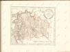
Carte topographique tres exacte des Pais-Bas
1 : 230000 Aalst (Belgie) W. D. S. Jaeger, Johann Christian I.C. Iaeger
Flandriae Partes duae, quarum altera Proprietaria, altera Imperialis vulgo dicitur. [Karte], in: Novus Atlas, das ist, Weltbeschreibung, Bd. 1, S. 371.
1 Karte aus Atlas Blaeu, Joan Blaeu, Willem Janszoon
[106][109] Flandriae partes duae ..., uit: Atlas sive Descriptio terrarum orbis
Annotatie: Gedigitaliseerde versie. Amsterdam. Heiloo : Picturae (vervaardiger), 2015. tiff-bestand. Gedigitaliseerd: 07-01-2015; Origineel: Universiteitsbibliotheek Vrije Universiteit (XL.05127.-) ; Netherlands; Titelpagina ontbreekt Wit, Frederik de Amsterdam : Frederick de Wit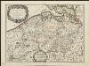
Flandre Espagnole, et Flandre Hollandoise
1 : 250000 dressée sur les Memoires les plus nouveaux par le Sr. Sanson A Paris : chez H. Jaillot, joignant les grands Augustins aux 2 globes
FLANDRIÆ | Partes duæ, | quarum altera | PROPRIETARIA, | altera | IMPERIALIS | vulgo dicitur.
[Amsterdam : Joan Blaeu]

Episcopatvs Gandavensis
1 : 190000 Mollova mapová sbírka Blaeu, Joan Blaeu, Cornelis
Flandre Espagnole et Flandre Hollandoise
1 : 266000 Mollova mapová sbírka Sanson, Nicolas Jaillot, Alexis Hubert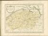

Carte Contenant le Pais entre Nieuport l'Ecluse Anvers Ypres et Bruxelles
1 : 200000 Mollova mapová sbírka Le Rouge, Georges-Louis Le Rouge, Georges-Louis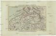
Ausfluss der Schelde in die Nord-See
1 : 500000 Nizozemsko Adam, Jakob Artaria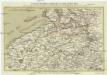
Ausfluss der Schelde in die Nord-See
1 : 500000 Nizozemsko Adam, Jakob Artaria Comp.
Paasche's Verkehrskarte von Belgien. Blatt 1, Gent-Brussel
1 : 200000 Paasche, Walter, cartographe 18..-1932 Stuttgart : Paasche & Lutz
Flandria et Zeelandia Comitatvs
1 : 266000 Mollova mapová sbírka Blaeu, Willem Janszoon Blaeu, Willem Jansz.
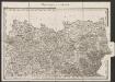
Die Graffschaft Flandern nach dero Eintheilunge
1 : 1330000 Mollova mapová sbírka Bodenehr, Gabriel Bodenehr, Gabriel
Zeeland
1 : 790000 P.H. Witkamp del. D. Veelwaard sculps. Amsterdam : C.L. Brinkman exc.
Le Comte de Flandre ou se trouvent les Environs de Donquerque, Nieuport, Ostende, Bruges, Gand, Ouden, Arde, Tournay, Lille, Yppes, et Courtray
1 : 650000 Mollova mapová sbírka Fer, Nicolas de Inselin, Charles Fer, Nicolas de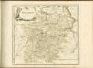
Habes hic Novam & accuratißimam descriptionem tractus illius Flandriae [...] [Belgien, Flandern] [Karte], in: Gerardi Mercatoris Atlas, sive, Cosmographicae meditationes de fabrica mundi et fabricati figura, S. 293.
1 Karte aus Atlas Mercator, Gerhard Montanus, Petrus
Flandriae comitatus pars Batava tam in ejusdem subjacentia quam vicina territoria
1 : 150000 accuratissima divisa per Nicolaum Visscher Amst. Bat. [Amsterdam] : nunc apud Petrum Schenk Iunior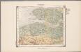
21. Walcheren, uit: Geologische kaart van Nederland / door W.C.H. Staring ; bew. aan de Topographische Inrichting
1 : 200000 Winand Carel Hugo Staring 1808-1877; Topographische Inrichting, 's-Gravenhage 's-Gravenhage : Belinfante
Brüssel 82, uit: [W. Liebenow's Special-Karte von Mittel-Europa]
1 : 300000 titelvariant: W. Liebenow's Mittel-Europa; Annotatie: Titel boven de bladen: W. Liebenow's Mittel-Europa Johannes Wilhelm Liebenow 1822-1897 Hannover : Hermann Oppermann
Brüssel 82, uit: Special-Karte von Mittel-Europa / nach amtlichen Quellen bearbeitet von W. Liebenow
1 : 300000 titelvariant: W. Liebenow's Mittel-Europa; Annotatie: Titel boven de bladen: W. Liebenow's Mittel-Europa Johannes Wilhelm Liebenow 1822-1897 Frankfurt a. M. : Ludwig Ravenstein