Maps of Flemish Region
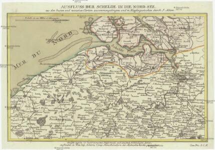
Ausfluss der Schelde in die Nord-See
1 : 500000 Nizozemsko Adam, Jakob Artaria
Ausfluss der Schelde in die Nord-See
1 : 500000 Nizozemsko Adam, Jakob Artaria Comp.
Comitatus Zeelandiae novissima descriptio
1 : 220000 auct. Petrum Verbist. Antverpiae : apud Petrum Verbist sub signo Americae in platea quae vulgo Lombardorum moenia dictur
Nouvelle carte de la province de Zélande
1 : 115000 dressée et gravée par C. van Baarsel et fils. A La Haye : chez F.J. Weygand, marchand de cartes-geographiques de S.M. le Roi des Pays-Bas
Neuer Plan von den Lauf der Schiffbaren Schelde von Antwerpen durch Holländisch Seeland, bis zu deren Mündung an der Nord-See
1 : 550000 I. Berlia sc. Prag : aus der von Schönfeldischen Officin
Zelandiae typus.
1 : 420000 [Amsterdam] : [Willem Jansz. Blaeu]
Abris der Schelde, soweit sie schiffbar ist, von Antwerpen bis an die Nord-See
1 : 550000 Math. Pock geometra sc. Salisburgi. Salzburg : Lor. Hübner
Flandria et Zeelandia comitatvs
1 : 350000 Flandry Blaeu, Willem Janszoon apud Guiljelmum Blaeuw
Zeeland
1 : 790000 P.H. Witkamp del. D. Veelwaard sculps. Amsterdam : C.L. Brinkman exc.
Fiandra, parte occidentale
1 : 220000 [Vincenzo Coronelli] [S.l.] : [s.n.]
A new map of Zealand : with the rivers Schelde, part of Holland, Flanders & Brabant, shewing the situation of the Schelde.
1 : 245000 London : Jno. Stockdale Picadilly
A new map of Zealand : with the rivers Schelde, part of Holland, Flanders & Brabant, shewing the situation of the present dispute between the Emperor and the Dutch.
1 : 245000 London : Jno. Stockdale Picadilly
[Belgie a Nizozemí]
Belgie Schraembl, Franz Anton F.A. Schraembl
Kaart der overstroomingen in het Koningrijk der Nederlanden op de 3, 4, 5 en 6 Februarij 1825 : zuidelijk gedeelte.
1 : 450000 ['s-Gravenhage] : [J. Immerzeel jr.]
Carte des bouches de l'Escaut
1 : 500000 dressée par Th. Duvotenay gravée par Ch. Dyonnet. Paris : Lheureux et Cie
(No. I), uit: [Generale kaart van het Koningrijk Holland] / [onder leiding van C.R.T. Krayenhoff]
1 : 115200 Annotatie: Beschreven in: Topographische en militaire kaart van het Koningrijke der Nederlanden / J.A. van der Linden. - Bussum : Fibula-van Dishoeck, cop. 1973 (p. 12-13), en: Choro-topographische kaart der Noordelijke provinciën van het Koningrijk der Nederlanden / P.W. Geudeke. - Haarlem : Fibula-Van Dishoeck, [1979]; Voor aanwezige bladen zie overzichtsblad Krayenhoff, C. R. T. [Amsterdam : Dépôt Generaal van Oorlog]
Neuer Plan von den Lauf der Schiffbaren Schelde, von Antwerpen durch Holländisch Seeland, bis zu deren Mündung an der Nord See
1 : 560000 Nizozemsko Berka, Jan aus der von Schönfeldischen Officin
Neuer Plan von den Lauf der Schiffbaren Schelde, von Antwerpen durch Holländisch Seeland, bis zu deren Mündung an der Nord See
1 : 560000 Nizozemsko Berka, Jan aus der von Schönfeldischen Officin
Neuer Plan von den Lauf der Schiffbaren Schelde, von Antwerpen durch Holländisch Seeland, bis zu deren Mündung an der Nord See
1 : 560000 Nizozemsko Berka, Jan Schönfeldischen Officin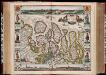
Comitatus Zelandiae nova descriptio anno 1657 / [Nicolaes Visscher]
1 : 200000 Annotatie: Origineel is Blad 47 in atlas factice; Met panorama's van Middelburg, Vlissingen en Zierikzee; Met kostuurfiguren naast de kaart; Annotatie geografische gegevens: West boven Visscher, Nicolaes (1618-1679) [Amsterdam : N. Visscher excudebat]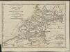
Esquisse géographique du cours de l'Escaut d'Anvers à la mer, de ses bouches, et de ses communications avec l'intérieur de la Flandre, de la Zelande et de la Hollande : Les Isles de Walcheren, Wolfertsdyk etc]
1 : 510000 par L.S. de La Rochette gravé par J. Turpin à La Haye. [London] : [Faden]
North West Europe: front line, June 27th, 1916, from Nieuport to Lens
1 : 250000 First World War map of North West Europe. Front line, June 27th, 1916, from Nieuport to Lens. War Office

Zeelandia Comitatus. [Karte], in: Novus Atlas, das ist, Weltbeschreibung, Bd. 1, S. 405.
1 Karte aus Atlas Blaeu, Joan Blaeu, Willem Janszoon
Zeelandia Comitatus. [Karte], in: Le théâtre du monde, ou, Nouvel atlas contenant les chartes et descriptions de tous les païs de la terre, Bd. 1, S. 436.
1 Karte aus Atlas Blaeu, Willem Janszoon und Blaeu, Joan Blaeu, Willem Janszoon
Zeelandia Comitatus. [Karte], in: Theatrum orbis terrarum, sive, Atlas novus, Bd. 1, S. 437.
1 Karte aus Atlas Blaeu, Joan Blaeu, Willem Janszoon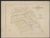
Zeelandia Comitatus. [Karte], in: Gerardi Mercatoris et I. Hondii Newer Atlas, oder, Grosses Weltbuch, Bd. 1, S. 459.
1 Karte aus Atlas Mercator, Gerhard und Hondius, Jodocus Jansson, Jan
EPISCOPATVS | GANDAVENSIS
Iohannes et Cornelius Blaeu | Excudebant
Zeelandia Comitatus
1 : 700000 Petrus Kaerius Flander caelavit aetatis 75. [Amsterdam] : [Johannes Janssonius]