Maps of Burkina Faso
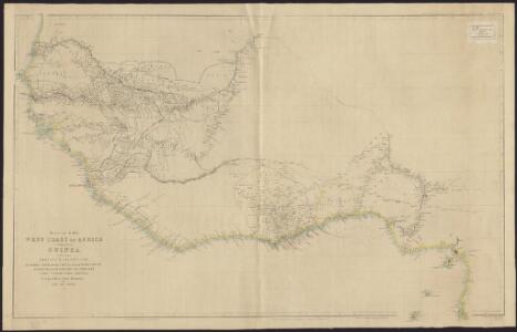
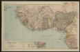
Map of the West Coast of Africa comprising Guinea, and the British possessions at Sierra Leone, on the Gambia and the Gold Coast, together with the countries within the courses of the rivers Senegal, Gambia & Kowara
1 : 3200000 comp. from official documents, by John Arrowsmith London : Arrowsmith
Mittel-West-Afrika
Atlas der evangelischen Missions-Gesellschaft zu Basel Locher; Gross, Rudolf Im Verlag des Comptoires der evangelischen Missions-Gesellschaft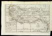
A New Map Of That Part Of Africa Called The Coast Of Guinea
This map has been taken from William Snelgrave's 'A New Account of some parts of Guinea' and shows the area in which Snelgrave - a British sea captain ? traded in slaves. His area of operations is stated as being about 700 leagues (around 2000 miles) from Sherbarow River (Sherbro channel, Sierra Leone) to Cape Lopez Gonsalves (Cape Lopez, Gabon).
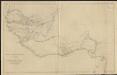
Sketch of the West Coast of Africa from the Senegal to Fernando Po
1 : 12930000 John Arrowsmith London : John Murray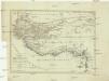
Charte von Senegambien und Ober-Guinea nebst dem innern Nigritien
1 : 8500000 Afrika severozápadní
CHARTE von SENEGAMBIEN UND OBER-GUINEA nebst dem innern Nigritien
1 : 8540000 Gambie
Charte von Senegambien und Ober-Guinea nebst dem innern Nigritien
1 : 8540000 Gambie
Western Africa.
1 : 10500000 Tallis, J. & F.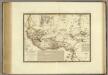
Senegambie, Soudan, Guinee Septentrionale.
1 : 8250000 Brue, Adrien Hubert, 1786-1832
Spezial - karte von AfricaSektion West-Sudân (4)
1 : 4000000 1 full d'1 mapa en 10 fulls i estoig Hermann Habenicht; Justus Perthes
Justus Perthes' Africa (10 sheets), section Western Sudan
Afrique centrale. Sénégal-Niger
1 : 8000000 Niox, Gustave-Léon 1840-1921 Paris : Ch. Delagrave
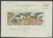
Gvinea propria nec non Nigritiæ vel terræ Nigrorvm maxima pars
1 Karte : Kupferdruck ; 44 x 54 cm Anville; Haas; Desmarchais Homännische Erben
Gvinea propria nec non Nigritiæ vel terræ Nigrorvm maxima pars
1 Karte : Kupferdruck ; 44 x 54 cm Anville; Haas; Desmarchais Homännische Erben
Westliches Mittel-Africa, Senegambien, Sudan, Ober-Guinea und einen Theil der Sahara umfassend oder die Stufenländer des mittlern Africa's und Nordrand von Hochafrica
1 : 6000000 entworfen und gezeichnet von C.F. Weiland gestochen von K.J. Mädel sen. Weimar : Geographisches Institut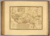
Senegambie, Soudan, Guinee Septentrionale.
1 : 8250000 Picquet, C.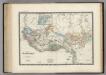
Senegambie, Soudan, Guinee.
1 : 8600000 Levasseur, E.
Spezial-Karte von Afrika
1 : 4000000 Blatt 4 Habenicht, Hermann Perthes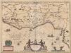
Guinea [Karte], in: Novus Atlas, das ist, Weltbeschreibung, Bd. 2, S. 249.
1 Karte aus Atlas Blaeu, Joan Blaeu, Willem Janszoon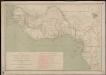
Carte des missions catholiques du Soudan français et de la côte occidentale d'Afrique
1 : 4000000 Vuillot, Paul 18..-19.. [Lyon : Oeuvre de la propagation de la foi]
Guineae Nova Descriptio [Karte] I. S. Thomae. [Nebenkarte], in: Gerardi Mercatoris Atlas, sive, Cosmographicae meditationes de fabrica mundi et fabricati figura, S. 508.
1 Karte aus Atlas Mercator, Gerhard Montanus, Petrus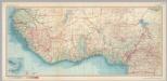
West Africa. Pergamon World Atlas.
1 : 5000000 Polish Army Topography Service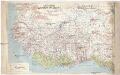
Afrique occid.le franç.se
1 : 3000000 Afrika západní Meunier, Alexandre
Carte des fuseaux horaires de l'Afrique occidentale française
1 : 6000000
Carte des fuseaux horaires de l'Afrique occidentale française
1 : 6000000 Afrika západní Service géographique des colonies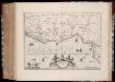
Gvinea
1 : 6550000 Annotatie: Kaart uitg. in de periode ca. 1647-ca. 1657; Origineel is Blad 208 in atlas factice; Annotatie geografische gegevens: Schaalstokken op kaart: 30 Milliaria Germanica communia (=3,5 cm), en: 35 Leucæ Hispanicæ (=3,5 cm) Amstelodami : Sumptibus Joannis Janßonii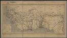
Afrique Occidentale Française
1 : 9000000 Barralier, Emmanuel 18..-19.. Service Géographique des Colonies
Gvinea propria nec non Nigritiae vel Terrae Nigrorvm maxima pars, geographis hodiernis dicta ultraq AEthiopia inferior, & hujus quidem pars australis itineri Guineensi D. de Marchais
Afrika západní Anville, Jean-Baptiste Bourguinon d' Hase, Johann Matthias Homannianos Heredes
GVINEA propria nec non NIGRITIAE vel Terrae NIGRORVM maxima pars, geographis hodiernis dicta utraq[ue] AETHIOPIA INFERIOR, & hujus quidem pars australis
1 : 7400000 Afrika západní Anville, Jean-Baptiste Bourguinon d' studio & labore Homannianorum Heredum