Maps of Noord-Brabant
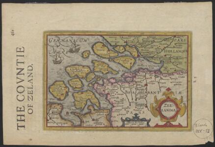
Zeelandia
1 : 780000 [engraver: Jodocus Hondius I] [S.l.] : [s.n.]
Zeelandiae Comitatus
1 : 600000 Petrus Kaerius caelavit. [Amsterdam] : [Jan Evertsz. Cloppenburch]

Zeelandiae Comitatus
1 : 600000 [engraver: Petrus Kaerius] [Amsterdam] : [Johannes Janssonius van Waesberge]
[14], uit: Hydro-Oro und Chorographische General Karte des Koenigreichs der Niederlande und der angrenzenden Länder bis Paris : mit der Angabe der Kunst und Heer-Strassen und der Entfernung der Poststationen / ... zusammengetragen und reducirt von ... Wilhelm Müller
1 : 400000 titelvariant: Generalkarte des Koenigreichs Hannover; Annotatie: 1e supplement bij: Generalkarte des Koenigreichs Hannover (1818) Müller, Wilhelm (fl. 1818) [Hannover : Wilhelm Müller]
Zelandia Comitatus [Karte], in: Gerardi Mercatoris Atlas, sive, Cosmographicae meditationes de fabrica mundi et fabricati figura, S. 302.
1 Karte aus Atlas Mercator, Gerhard Montanus, Petrus
Zelandicarum insularum exactissima et nova descriptio
1 : 540000 auctore D. Jacobo à Daventria Johan Bussemecher excudit ; Henricus Nagell fecit. [Coln am Rhein] : [Buxemacher]
Bijlage 11, uit: Eindverslag over de onderzoekingen en uitkomsten van den Dienst der Rijksopsporing van Delfstoffen in Nederland, 1903-1916
Annotatie: Met lit. opg Departement van Landbouw, Nijverheid en Handel. Dienst der Rijksopsporing van Delfstoffen ['s-Gravenhage : Martinus Nijhoff]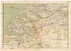
Zeeland en Noord-Brabant
1 : 300000 Brabantsko Seyffardt's boekhandel
De Zuider Deelen Der Provincien van Holland en Untrecht; Het Graafschap Zeeland, Hollands Brabant, Het Gebied van Antwerpen en Staats Vlaanderen. Ofte Het Noorder Deel van De Stoel des Oorlogs In Nederland tot Parys toe
1 : 250000 Mollova mapová sbírka Allard, Abraham Allart, Abraham
Zelandicarum insularum exactissima et nova descriptio
1 : 250000 auctore D. Jacobo a Daventria [Frans Hogenberg sculpsit] [S.l.] : [s.n.]
Zelandicarum insularum exactissima et nova descriptio
1 : 250000 auctore D. Jacobo a Daventria [Frans Hogenberg sculpsit] [S.l.] : [s.n.]
Zelandia
1 : 1120000 [Filips Galle engraver] [Antwerpen] : [Filips Galle]
Zelandicarum insularum exactissima et nova descriptio
1 : 250000 auctore D. Jacobo a Daventria [Frans Hogenberg sculpsit] [S.l.] : [s.n.]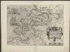
Zelandicarum insularum exactissima et nova descriptio
1 : 250000 auctore D. Jacobo a Daventria [Frans Hogenberg sculpsit] [S.l.] : [s.n.]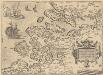
Zelandicarum Insularum Exactissima Et Nova Descriptio [Karte], in: Theatrum orbis terrarum, S. 189.
1 Karte aus Atlas Ortelius, Abraham Vrients, Jan Baptista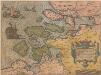
Zelandicarum Insularum Exactissima Et Nova Descriptio [Karte], in: Theatrum orbis terrarum, S. 50.
1 Karte aus Atlas Ortelius, Abraham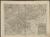
Zelandia
1 : 270000 [Johannes à Duetecum, Lucas à Duetecum fecerunt] Antwerpen : [Gerard de Jode]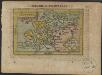
Zelandia
1 : 1200000 [Ambrosius en Ferdinand Arsenius engravers] [Antwerpen] : [Johan Baptist Vrients]
Seelandia
1 : 1900000 [Johann H. Seyfried del.] [Wilhelm Pfann sculps.] [Nürnberg] : [Johann Hoffmann]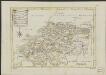
Nieuwe kaart van het departement van de Schelde en Maas
1 : 500000 C. Covens del. C. van Baarsel sculp. Te Amsterdam : bij Mortier Covens en Zoon
Isole Selandie
[intagliate da Girolamo Porro] [Padova] : [Jo. Baptista Conzatti]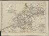
Esquisse géographique du cours de l'Escaut d'Anvers à la mer, de ses bouches, et de ses communications avec l'intérieur de la Flandre, de la Zelande et de la Hollande : Les Isles de Walcheren, Wolfertsdyk etc]
1 : 510000 par L.S. de La Rochette gravé par J. Turpin à La Haye. [London] : [Faden]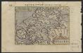
Selandia.
1 : 925000 [S.l.] : [s.n.]
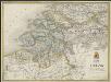
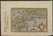
Brabantiae pars septentrionalis
1 : 172000 Brabantsko Hondius, Henricus H. Hondii
Brabantiae pars septentrionalis
1 : 170000 Brabantsko Hondius, Henricus sumptibus Henrici Hondy
Zeelandia Comitatus.
1 : 270000 Mollova mapová sbírka Schenk, Pieter Schenk, Peter I
Zeelandia Comitatus
1 : 270000 Mollova mapová sbírka Blaeu, Willem Janszoon
Zeelandia
1 : 860000 [Jodocus Hondius jr. engraver] [Amsterdam] : [Jodocus Hondius jr.]