Maps of Zeeland
Zelandia
1 : 270000 [Johannes à Duetecum, Lucas à Duetecum fecerunt] Antwerpen : [Gerard de Jode]
Zelandicarum Insularum Exactissima Et Nova Descriptio [Karte], in: Theatrum orbis terrarum, S. 189.
1 Karte aus Atlas Ortelius, Abraham Vrients, Jan Baptista
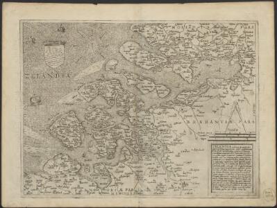
Zelandicarum insularum exactissima et nova descriptio
1 : 250000 auctore D. Jacobo a Daventria [Frans Hogenberg sculpsit] [S.l.] : [s.n.]
Zelandicarum insularum exactissima et nova descriptio
1 : 250000 auctore D. Jacobo a Daventria [Frans Hogenberg sculpsit] [S.l.] : [s.n.]
Zelandicarum insularum exactissima et nova descriptio
1 : 250000 auctore D. Jacobo a Daventria [Frans Hogenberg sculpsit] [S.l.] : [s.n.]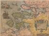
Zelandicarum Insularum Exactissima Et Nova Descriptio [Karte], in: Theatrum orbis terrarum, S. 50.
1 Karte aus Atlas Ortelius, Abraham
Zelandicarum insularum exactissima et nova descriptio
1 : 540000 auctore D. Jacobo à Daventria Johan Bussemecher excudit ; Henricus Nagell fecit. [Coln am Rhein] : [Buxemacher]
Zelandicarum insularum exactissima et nova descriptio
1 : 250000 auctore D. Jacobo a Daventria [Frans Hogenberg sculpsit] [S.l.] : [s.n.]
Zelandia
1 : 1120000 [Filips Galle engraver] [Antwerpen] : [Filips Galle]
A new map of Zealand : with the rivers Schelde, part of Holland, Flanders & Brabant, shewing the situation of the present dispute between the Emperor and the Dutch.
1 : 245000 London : Jno. Stockdale Picadilly
A new map of Zealand : with the rivers Schelde, part of Holland, Flanders & Brabant, shewing the situation of the Schelde.
1 : 245000 London : Jno. Stockdale Picadilly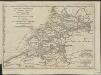
Esquisse géographique du cours de l'Escaut d'Anvers à la mer, de ses bouches, et de ses communications avec l'intérieur de la Flandre, de la Zelande et de la Hollande : Les Isles de Walcheren, Wolfertsdyk etc]
1 : 510000 par L.S. de La Rochette gravé par J. Turpin à La Haye. [London] : [Faden]
Zelandia Comitatus [Karte], in: Gerardi Mercatoris Atlas, sive, Cosmographicae meditationes de fabrica mundi et fabricati figura, S. 302.
1 Karte aus Atlas Mercator, Gerhard Montanus, Petrus
Kaart der overstroomingen in het Koningrijk der Nederlanden op de 3, 4, 5 en 6 Februarij 1825 : zuidelijk gedeelte.
1 : 450000 ['s-Gravenhage] : [J. Immerzeel jr.]
Zeelandia Comitatus. [Karte], in: Novus Atlas, das ist, Weltbeschreibung, Bd. 1, S. 405.
1 Karte aus Atlas Blaeu, Joan Blaeu, Willem Janszoon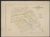
Zeelandia Comitatus. [Karte], in: Gerardi Mercatoris et I. Hondii Newer Atlas, oder, Grosses Weltbuch, Bd. 1, S. 459.
1 Karte aus Atlas Mercator, Gerhard und Hondius, Jodocus Jansson, Jan
Zeelandia Comitatus. [Karte], in: Theatrum orbis terrarum, sive, Atlas novus, Bd. 1, S. 437.
1 Karte aus Atlas Blaeu, Joan Blaeu, Willem Janszoon
Zeelandia Comitatus. [Karte], in: Le théâtre du monde, ou, Nouvel atlas contenant les chartes et descriptions de tous les païs de la terre, Bd. 1, S. 436.
1 Karte aus Atlas Blaeu, Willem Janszoon und Blaeu, Joan Blaeu, Willem Janszoon

Zeelandia Comitauts. [Karte], in: Novus atlas absolutissimus, Bd. 3, S. 188.
1 Karte aus Atlas Janssonius Offizin
Bijlage 11, uit: Eindverslag over de onderzoekingen en uitkomsten van den Dienst der Rijksopsporing van Delfstoffen in Nederland, 1903-1916
Annotatie: Met lit. opg Departement van Landbouw, Nijverheid en Handel. Dienst der Rijksopsporing van Delfstoffen ['s-Gravenhage : Martinus Nijhoff]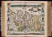
Comitatus Zelandiae nova descriptio anno 1657 / [Nicolaes Visscher]
1 : 200000 Annotatie: Origineel is Blad 47 in atlas factice; Met panorama's van Middelburg, Vlissingen en Zierikzee; Met kostuurfiguren naast de kaart; Annotatie geografische gegevens: West boven Visscher, Nicolaes (1618-1679) [Amsterdam : N. Visscher excudebat]
Zeelandia Comitatus
1 : 700000 Petrus Kaerius Flander caelavit aetatis 75. [Amsterdam] : [Johannes Janssonius]
Zeelandia Comitatus.
1 : 280000 [Amsterdam] : [Joannes Janssonius]
Naeukeurige nieuwe land-caert des graefschaps Zeeland.
1 : 160000 Te Leide : by Christiaen Vermey
ZEELANDIA Comitatus
[Amsterdam : Joan Blaeu]
Naeukeurige nieuwe land-caert des graefschaps Zeeland.
1 : 170000 Tot Middelburgh : by Johannes Meertens, en is tot Amsterdam te bekomen by Abraham van Someren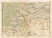
Zeeland en Noord-Brabant
1 : 300000 Brabantsko Seyffardt's boekhandel