Maps of Zeeland

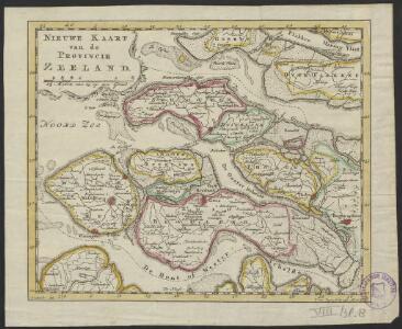
Nieuwe kaart van de provincie Zeeland
1 : 336000 J.C. Roeder del. J. van Jagen sculp. 1791. AEtat. 811⁄2. [Amsterdam] : [Johannes Allart]
Nieuwe kaart van de provintie Zeeland
1 : 185000 J.C. Roeder delin. J. van Jagen fecit 1792. AEtat 82. [Amsterdam] : [Johannes Allart]
Nieuwe kaart van de provintie Zeeland behoorende tot het Vaderlandsch woordenboek van J. Kok
1 : 200000 J.C. Roeder del. J. van Jagen fecit 1792. [S.l.] : [s.n.]
Nieuwe kaart van de provintie Zeeland, behoorende tot het Vaderlandsch woordenboek van J. Kok
1 : 185000 J.C. Roeder delin. J. van Jagen fecit 1792. AEtat 82. [Amsterdam] : [Johannes Allart]
Zelandia
1 : 440000 [Frans Hogenberg] [Köln] : [Hogenberg]
Kaart van het departement Zeeland met aanwyzing van deszelfs overstroomd gedeelte door den watervloed van 14 en 15 van Louwmaand 1808
1 : 170000 J.M. Verkuyl del. Dl. Veelwaard sculp. Haarlem : A. Loosjes Pzn
Kaarte van de provintie Zeeland en derselver stroomen
1 : 125000 naar de nieuwste waarneemingen. Te Amsterdam : by I. Covens & Zoon
Kaart van Zeeland.
1 : 175000 Te Amsterdam : by Isaak Tirion
Zeelandiae comitatus
1 : 110000 Nizozemsko Seutter, Matthäus per Matthaeum Seutter
Seeland
1 : 220000 [engraver: Ignez Albrecht] Wien : [F.J.J. von Reilly]
Carte de Comté de de [!] Zélande
1 : 250000 par le Sr. Robert geóg. ordin. du Roi gravé par Guill. Delahaye. [S.l.] : [s.n.]
Zeeland
1 : 166000 [F. Ottens s.f.] [Leeuwarden] : [Henrik Halma]
Comitatus Zelandiae.
1 : 340000 [Amsterdam] : [Hendrik de Leth]
La Zelande : suivant les nouvelles observations de Mess.rs de l'Academie Royale des Sciences, etc. augmentees de nouveau.
1 : 280000 A Leide : chez Pierre vander Aa
Comitatus Zelandiae tabula
1 : 110000 emendata a Frederico de Wit. Amstelodami : [Frederick de Wit]

Le Comté de Zeelande
1 : 135000 dressé sur les memoires les pl. nouveaux par le Sr. Sanson geographe ordinaire du Roy. A Paris : chez H. Jaillot, joignant les grands Augustins, aux deux globes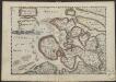
Zelandia comitatus.
1 : 420000 [Amsterdam etc.] : [Jacob Aertz. Colom]
Comitatus Zelandiae
1 : 120000 Mollova mapová sbírka Visscher, Nicolaes Schenk, Peter II
Comitatus Zelandiae tabula
1 : 110000 emendata a Frederico de Wit Amstelodami. [Amsterdam] : ex officina I. Cóvens et C. Mortier
Comitatus Zelandiae Novissima Delineatio [Karte], in: Novus atlas absolutissimus, Bd. 3, S. 191.
1 Karte aus Atlas Janssonius Offizin
Nova et accurata comitatus Zelandiae tabula
1 : 180000 multis locis correcta, atque edita per C. Allard. Amstelodami : apud Covens et Mortier
Nieuwe kaart van het graafschap Zeeland
1 : 115000 opgemaakt uit de beste kaarten en van misslagen gezuiverd door R. en J. Ottens. Amstelaedami : Reinerus et Josua Ottens
Le Comté de Zeelande : a l'usage de monseigneur le duc de Bourgogne.
1 : 115000 A Paris : chez H. Jaillot
Zelandiae comitatus novissima tabula
1 : 42000 delineata per Nicolaum I. Visscherum nunc autem emendata et aucta per R. Ottens. Amsterdam : Wed. Ottens en Zoone
Comitatus Zelandiae
1 : 350000 [F. Faugrant] [F. Desbruslins scripsit] [Leon de Francia] : [Jaime Certa]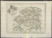
Zelande
1 : 380000 [G. Le Rouge] [Paris : [G. Le Rouge]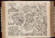
Comitatus Zelandiae novissima delineatio / per Nicolaum Visscher
1 : 200000 Annotatie: Origineel is Blad 48 in atlas factice Visscher, Nicolaes (1618-1679) [Amsterdam : C.J. Visscher excudebat]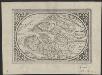
Zelandia comitatus
1 : 620000 [Abraham Goos engraver] [Amsterdam etc.] : [Abraham Goos etc.]