Maps of Zeeland

Nieuwe kaart van het graafschap Zeeland
1 : 115000 opgemaakt uit de beste kaarten en van misslagen gezuiverd door R. en J. Ottens. Amstelaedami : Reinerus et Josua Ottens
Le Comté de Zeelande : a l'usage de monseigneur le duc de Bourgogne.
1 : 115000 A Paris : chez H. Jaillot
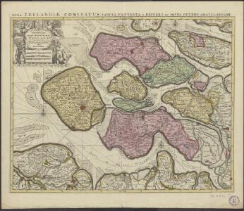
Nova et accurata comitatus Zelandiae tabula
1 : 180000 multis locis correcta, atque edita per C. Allard. Amstelodami : apud Covens et Mortier
Comitatus Zelandiae tabula
1 : 110000 emendata a Frederico de Wit Amstelodami. [Amsterdam] : ex officina I. Cóvens et C. Mortier
Comitatus Zelandiae tabula
1 : 110000 emendata a Frederico de Wit. Amstelodami : [Frederick de Wit]
Comitatus Zelandiae
1 : 350000 [F. Faugrant] [F. Desbruslins scripsit] [Leon de Francia] : [Jaime Certa]
Comitatus Zelandiae Novissima Delineatio [Karte], in: Novus atlas absolutissimus, Bd. 3, S. 191.
1 Karte aus Atlas Janssonius Offizin
Zeelandiae Comitatus novissima et accuratissima delineatione mappa geographica
1 : 110000 representatus per Tob. Conrad Lotter ... [Augsburg] : T.C. Lotter
Comitatus Zelandiae novissima delineatio / per Nicolaum Visscher
1 : 200000 Annotatie: Origineel is Blad 48 in atlas factice Visscher, Nicolaes (1618-1679) [Amsterdam : C.J. Visscher excudebat]

Comitatus Zelandiae tabula
1 : 120000 Nizozemsko Wit, Frederick de a Frederico de Witt
Contado di Zelanda
1 : 146000 [Vincenzo Coronelli] [S.l.] : [s.n.]
Le Comté de Zeelande
1 : 135000 dressé sur les memoires les pl. nouveaux par le Sr. Sanson geographe ordinaire du Roy. A Paris : chez H. Jaillot, joignant les grands Augustins, aux deux globes
Nieuwe kaart van Zeeland.
1 : 850000 Te Rotterdam : by A. van Zwaamen
Kaart van het departement Zeeland met aanwyzing van deszelfs overstroomd gedeelte door den watervloed van 14 en 15 van Louwmaand 1808
1 : 170000 J.M. Verkuyl del. Dl. Veelwaard sculp. Haarlem : A. Loosjes Pzn
Kaart van Zeeland.
1 : 175000 Te Amsterdam : by Isaak Tirion
Zelandiae comitatus novissima tabula
1 : 42000 delineata per Nicolaum I. Visscherum nunc autem emendata et aucta per R. Ottens. Amsterdam : Wed. Ottens en Zoone
Zeeland
1 : 166000 [F. Ottens s.f.] [Leeuwarden] : [Henrik Halma]
Zelandiae typus.
1 : 270000 [Antwerpen] : [Christophe Plantin]
Zelande
1 : 380000 [G. Le Rouge] [Paris : [G. Le Rouge]
Comitatus Zelandiae.
1 : 340000 [Amsterdam] : [Hendrik de Leth]
Zeelandiae comitatus
1 : 140000 Nizozemsko Lotter, Tobias Conrad Tob. Conrad Lotter
Comitatus Zelandiae novissima delineatio
1 : 120000 per Nicolaum Visscher Lies f. [Amsterdam] : nunc apud Pet: Schenk Jun:
Carte des bouches de L'Escaut
1 : 200000 dessinée et gravée d'après la carte des côtes des Pays bas de Mr. Beautemps Beaupré par Ambroise Tardieu. [Paris] : [Treuttel et Würtz]
Kaart van de provincie Zeeland, in hare tegenwoordige gesteldheid met al de bedijkingen, kanalen, afwateringen, kunstwegen, telegraaflijnen enz.
1 : 80000 uit goede bronnen en gedane opnemingen in de jaren 1856-1859 te zamen gesteld ... door A. Magielse & J.J. Brandt ... T. W. den Doop sculpc. [Middelburg] : T.P. Roest
Zelandia
1 : 440000 [Frans Hogenberg] [Köln] : [Hogenberg]
Zeelandiae comitatus
1 : 110000 Nizozemsko Seutter, Matthäus per Matthaeum Seutter
Kaarte van de provintie Zeeland en derselver stroomen
1 : 125000 naar de nieuwste waarneemingen. Te Amsterdam : by I. Covens & Zoon
Carte de Zelande
1 : 620000 [Christophe Tassin] [Paris] : [Martin Gobert etc.]