Maps of Saint Lawrence County

Ogdensburg
1 : 250000
Ogdensburg
1 : 250000
Ogdensburg
1 : 250000
Ogdensburg
1 : 250000
Ogdensburg
1 : 250000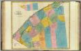
St. Lawrence County.
1 : 151000 Burr, David H., 1803-1875
St. Lawrence County.
1 : 158400 Bien, Joseph Rudolf
Franklin County.
1 : 151000 Burr, David H., 1803-1875
Watertown Business Directory. ; North Watertown [Village]; Juhelville [Village]
from New topographical atlas of Jefferson Co., New York : From actual surveys / by S.N. & D.G. Beers and assistants.
Outline plan of Franklin Co.
from Atlas of Franklin County, New York. : From actual surveys and official records.
Franklin County.
1 : 158400 Bien, Joseph Rudolf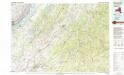
Gouverneur
1 : 100000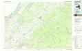
Gouverneur
1 : 100000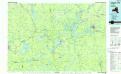
Tupper Lake
1 : 100000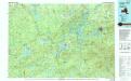
Tupper Lake
1 : 100000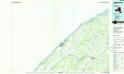
Ogdensburg
1 : 100000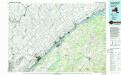
Ogdensburg
1 : 100000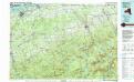
Massena
1 : 100000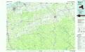
Massena
1 : 100000
Russell [Township]
from New topographical atlas of St. Lawrence County, N.Y. : from actual surveys / by S.N. and D.G. Beers and assistants.
Theresa [Township]
from New topographical atlas of Jefferson Co., New York : From actual surveys / by S.N. & D.G. Beers and assistants.
Antwerp. [Township]
from New topographical atlas of Jefferson Co., New York : From actual surveys / by S.N. & D.G. Beers and assistants.
Waddington [Township]
from New topographical atlas of St. Lawrence County, N.Y. : from actual surveys / by S.N. and D.G. Beers and assistants.
Russell, Saint Lawrence County, New York.
1 : 63360 Beers, D.G.
Depeyster [Village]; De Peyster Business Directory. ; De Peyster [Township]
from New topographical atlas of St. Lawrence County, N.Y. : from actual surveys / by S.N. and D.G. Beers and assistants.
Oswegatchie [Township]
from New topographical atlas of St. Lawrence County, N.Y. : from actual surveys / by S.N. and D.G. Beers and assistants.
Potsdam [Township]
from New topographical atlas of St. Lawrence County, N.Y. : from actual surveys / by S.N. and D.G. Beers and assistants.
Morristown [Township]; Edwards Business Directory. ; Brier Hill [Village]
from New topographical atlas of St. Lawrence County, N.Y. : from actual surveys / by S.N. and D.G. Beers and assistants.
Canton [Township]
from New topographical atlas of St. Lawrence County, N.Y. : from actual surveys / by S.N. and D.G. Beers and assistants.

