Maps of Clark County

Kahoka SE
1 : 24000
Kahoka SE
1 : 24000
Kahoka
1 : 125000
Kahoka
1 : 125000
Kahoka
1 : 125000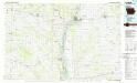
Keokuk
1 : 100000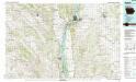
Keokuk
1 : 100000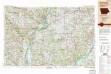
Burlington
1 : 250000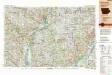
Burlington
1 : 250000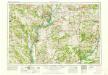
Burlington
1 : 250000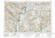
Burlington
1 : 250000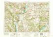
Burlington
1 : 250000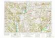
Burlington
1 : 250000
[Coteau des prairies, M'dewakaton country, Warpekutey country, Winebago Indian country, Iowa Territory; middle right.] / by J.N. Nicollet, made in the years 1836, 37, 38, 39 & 40 ; assisted in 1838, 39 & 40 by Lieut. J.C. Frémont of the Corps of Topog...
From Map of the hydrographical basin of the upper Mississippi River : from astronomical and barometrical observations, surveys and information
Iowa.
from The cerographic atlas of the United States. By Sidney E. Morse, A.M., and Samuel Breese, A.M.
AutoTrails Map, Illinois, Western Indiana, Southeast Iowa, Northeast Missouri.
1 : 783000 Rand McNally and Company
From W. boundary of Missouri to mouth of Trap Creek.
1 : 760320 Gunnison, J.W.
Map of the Settled Part of Wisconsin Territory.
1 : 1140480 Young, James H.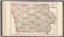
Iowa.
1 : 937000 Gray, Ormando Willis
Iowa.
1 : 1700000 Tanner, Henry S.
Iowa.
1 : 1500000 Colton, G.W.
Illinois.
1 : 1387000 Hammond, C.S.
Illinois.
1 : 1300000 Rand McNally and Company
Sectional Map of Illinois ... by D.W. Ensign, Published by Thompson and Everts, Geneva, Illinois, 1871.
1 : 887040 Thompson and Everts
Iowa And Nebraska.
1 : 1520640 Johnson, A.J.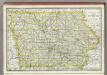
Iowa.
1 : 2300000 Rand McNally and Company
Illinois.
Rand McNally and Company
208. Illinois. The World Atlas.
1 : 1250000 USSR (Union of Soviet Socialist Republics).
Illinois.
1 : 1045440 Colton, G.W.

