Maps of San Bernardino County

Mescal Creek
1 : 24000
Mescal Creek
1 : 24000
Mescal Creek
1 : 24000
Mescal Creek
1 : 24000
Mescal Creek
1 : 24000
Boneyard Canyon
1 : 24000
Boneyard Canyon
1 : 24000
Boneyard Canyon
1 : 24000
Mescal Creek
1 : 24000
Mescal Creek
1 : 24000
Mescal Creek
1 : 24000
San Antonio
1 : 62500
San Antonio
1 : 62500
San Antonio
1 : 62500
San Antonio quadrangle showing San Andreas Rift.
1 : 62500 U.S. Geological Survey
San Antonio
1 : 62500
San Antonio
1 : 62500
San Antonio
1 : 62500
San Antonio
1 : 62500
San Antonio
1 : 62500
San Antonio
1 : 62500
San Antonio
1 : 62500
Swarthout
1 : 24000
Swarthout
1 : 24000
Swarthout
1 : 24000
San Bernardino
1 : 100000
Map Showing State Highway System (California), 1932.
1 : 1463040 California Department of Public Works, Division of Highways
Location map, Los Angeles County airports, showing motion picture studios
1 : 1220000 Relief shown by hachures and spot heights. Includes text. Regional Planning Commission, County of Los Angeles, California [Los Angeles, Calif.] The Commission.
The old Spanish and Mexican ranchos of Los Angeles County
1 : 1307000 Pictorial map. Relief shown by hachures. Title Insurance and Trust Company (1893-1968) The Company, (Los Angeles : Young & McCallister)
San Bernardino
1 : 250000
San Bernardino
1 : 250000
San Bernardino
1 : 250000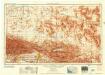
San Bernardino
1 : 250000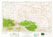
San Bernardino
1 : 250000