Maps of San Bernardino County

Maps of San Bernardino County

$title$

San Antonio

1 : 62500
$title$

San Antonio

1 : 62500
$title$

San Antonio

1 : 62500
$title$

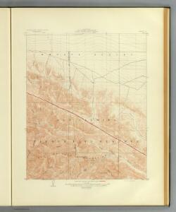
San Antonio quadrangle showing San Andreas Rift.

1 : 62500 U.S. Geological Survey
$title$

San Antonio

1 : 62500
$title$

San Antonio

1 : 62500
$title$

San Antonio

1 : 62500
$title$

San Antonio

1 : 62500
$title$

San Antonio

1 : 62500
$title$

San Antonio

1 : 62500
$title$

San Antonio

1 : 62500
$title$

Telegraph Peak

1 : 24000
$title$

Mount San Antonio

1 : 24000
$title$

Telegraph Peak

1 : 24000
$title$

Telegraph Peak

1 : 24000
$title$

Telegraph Peak

1 : 24000
$title$

Telegraph Peak

1 : 24000
$title$

Mount San Antonio

1 : 24000
$title$

Mount San Antonio

1 : 24000
$title$

Mount San Antonio

1 : 24000
$title$

Mount San Antonio

1 : 24000
$title$

Telegraph Peak

1 : 24000
$title$

Mount San Antonio

1 : 24000
$title$

Phelan

1 : 24000
$title$

Mescal Creek

1 : 24000
$title$

Mescal Creek

1 : 24000
$title$

Phelan

1 : 24000
$title$

Phelan

1 : 24000
$title$

Mescal Creek

1 : 24000
$title$

Phelan

1 : 24000
$title$

Mescal Creek

1 : 24000
$title$

Phelan

1 : 24000
$title$

Phelan

1 : 24000
$title$

Phelan

1 : 24000
$title$

Mescal Creek

1 : 24000
© MapTiler © OpenStreetMap contributors
How does it work?
These instructions will show you how to find historical maps online.
Getting started
Type the place name in the search box to find the exact location. You can further adjust the search by zooming in and out.
Zoom
Zoom in and out with the buttons or use your mouse or touchpad natively.
Exact Area tool
Click here and draw a rectangle over the map to precisely define the search area.
Set filters
Narrow your search with advanced settings, such as Years (from/to), Fulltext, Publisher, etc.
Results
See the results of your search on the right side. You can scroll down to find more maps of this location.
?

Download OldMapsOnline Mobile