Maps of Chautauqua County

South Ripley
1 : 24000
South Ripley
1 : 24000
South Ripley
1 : 24000
Clymer
1 : 62500
Clymer
1 : 62500
Clymer
1 : 62500
Clymer
1 : 62500
Clymer
1 : 62500
Clymer
1 : 62500
Clymer
1 : 62500
Clymer
1 : 62500
Clymer
1 : 62500
Westfield [Township]; Barcelona [Township]
from New topographical atlas of Chautauqua County, New York. From actual surveys especially for this atlas.
Cassadaga [Village]; Clymer Hill [Village]; Cassadaga Business Directory.; French Creek [Township]
from New topographical atlas of Chautauqua County, New York. From actual surveys especially for this atlas.
Chautauque County.
1 : 151000 Burr, David H., 1803-1875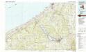
Jamestown
1 : 100000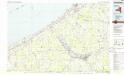
Jamestown
1 : 100000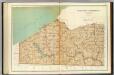
Chautauqua, Cattaraugus counties.
1 : 158400 Bien, Joseph Rudolf
Erie, Crawford, Venango counties.
1 : 300000 Gray, Ormando Willis; Walling, H. F.
Buffalo
1 : 250000
Buffalo
1 : 250000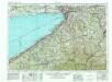
Buffalo
1 : 250000
Buffalo
1 : 250000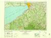
Buffalo
1 : 250000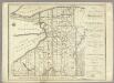
Map of Morris's Purchase or West Geneseo In the State of New York.
1 : 336000 Ellicott, Joseph & B.
Map of Morris's Purchase or West Geneseo in the state of New York : exhibiting part of the Lakes Erie and Ontario, the Straights of Niagara ...
1 : 336000 Ellicott, Joseph Holland Land Co.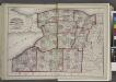
"Niagara, Erie, Chautauqua, Cattaraugus, Orleans, Genesee, Wyoming, Allegany, Monroe, and Livingston Counties"
from New topographical atlas and gazetteer of New York, comprising a topographical view of the several counties of the state, ... including ... map of the United States and territories ... Compiled from the latest astronomical observations, official surveys and records of the United States and territories ...
Pennsylvania (western part).
1 : 585000 Hammond, C.S.
Pennsylvania, Western Section.
1 : 539000 Rand McNally and Company

