Maps of Surry County

Runnymede
1 : 24000
Runnymede
1 : 24000
Runnymede
1 : 24000
Runnymede
1 : 24000
Runnymede
1 : 24000
Surry
1 : 62500
Surry
1 : 62500
Surry
1 : 62500
Yorktown To Williamsburg.
1 : 63360 Abbot, Henry L.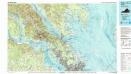
Williamsburg
1 : 100000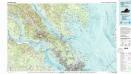
Williamsburg
1 : 100000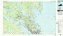
Williamsburg
1 : 100000
Carta particolare della Virginia Vecchia e Nuoua : la longitune comica da l'Isola di Pico di Asores : d'America carta, III / A.F. Lucini fece.
from Charts and maps
Vicinity of Richmond.
1 : 180000 Johnson, A.J.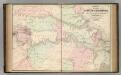
Vicinity of Richmond.
1 : 180000 Johnson, A.J.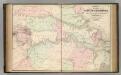
Vicinity of Richmond.
1 : 180000 Johnson, A.J.
Map of the seat of war. Published by T.A. Burke
1 : 800000 Howell, R. H.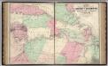
Vicinity of Richmond, and Peninsular Campaign in Virginia (American Civil War).
1 : 189000 Johnson, A.J.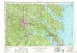
Richmond
1 : 250000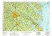
Richmond
1 : 250000
Richmond
1 : 250000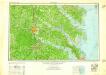
Richmond
1 : 250000
Richmond
1 : 250000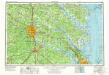
Richmond
1 : 250000
A draught of Virginia from the Capes to York in York River ....
from English pilot. The fourth book.
Central Virginia showing Lieut Gen'l U.S. Grant's Campaign and Marches.
1 : 350000 United States. War Dept. Engineer Bureau
Maryland.
1 : 1774080 Scott, Joseph
Composite: New Map Of The Peninsula Embracing Delaware And The Eastern Shores Of Maryland And Virginia
1 : 346480 MacCormac, Walter S.
Lloyd's Military Campaign Charts: North Carolina Coast
Lloyd's Military Campaign Charts, showing the principal places of interest, compiled from official data by Gen. E.L. Viele and C. Haskins. Published under the auspices of the American Geographical and Statistical Society. North Carolina Coast.

