Maps of Switzerland

Carte physique et politique de la Suisse
1 Karte : Kupferdruck ; 31 x 42 cm Mentelle; Chanlaire; Blondeau chez les auteurs P. G. Chanlaire rue Geoffroy-Langevin no. 328, et E. Mentelle cour du Louvre no. 7
Novissima Foederatorum HELVETIORUM Tabula
1 : 2600000 Švýcarsko
Switzerland and the county of the Grisons, wherein is described the XIII Switz Cantons with their allies & c
1 : 760000 humbly inscrib'd to [...] the Marquiss of Harold & c. rev. by J. Senex [London] : [Brown]
Carte ancienne de la Suisse
1 Karte : Kupferdruck ; 19 x 19 cm, Bildgrösse 36 x 45 cm Châtelain s.n.
Geographisches Verzeichniss der merkwürdigsten Orte in der Schweiz
1 : 700000 Körner, Heinrich ; Holzhalb, Hans Rudolf [s.n.]
Nuova carta dei XIII cantoni degli Svizzeri insieme coi loro alleati e sudditi
1 : 950000 1 Karte [Thomas Salmon] [Albrizzi], [Venezia]
Reliefkarte der Schweiz
Originaltitel: Nova Helvetiae Tabula geographica Illustrissimis et Potentissimis Cantonibus et Rebuspublicis Reformatae Religionis Tigurinae, Bernensi, Glaronensi, Basilensi, Scaphusianae, Abbatis cellanae. Scheuchzer, Johann Jakob (1672-1733), Arzt und Naturforscher, von Zürich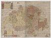
Karte der Schweiz von 1657
1 : 500000 Originaltitel: Helvetiae, Rhaetiae et Valesiae caeterorumque Confoederatorum ut et finitimorum Populorum. Tabula Geographica et Hydrographica nova et exacta. Neudruck (mittels revidierter und teilweise nachgestochener Kupferplatten) der von Hans Conrad Gyger, andere Schreibweisen: Geiger, Geyger, (1599-1674), Kartograf, Ingenieur und Amtmann des Amts Kappelerhof, von Zürich, gezeichneten und von Conrad Meyer (1618-1689), Maler, Zeichner und Radierer, von Zürich, gestochenen Originalkarte. Mit (am linken und rechten Bildrand) farbigen Wappen der Dreizehnörtigen Eidgenossenschaft sowie der elf Zugewandten Orte und mit (am linken unteren Bildrand) den Wappen der neuen Gemeinen Herrschaften Baden, Frauenfeld, Freiämter, Sargans, Rheintal, Lugano, Locarno, Mendrisio und Meinthal. Mit einer Erklärung der Zeichen. Karte aus zwei zusammensetzbaren Blättern (zwei Kupferdruckplatten). Gyger, Hans Georg (1627-1687), Maler und Amtmann des Klosteramts Küsnacht, von Zürich
Die Schweiz.
1 : 800000 Stein, Christ. Gottfr. Dan.
Nova Helvetiae tabula geographica illustrissimis et potentissimis cantonibus et rebuspublicis reformatae religionis Tigurinae, Bernensi, Glaronensi, Basiliensi, Scaphusianae, Abbatis Cellanae
1 : 230000 1 Karte auf 4 Bl. dominis suis clementissimis humillime dicata a Ioh. Iacobo Scheuchzero Tigurino ; Ioh. Melch. Füsslin ornamenta pinx. ; Ioh. Henr. Huber et Eman. Schalch sculps. [Verlag nicht ermittelbar], [Zürich]
Die Schweiz.
1 : 1020000 Flemming, Carl

Carte de la Suisse où sont les treize cantons, leurs alliés, et leurs sujets
1 Karte dressée sur les meilleurs auteurs et d'après des observations faites sur les lieux et publiés par François Grasset ; Aldring sculp. ; E. Dussy scripsit Grasset, Lausanne
Kleine offizielle Eisenbahnkarte der Schweiz
1 : 500000 Mit Legenden in deutscher und französischer Sprache. Eidgenössisches Post- und Eisenbahndepartement, Bern Geograph. artist. Anstalt Kümmerly und Frey, Bern
Nova et accuratissima Helvetiae foederatarumque cum ea, nec non subditarum, regionum tabula
1 Karte primum composita per de l'Isle, nunc vero aucta & emendata = Les cantons suisses, leurs alliés & pays sujets / composée par Guillaume de l'Isle, corrigée & augmentée le plus nouvelles chez I.B. Elwe, Amsterdam
Tourist map of Switzerland
1 : 600000 Evropa Swiss national tourist office
Automobil-Karte der Schweiz
1 : 400000 Švýcarsko Kümmerly & Frey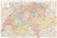
Reise- und Verkehrskarte der Schweiz
1 : 400000 Švýcarsko A. Meissner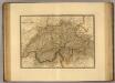
Suisse.
1 : 745000 Picquet, C.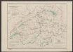
Übersichtskarte des schweizerischen Pegel und Witterungsstationennetzes
1 : 600000 Topogr. Anstalt v. Wurster, Randegger & Cie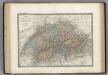
Suisse.
1 : 740000 Levasseur, E.
Helvetia
1 : 1700000 1 Karte [von Heinrich Heidegger] [bey Orell, Füssli und Compagnie], [Zürich]
Nova et accuratissima Helvetiae foederatarumque cum ea, nec non subditarum, regionum tabula
1 Karte primum composita per de l'Isle, nunc vero aucta & emendata = Les cantons suisses, leurs alliés & pays sujets / composée par Guillaume de l'Isle, corrigée & augmentée, le plus nouvelles chez Elwe & Langeveld, Amsterdam
Sud-West Deutschland Und Schweiz. Sudlicher Theil.
1 : 925000 Vogel, C.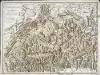
Carte générale de la Suisse et de ses environs
1 Karte : Kupferdruck ; 40 x 56 cm Monti; Buache chez F. Monti
Switzerland.
1 : 1000000 Colton, G.W.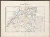
Historischer Atlas der Schweiz
1536 - 1650 Mandrot, Louis-Alphonse de Deutsche Buchhandlung von J. Kessmann
Nova totius Helvetiae tabula exhibens ejus XIII pagos, cantones dictos, unâ cùm sociorum ditionibus atque communium subditorum provinciis
1 Karte adornata et aeri incisa a Benedicto Roth Bernensi 1730 [Verlag nicht ermittelbar], [Erscheinungsort nicht ermittelbar]
Carte de la Suisse où sont les treize cantons, leurs alliés, et leurs sujets
1 Karte dressée sur les meilleurs auteurs et d'après des observations faites sur les lieux et publiés par François Grasset ; Aldring sculp. ; E. Dussy scripsit Grasset, Lausanne


