Maps of Switzerland

Novissima et accuratissima Helvetiæ Rhætiæ, Valesiæ et partis Sabaudiæ tabula
1 Karte : Kupferdruck ; 48 x 56 cm Ottens; Ottens ex officina R. et I. Ottens
Switzerland
1 : 652000 Švýcarsko C.S. Hammond
General-Charte von der Schweiz
1 : 575000 1 Karte nach den vorzüglichsten Hilfsmitteln bearbeitet und der neuesten Eintheilung begränzt von C.F. Weiland Verlag des Geograph. Instituts, Weimar
Regenkarte der Schweiz
1 : 1000000 Billwiller, Robert Wurster & Randegger
Karte der Schweiz für Schulen
1 : 800000 Leuzinger, Rudolf Dalp'sche Buch- & Kunsthandlung (Carl Schmid)
Atlas über die Entwicklung von Industrie und Handel der Schweiz in dem Zeitraume vom Jahr 1770 bis zum Jahr 1870
1 : 500000 Orientierungsblatt Industrie Schweiz Wartmann, Hermann Wurster Randegger & Co.
Officielle Uebersichtskarte der Schweiz. Eisenbahnen vom Monat Januar 1878
1 : 700000 1 Karte Schweiz. Eisenbahn- & Handelsdepartement Orell Füssli, Zürich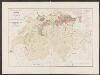
Atlas über die Entwicklung von Industrie und Handel der Schweiz in dem Zeitraume vom Jahr 1770 bis zum Jahr 1870
1 : 500000 Schweiz um das Jahr 1820 Wartmann, Hermann Wurster Randegger & Co.
Helvetia cum Subditis & Sociis Helvet. ad usum temporis nostri
1 : 1100000 Mollova mapová sbírka Weigel, Christoph Kauffer, Michael Weigel, Christoph I.
[Historischer Atlas der schweizerischen Geschichte]
1 : 1000000 Entwicklung der Eidgenossenschaft 1436 - 1499 Steiner, J. Wurster, Randegger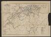
Eisenbahnkarte der Schweiz
1 : 500000 Gross, Rudolf Verlag Caesar Schmidt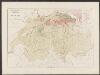
Atlas über die Entwicklung von Industrie und Handel der Schweiz in dem Zeitraume vom Jahr 1770 bis zum Jahr 1870
1 : 500000 Schweiz um das Jahr 1770 Wartmann, Hermann Wurster Randegger & Co.
<<Die>> Urschweiz 1315
1 : 1700000 1 Karte Kartogr. Anstalt Hofer & Co., Zürich
Karte der Schweiz
1 : 400000 Leuzinger, Rudolf ; Hoven, Georg Christian von chez J. Dalp (C. Schmid)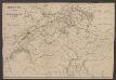
Eisenbahnkarte der Schweiz
1 : 800000 Leuzinger, Rudolf J.A. Preuss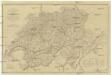
Carte physique et routiere de la Suisse
1 : 700000 Švýcarsko Starling, Thomas Virtue, George George Virtue
Atlas über die Entwicklung von Industrie und Handel der Schweiz in dem Zeitraume vom Jahr 1770 bis zum Jahr 1870
1 : 500000 1 Atlas ([3], VIII Bl.) im Auftrage der schweizerischen Commission für die additionellen Ausstellungen in Wien, bearbeitet von Dr. Hermann Wartmann Wurster Randegger & Co., Winterthur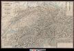
Sechste Wandkarte der Schweiz in 8 Blättern
1 : 200000 1 Karte in 4 Teilen H. Keller jun. ; Lith. von R. Leuzinger chez Hri. Keller, Zürich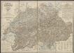
Karte der Schweiz
1 : 450000 Gross, Rudolf ; Graf, Josef ; Spengler, C. Rixinger, F.X. Ch. Beyel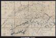
Wandkarte der Schweiz
1 : 210000 1 Karte in 8 Teilen gezeichnet und hrsg. von Heinrich Keller in Zürich = Carte de la Suisse : avec les plans des cheflieux des 22 Cantons pour les écoles / dessinée et publiée par Henri Keller à Zurich [Heinrich Keller], Zürich
Atlas über die Entwicklung von Industrie und Handel der Schweiz in dem Zeitraume vom Jahr 1770 bis zum Jahr 1870
1 : 500000 Schweiz um das Jahr 1870 Wartmann, Hermann Wurster Randegger & Co.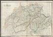
Switzerland
A new general atlas of modern geography, consisting of a complete collection of maps of the four quarters of the globe Wyld, James James Wyld
Novissima et accuratissima Helvetiæ, Rhætiæ, Valesiæ, et partis Sabaudiæ tabula
1 Karte : Kupferdruck ; 47 x 56 cm Lotter apud Tobiam Conr: Lotter chalcogr
Novissima et accuratissima Helvetiæ, Rhætiæ, Valesiæ, et partis Sabaudiæ tabula
1 Karte : Kupferdruck ; 47 x 56 cm Wolff ex officina Ierem: Wolfii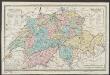
Carte de la Suisse à l'usage des écoles Suisses
1 : 850000 Keller, Heinrich bey Heinrich Keller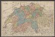
Suisse
1 : 800000 Keller, Heinrich Hch. Keller's geogr. Verlag, untere Zäune 23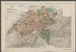
[Historischer Atlas der schweizerischen Geschichte]
1 : 1000000 Bauernkrieg 1653 Steiner, J. Wurster, Randegger
General-Charte der Schweiz
1 : 1200000 1 Karte entworfen u. gestochen v. J. Scheurmann bey Orell, Füssli & Compagnie, Zürich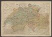
Polit. Einteilung der XIII ört. Eidgenossenschaft vor ihrem Umsturze im Jahre 1798
1 : 600000 Früh, J.U. Schlumpf
Die Eÿdgnoschafft mit dero Grentzen
1 Karte : Kupferdruck ; 12 x 16 cm Gyger; Meyer s.n.
Die Eÿdgnoschafft mit dero Grentzen
1 Karte : Kupferdruck ; 13 x 18 cm Gyger; Meyer s.n.


