Maps of Switzerland
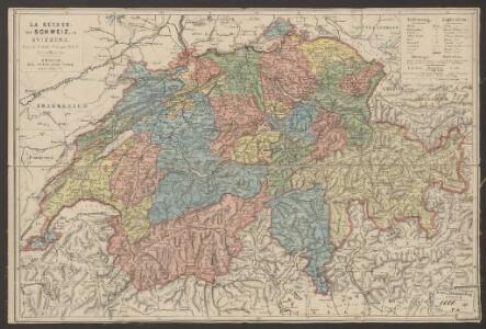
Suisse
1 : 800000 Keller, Heinrich Hch. Keller's geogr. Verlag, untere Zäune 23
Helvetia cum finitimis regionibus confoederatis. [Karte], in: Gerardi Mercatoris Atlas, sive, Cosmographicae meditationes de fabrica mundi et fabricati figura, S. 261.
1 Karte aus Atlas Mercator, Gerhard Montanus, Petrus
Eisenbahnkarte der Schweiz
1 : 800000 Leuzinger, Rudolf J.A. Preuss
Nouvelle carte itinéraire
1 : 700000 Švýcarsko Weiss, H. Bourgdorfer, J. J. J.J. Bourgdorfer
Eisenbahnkarte der Schweiz
1 : 500000 Gross, Rudolf Verlag Caesar Schmidt
[Historischer Atlas der schweizerischen Geschichte]
1 : 1000000 Entwicklung der Eidgenossenschaft 1351 - 1415 Steiner, J. Wurster, Randegger
General-Charte der Schweiz
1 : 1200000 1 Karte entworfen u. gestochen v. J. Scheurmann bey Orell, Füssli & Compagnie, Zürich
Suisse.
1 : 750000 Vivien St Martin, L.
[Historischer Atlas der schweizerischen Geschichte]
1 : 1000000 Entwicklung der Eidgenossenschaft 1501 - 1798 Steiner, J. Wurster, Randegger
Wandkarte der Schweiz
1 : 210000 1 Karte in 8 Teilen gezeichnet und hrsg. von Heinrich Keller in Zürich = Carte de la Suisse : avec les plans des cheflieux des 22 Cantons pour les écoles / dessinée et publiée par Henri Keller à Zurich [Heinrich Keller], Zürich
Karte der Schweiz für Schulen
1 : 800000 Leuzinger, Rudolf Verlag der J. Dalp'schen Buch & Kunsthandlung (Carl Schmid)
Carte de la Suisse à l'usage des écoles Suisses
1 : 850000 Keller, Heinrich bey Heinrich Keller
Novissima et accuratissima Helvetiae, Rhaetiae, Valesiae, et partis Sabaudiae tabula.
Amsterdam : ex officina R. & J. Ottens
[Historischer Atlas der schweizerischen Geschichte]
1 : 1000000 Krieg von 1847 Steiner, J. Wurster, Randegger
Carte pour l'histoire ancienne de l'Helvétie
1 Karte auf 4 Bl. [Charles Guillaume Loys de Bochat] ; [Jean Philippe Loys de Cheseaux] chés Bousquet, Lausanne
Petite carte de la Suisse pour les écoles
1 : 800000 1 Karte gezeichnet und herausgegeben von H. Keller Heinrich Keller, untere Zäune No. 367, Zürich
Carte de Suisse
1 Karte dressé sur les memoires de Merveilleux par Guillaume de l'Isle chez l'auteur sur le Quay de l'Horloge, Paris
[Kaart], uit: Carte scolaire de la Suisse = Schulkarte der Schweiz / H. Kümmerly
1 : 600000 titelvariant: Schulkarte der Schwei; Annotatie: Op omslag (verso): statische gegevens; Annotatie geografische gegevens: Inzet: Politische Übersicht = Carte politique = Carta politica. - Schaal 1:2.750.000 H. Kümmerly Bern : Kümmerly & Frey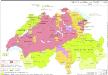
Innerer Aufbau der Schweiz 1648
Schweiz Verwaltungsgliederung Kunz, Andreas ; Moeschl, Joachim Robert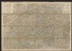
Karte der Schweiz
1 : 400000 Leuzinger, Rudolf J. Dalp (C. Schmid)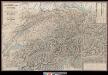
Sechste Wandkarte der Schweiz in 8 Blättern
1 : 200000 1 Karte in 4 Teilen H. Keller jun. ; Lith. von R. Leuzinger chez Hri. Keller, Zürich
Switzerland.
1 : 1457280 Lucas, Fielding Jr.
Hypsometrische Karte der Schweiz
1 : 1200000 Wurster u. Comp.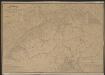
Postkarte der schweizerischen Eidgenossenschaft
1 : 300000 Stengel, Johann Rudolf ; Mohr, Ernst Rudolf Topogr. Anstalt v. J. Wurster u. Comp.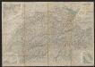
Roadmap of Switzerland
1 : 355000 Müllhaupt, Hans Heinrich ; Bressanini, Rinaldo ; Leuthold, Hans Felix Leuthold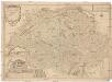
Les Suisses leurs sujets et leurs alliez
1 : 500000 Švýcarsko Fer, Nicolas de Dant Dant
Officielle Uebersichtskarte der Schweiz. Eisenbahnen vom Monat Januar 1878
1 : 700000 1 Karte Schweiz. Eisenbahn- & Handelsdepartement Orell Füssli, Zürich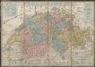
Petite carte de la Suisse pour les écoles
1 : 800000 Keller, Heinrich [H. Keller'sgeogr. Verlag]
[Recto], uit: Reiskaart van Zwitserland / kartografie: Kümmerly & Frey
1 : 600000 titelvariant: Kaart van Zwitserland; Annotatie: Omslagtitel: Kaart van Zwitserland Kümmerly + Frey, Bern Zürich [etc.] : Zwitsersche Verkeerscentrale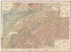
Geologische Karte der Schweiz
1 : 500000 Švýcarsko Heim, Albert Leuzinger, Rudolf Schweiz. geologische Commission