Maps of Normandy
Carte de la république de France, no. 1
1 Blatt : 41 x 59 cm s.n.
English Channel. Pergamon World Atlas.
1 : 1250000 Polish Army Topography Service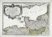
Premiere feuille contenant la Bretagne, la Normandie, le Maine et perche
1 Blatt : 39 x 56 cm Bourgoin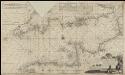
Nieuwe groote verbêterde en corekte gelijkgradige paskaart van het Canaal tusschen Engeland en Vrankerijk, als mede het verkeerde Canaal, met de droogtens, dieptens en de waatergetijden &a =
1 : 675000 naaukeurich opgestelt en in't ligt gebragt door [...] Chfel. Middagten Joan van Luchtenburch [...] delineavit et schulpcit [!] Amsterdam : bij J. Loots, boek en zeekaart verkooper in de Nieuwebrugsteeg in de Jonge Lootsman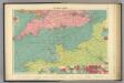
English Channel.
1 : 1500000 Philip, George
Neueste Generalkarte von Frankreich, 1
1 Blatt : 54 x 77 cm F.A. Schrämbl
British Channel.
1 : 790000 Thomson, John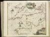
[130][133] Pascaert van 't Canaal tusschen Engeland en Vranckryck, uit: Atlas sive Descriptio terrarum orbis
Annotatie: Gedigitaliseerde versie. Amsterdam. Heiloo : Picturae (vervaardiger), 2015. tiff-bestand. Gedigitaliseerd: 07-01-2015; Origineel: Universiteitsbibliotheek Vrije Universiteit (XL.05127.-) ; Netherlands; Titelpagina ontbreekt Wit, Frederik de Amsterdam : Frederick de Wit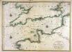
Carte de la Manche
1 Karte : Kupferdruck ; 56 x 79 cm Jaillot; Sanson chez Hubert Jaillot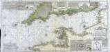
Carte de la Manche ou du Canal qui sépare les côtes de France d'avec celles d'Angleterre
1 Karte auf 2 Blättern : Kupferdruck ; 50 x 107 cm Beaurain; Martinet; Vallet chez le chevalier de Beaurain rue Git le cœur la 1.re porte à droite par le quay des Augustins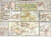
Tableau hidrographique qui contient le détail maritime des principaux ports qui se trouvent rèprèsentés dans la carte de la Manche
13 Karten auf einem Blatt : Kupferdruck ; Bildgrösse 47 x 70 cm Beaurain chez l'auteur rue Git-le Cœur la I.ere porte cochere à droite par le quai des Augustins
France Flle. N.O.
1 : 1000000 Vivien St Martin, L.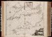
Pascaert van 't Canaal tusschen Engeland en Vranckryck
1 : 1150000 Annotatie: Oorspr. verschenen in: Zee atlas. - 't Amsterdam : by Jacobus Robyn, 1683; Origineel is Blad 25 in atlas factice [Amsterdam : gedruckt bij J. Robijn]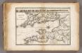
La Manche.
1 : 2100000 Vincent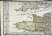
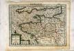
Le royaume de la France occidentale dit autrement Neustrie
1 Karte : Kupferdruck ; 39 x 49 cm, Bildgrösse 41 x 56 cm Duval chez l'auteur en l'isle du Palais sur le quay de l'Orloge
Carte De La Manche. [Karte], in: Atlas nouveau, contenant toutes les parties du monde [...], Bd. 1, S. 53.
1 Karte aus Atlas Sanson, Nicolas Jaillot, Alexis Hubert und Mortier, Pieter
Carte de la France, 1
2 Blätter : mehrfarbig ; 72 x 81 cm de Belleyme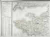
Carte de la France, 1
1 Blatt : 61 x 83 cm de Belleyme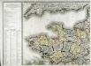
Carte de la France, 1
1 Blatt : 61 x 82 cm de Belleyme
France

Frankreich NW.
1 : 1700000 Handtke, Friedrich H.
Frankreich In 4 Blattern, Blatt 1.
1 : 1500000 Vogel, C.
Der Kanal
1 : 400000 Lamanšský průliv Reichs-Marine-Amt
[Frankreich, Blatt 1]
Adolf Stieler's Handatlas über alle Theile der Erde und über das Weltgebäude Stieler, Adolf Justus Perthes
[Frankreich in 4 Blättern, Blatt 1]
Handatlas über alle Theile der Erde und über das Weltgebäude Stieler, Adolf Justus Perthes
Postkarte von Frankreichs norwestlichen Departements oder der Normandie und Bretagne
Bretaň (Francie) Müller, Franz im von Reillyschen Landkarten und Kunstwerke Verschleiss Komptoir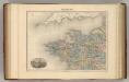
France N.O.
1 : 1615000 Migeon, J.
Carte de la République française, 1
1 Blatt : 42 x 51 cm P.G. Chanlaire