Maps of Outer Hebrides

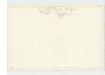
Insvlæ qvædam minores ex Æbudis quæ Mvlam et Skiam insulas interjacent
1 Karte : Kupferdruck ; 37 x 51 cm Blaeu; Pont Joan Blaeu
INSVLÆ QVÆDAM MINORES | ex Æbudis quæ MVLAM et SKIAM | insulas interjacent. | SOME OF THE SMALLER WESTERNE YLES, lying betweene the Yles of MVLE and SKYE.
Timoth: Pont auctor. [Amsterdam : Joan Blaeu]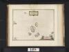
Insulae quaedam minores ex Aebudis quae Mulam et Skiam insulas interjacent. Some of the Smaller Westerne Yles, lying betweene the yles of Mule and Skye / Timotheo Pont auctor.
Pont, Timothy, 1560?-1614? Blaeu, Joan, 1596-1673
Rum - OS One-Inch map
1 : 63360 Topographic maps Ordnance Survey Ordnance Survey
Gighay - OS One-Inch map
1 : 63360 Topographic maps Ordnance Survey Ordnance Survey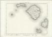
Rum - OS One-Inch map
1 : 63360 Topographic maps Ordnance Survey Ordnance Survey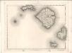
Rum - OS One-Inch map
1 : 63360 Topographic maps Ordnance Survey Ordnance Survey
Rhum and Part of Skye - OS One-Inch Map
1 : 63360 Topographic maps Ordnance Survey Ordnance Survey
The Cuillins, Rhum & Canna (34) - OS One-Inch map
1 : 63360 Topographic maps Ordnance Survey Ordnance Survey
The Cuillins, Rhum & Canna (34) - OS One-Inch map
1 : 63360 Topographic maps Ordnance Survey Ordnance Survey
Island of Eigg.
Leslie, Thomas, fl. 1824
Argyllshire (Islands of Canna & Sanday), Sheet LIX - OS 6 Inch map
1 : 10560 Topographic maps Ordnance Survey Ordnance Survey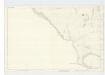
Argyllshire (Island of Rum), Sheet LXVI - OS 6 Inch map
1 : 10560 Topographic maps Ordnance Survey Ordnance Survey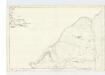
Argyllshire (Islands of Rum, Sanday &c), Sheet LX - OS 6 Inch map
1 : 10560 Topographic maps Ordnance Survey Ordnance Survey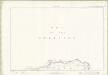
Inverness-shire - Isle of Skye Sheet LIII & LIV - OS 6 Inch map
1 : 10560 Topographic maps Ordnance Survey Ordnance Survey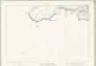
Inverness-shire - Isle of Skye Sheet LIX - OS 6 Inch map
1 : 10560 Topographic maps Ordnance Survey Ordnance Survey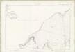
Inverness-shire - Isle of Skye Sheet LX - OS 6 Inch map
1 : 10560 Topographic maps Ordnance Survey Ordnance Survey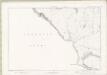
Inverness-shire - Isle of Skye Sheet LXVI - OS 6 Inch map
1 : 10560 Topographic maps Ordnance Survey Ordnance Survey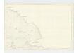
Argyllshire (Island of Rum), Sheet LXI - OS 6 Inch map
1 : 10560 Topographic maps Ordnance Survey Ordnance Survey
Inverness-shire - Isle of Skye Sheet LXIX - OS 6 Inch map
1 : 10560 Topographic maps Ordnance Survey Ordnance Survey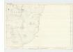
Argyllshire (Island of Rum), Sheet LXVII - OS 6 Inch map
1 : 10560 Topographic maps Ordnance Survey Ordnance Survey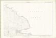
Inverness-shire - Isle of Skye Sheet LXI - OS 6 Inch map
1 : 10560 Topographic maps Ordnance Survey Ordnance Survey
Inverness-shire (Isle of Skye), Sheet LVI - OS 6 Inch map
1 : 10560 Topographic maps Ordnance Survey Ordnance Survey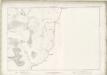
Inverness-shire - Isle of Skye Sheet LXVII - OS 6 Inch map
1 : 10560 Topographic maps Ordnance Survey Ordnance Survey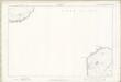
Inverness-shire - Isle of Skye Sheet LXX - OS 6 Inch map
1 : 10560 Topographic maps Ordnance Survey Ordnance Survey
Inverness-shire - Isle of Skye Sheet LVI - OS 6 Inch map
1 : 10560 Topographic maps Ordnance Survey Ordnance Survey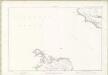
Inverness-shire - Isle of Skye Sheet LXXII - OS 6 Inch map
1 : 10560 Topographic maps Ordnance Survey Ordnance Survey
Inverness-shire (Isle of Skye), Sheet LXII - OS 6 Inch map
1 : 10560 Topographic maps Ordnance Survey Ordnance Survey
Inverness-shire - Isle of Skye Sheet LXII - OS 6 Inch map
1 : 10560 Topographic maps Ordnance Survey Ordnance Survey