Maps of Outer Hebrides

A general map of Scotland and islands thereto belonging, 1
2 Blätter : 90 x 76 cm s.n.
Tabula Leogi et Haraiae, ac Skiae vel Skianae Insularum. [Karte], in: Novus atlas absolutissimus, Bd. 8, S. 169.
1 Karte aus Atlas Janssonius Offizin
A new chart of the West coast of Scotland from the Mull of Galloway to Dunan Point in Sky.
Huddart, Joseph, 1740/1-1816 Laurie, Robert Whittle, James
Carte particuliere de la cote occidentale d'Escosse, depuis le Cape Wrath jusqu'a la Pointe d'Ardnamurchan.
Depot Generale de la Marine, Paris
A new chart of the West coast of Scotland from the point of Ardnamurchan to Cape Wrath.
Huddart, Joseph, 1740/1-1816 Laurie, Robert Whittle, James
Western Isles.
Thomson, John, 1777- ca. 1840 Johnson, William, fl. 1806-1840
Western Isles.
Thomson, John, 1777- ca. 1840 Johnson, William, fl. 1806-1840
Western Isles.
Thomson, John, 1777- ca. 1840 Johnson, William, fl. 1806-1840
Scotland[Motoring Map of]
London : "Geographia
The Shires of Ross, and Cromartie / by Her. Moll.
Moll, Herman, d. 1732
Tabula Leogi et Haraiæ, ac Skiæ vel Skianæ insularum
1 Karte : Kupferdruck ; 43 x 51 cm Valck; Schenk ex officina Gerardi Valk et Petri Schenk
Pascaert vande westkust van Schotlant, als mede een gedeelte van de Lewys Eylanden, van S. Patricius tot Nary, Nog t'I. Roda ofte Barre en t'I. S. Kilda met al Syn diepten en droochten, dus ver naeuke
Keulen, Johannes van, 1654-1715
Scotland / J. Ainslie, 1
1 Blatt : 64 x 58 cm Ainslie, Faden
A Map of the North West part of the Western Islands / by H. Moll.
Moll, Herman, d. 1732
Extima Scotiæ septentrionalis ora
1 Karte : Kupferdruck ; 40 x 50 cm Blaeu; Gordon Joan Blaeu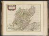
Extima Scotiae septentrionalis ora, ubi Provinciae sunt Rossia, Sutherlandia, Cathenesia, Strath-Naverniae, cum vicinis regiunculis quae eis subsunt, etiamque Moravia / R. Gordonius à Strath-loch coll
Gordon, Robert, 1580-1661 Blaeu, Joan, 1596-1673
Lochabria, omnesq[ue] insulæ versus occidentem sitæ, ut Visto, Mulla, aliæque
1 Karte : Kupferdruck ; 42 x 51 cm Valck; Schenk sumptibus Gerardi Valk et Petri Schenk
Ardnamurchan to Summer Isles, including the Inner Channel and part of the Minch.
Great Britain. Hydrographic Office
Scotland / J. Ainslie, 2
1 Blatt : 68 x 58 cm Ainslie, Faden
LEOGVS et HARAIA, | insulæ ex Æbudarum numero, | quæ, quamquam isthmo cohæreant, | pro diversis habentur. | LEWIS and HARRAY | of the numbre of the Westerne Yles, which two although | they ioyne be a necke of land ar accounted dyvers Ylands.
[Amsterdam : Joan Blaeu]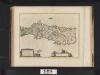
Leogus et Haraia insulae ex Aebudarum numero, quae quamquam isthmo cohaereant, pro diversis habentur. Lewis and Harray of the numbre of the Western Yles, which two although they ioyne be a necke of la
Blaeu, Joan, 1596-1673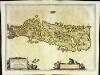
Leogvs et Haraia
1 Karte : Kupferdruck ; 38 x 51 cm Blaeu Joan Blaeu
The North Minch
Great Britain. Hydrographic Office
Harris & The Lewis, Sheet 23 - Bartholomew's "Half Inch to the Mile Maps" of Scotland
1 : 126720 Topographic maps John Bartholomew & Son, Ltd John Bartholomew & Son, Ltd
Outer Hebrides, Sheet 23 - Bartholomew's "Half Inch to the Mile Maps" of Scotland
1 : 126720 Topographic maps Bartholomew, John George John Bartholomew & Co
Island of Skye
1 : 126720 Ordnance Survey Office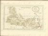

Uist & Barra, Sheet 18 - Bartholomew's "Half Inch to the Mile Maps" of Scotland
1 : 126720 Topographic maps John Bartholomew & Son, Ltd John Bartholomew & Son, Ltd
North & South Uist, Sheet 18 - Bartholomew's "Half Inch to the Mile Maps" of Scotland
1 : 126720 Topographic maps Bartholomew, John George John Bartholomew & Co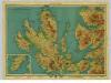
Isle of Skye, Sheet 19 - Bartholomew's "Half Inch to the Mile Maps" of Scotland
1 : 126720 Topographic maps John Bartholomew & Son, Ltd John Bartholomew & Son, Ltd


