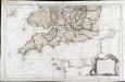
Maps of South West England
Partie meridionale de l'Angleterre
1 Karte : Kupferdruck ; 53 x 84 cm s.n.
Canalis inter Angliæ et Galliæ littora
1 Karte : Kupferdruck ; 48 x 55 cm Renard gedruckt by L. Renard
Parte meridionale dell' Inghilterra, e del principato di Galles
1 Karte : Kupferdruck ; 29 x 40 cm Zatta; Zuliani; Pitteri presso Antonio Zatta
Carte reduite de la Manche
1 Karte : Kupferdruck ; 54 x 83 cm Bellin s.n.
La Manche
1 Karte : Kupferdruck ; 50 x 61 cm Jefferys; Le Rouge chez Le Rouge géographe du roi rue des g.ds Augustins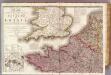
France 1.
1 : 1170000 Herisson, Eustache, b. 1759
A Chart of the English Channel with the adjacent coasts of England and France.
from Atlantic Ocean
Pas caart van de canaal tusschen Engeland en Vrancrijck
1 Karte : Kupferdruck ; 43 x 53 cm Doncker by Hendrick Doncker boeckverkoper en graedbooghmaecker inde Nieuwbrugsteegh in 't Stuurmans gereedschap
La Manche
1 Karte : Kupferdruck ; 50 x 61 cm Jefferys; Le Rouge chez Le Rouge géographe du roi rue des g.ds Augustins
Pascaert van 't Canaal tusschen Engeland en Vranckryck
1 : 1150000 Annotatie: Oorspr. verschenen in: Zee atlas. - 't Amsterdam : by Jacobus Robyn, 1683; Origineel is Blad 25 in atlas factice [Amsterdam : gedruckt bij J. Robijn]
Carte de la Manche
1 Karte : Kupferdruck ; 50 x 66 cm Lattré chéz Lattré graveur ordinaire du roi de M. le duc d'Orléans et de la ville rue St. Jacques la porte cochère en face de la rue de la Parcheminerie
England and Wales (Southern section)
1 : 675000 Rocque, John
Carte De La Manche. [Karte], in: Atlas nouveau, contenant toutes les parties du monde [...], Bd. 1, S. 53.
1 Karte aus Atlas Sanson, Nicolas Jaillot, Alexis Hubert und Mortier, Pieter
[130][133] Pascaert van 't Canaal tusschen Engeland en Vranckryck, uit: Atlas sive Descriptio terrarum orbis
Annotatie: Gedigitaliseerde versie. Amsterdam. Heiloo : Picturae (vervaardiger), 2015. tiff-bestand. Gedigitaliseerd: 07-01-2015; Origineel: Universiteitsbibliotheek Vrije Universiteit (XL.05127.-) ; Netherlands; Titelpagina ontbreekt Wit, Frederik de Amsterdam : Frederick de Wit
Manica, gallis la Manche, et belgis het Canaal, pars oceani inter Angliam et Gallicam
1 Karte : Kupferdruck ; 46 x 55 cm Visscher; Gouwen Nicolaes Visscher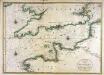
Carte de la Manche
1 Karte : Kupferdruck ; 56 x 79 cm Jaillot; Sanson chez Hubert Jaillot
England and Wales (southern sheet).
1 : 887000 Johnston, W. & A.K.
Galliæ antiquæ descriptio geographica, 1
1 Blatt : 44 x 57 cm s.n.
England and Wales.
1 : 1420000 Hammond, C.S.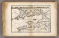
La Manche.
1 : 2100000 Vincent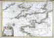
Carte de la Manche
1 Karte : Kupferdruck ; 47 x 68 cm Denis; Basset; Basset chés Basset rue St. Jacques au coin de celle des Mathurins
(England, Wales, south)
1 : 575000 Kitchin, Thomas; Phillips, J.; Robert Laurie & James Whittle
La Manche, ou le Canal, entre la France et l'Angleterre
1 Karte : Kupferdruck ; 49 x 59 cm Jaillot; Goere H. Jaillot
A chart of the British Channel.
1 : 1780000 Jefferys, Thomas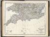
England, Wales S.
1 : 887000 Johnston, Alexander Keith, 1804-1871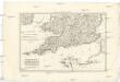
Royaume d'Angleterre
1 : 1950000 Anglie jižní Bonne, Rigobert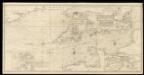
An exact trigonometrical survey of the British Channel, including the mouth of the Thames and Part of the German sea with the coast of Irland from Carnsore point to the Shannon Mouth
Laurie & Whittle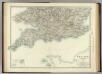
England and Wales (southern sheet).
1 : 887000 Johnston, Alexander Keith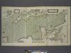
A new and correct draught of the CHANNELL between ENGLAND and FRANCE
from The sea-atlas : containing an hydrographical description of most of the sea-coasts of the known parts of the world.


