Maps of Zuid-Holland

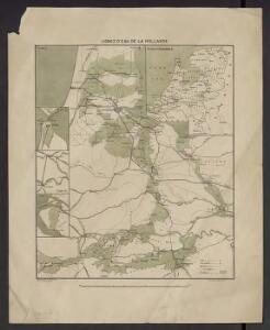
Lignes d'eau de la Hollande
1 : 263000 [Lieu de publication inconnu] : [éditeur inconnu]
Hollandia Comitatvs
1 : 530000 Mollova mapová sbírka Merian, Caspar Merian, Caspar
Comitatus Hollandiae Tabula Pluribus Locis
1 : 500000 Mollova mapová sbírka Wit, Frederik de Covens, Johannes I
Figurative caert vande situatie van Gelderland, Holland, Utrecht en Overijssel, ten reguarde van zee en rivieren, Ao. 1744.
1 : 100000 [S.l.] : [s.n.]
Figurative kaart vande situatie van Gelderland, Holland, Uijtrecht en Overyzel, ten regarde van zee, en rivieren.
1 : 100000 [S.l.] : [s.n.]
Figurative kaart vande situatie van Gelderland, Holland, Uijtrecht en Overyzel, ten regarde van zee, en rivieren.
1 : 100000 [S.l.] : [s.n.]
Hollandia Meridional.
1 : 1300000 [Jodocus Hondius jr. engraver] [Amsterdam] : [Jodocus Hondius jr.]
Amsterdam 55, uit: Special-Karte von Mittel-Europa / nach amtlichen Quellen bearbeitet von W. Liebenow
1 : 300000 titelvariant: W. Liebenow's Mittel-Europa; Annotatie: Titel boven de bladen: W. Liebenow's Mittel-Europa Johannes Wilhelm Liebenow 1822-1897 Frankfurt a. M. : Ludwig Ravenstein
[Map of the southern part of Holland]
1 : 95000 [Jacob Keizer] Te Amsterdam : by Reinier en Josua Ottens
Utrecht, uit: Sterfte-atlas van Nederland over 1860-1874 / [uitgave van de Nederlandsche Maatschappij tot Bevordering der Geneeskunst]
titelvariant: Sterfte-atlas van Nederland; Annotatie: Alleen kaartbijlage aanwezig Pieter Harmen Witkamp 1816-1892; Nederlandsche Maatschappij tot Bevordering der Geneeskunst Amsterdam : van Rossen
Ultraiectum Dominium
1 : 415000 Petrus Kærius cælavit. [Amsterdam] : [Jan Evertsz. Cloppenburgh]
Ultraiectini Dominii Tabula [Karte], in: Novus atlas absolutissimus, Bd. 3, S. 203.
1 Karte aus Atlas Janssonius Offizin
Ultraiectini Dominii tabula multo aliis auctior et correctior
1 : 100000 per F. de Wit. Tot Amsterdam : by Frederick de Wit ...
Amsterdam 55, uit: [W. Liebenow's Special-Karte von Mittel-Europa]
1 : 300000 titelvariant: W. Liebenow's Mittel-Europa; Annotatie: Titel boven de bladen: W. Liebenow's Mittel-Europa Johannes Wilhelm Liebenow 1822-1897 Hannover : Hermann Oppermann
[99][100] Ultraiectini Dominii tabula, uit: Atlas sive Descriptio terrarum orbis
Annotatie: Gedigitaliseerde versie. Amsterdam. Heiloo : Picturae (vervaardiger), 2015. tiff-bestand. Gedigitaliseerd: 07-01-2015; Origineel: Universiteitsbibliotheek Vrije Universiteit (XL.05127.-) ; Netherlands; Titelpagina ontbreekt Wit, Frederik de Amsterdam : Frederick de Wit
Ultraiectini Dominii tabula
1 : 120000 multo aliis auctior et correctior per F. de Wit. T'Amsterdam : by J. Covens en C. Mortier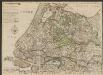
Nieuwe kaart van Holland, Utrecht, de Vyf Heeren Landen en een gedeelte van Gelderland. naar de nieuwste waarnemingen geteekent
1 : 175000 [C. Cóvens, delin.] [C. van Baarsel, sculpt. 1792] Te Amsterdam : by Iohannes Covens en Zoon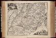
Ultraiectini Dominii tabula / multo aliis auctior et correctior per Nic. Visscher ; R. de Hooghe fecit
1 : 180000 Annotatie: Origineel is Blad 55 in atlas factice; Annotatie geografische gegevens: Zuidwest boven; Met 3 schaalstokken Nicolaes Jansz Visscher sr 1618-1679; Romeyn de Hooghe 1645-1708 [Amsterdam : Nicolaes Visscher]
[Recto], uit: Utrecht / [door W.J. Geerling]
1 : 200000 titelvariant: Gemeentekaart van Utrecht; Annotatie: Titel op omslag: Gemeentekaart van Utrecht; Verso: plaatsnamenregister; Annotatie geografische gegevens: Rechtsonder: 'Verklaring der teekens'. 'De Gemeenten zijn in verschillende kleuren aangegeven. De naam der gemeente is onderstreept' ['s-Gravenhage : J. Smulders]
Kaartje van de provincie van Zuid Holland na de laaste verbetering
1 : 550000 [Jacob Keizer] [Amsterdam] : [Reinier en Josua Ottens]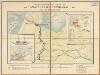
Amsterdam-Rheinkanal : frei von Kanalabgaben / [getekend door] J.H. Schmüll
1 : 250000 Annotatie: Boven de kaart: Handelskammer in Amsterdam; Met informatie over de Amsterdamse haven, het Noordzee-kanaal, het Amsterdam-Rijnkanaal en de scheepvaart over deze kanalen; Annotatie geografische gegevens: Inzetkrt.: 1. Doorsnede met laagste waterstand. - 1:250 ; 2. Amsterdam. - 1:25.000 ; 3. Holland-Deutschland, Verkehr auf dem Rhein, 1892. - 1:4.000.000 J.H. Schmüll [S.l. : s.n.] / (Amsterdam : Tresling & Co)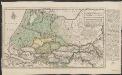
Kaart van den loop der rivieren de Rhijn, de Maas, de Waal, de Merwe, en de Lek, door de provincien van Gelderland, Holland en Utrecht
1 : 350000 C. Velsen delin. Is. Tirion excud. Amsterdam : Isaak Tirion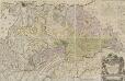
Nieuwe kaart van den Lande van Utrecht
1 : 44000 volgens ordre van d'Ed. Mog. Heeren Staten van welgemelden lande doen meten, en in kaart brengen, door Bernard du Roy G. Hoet, del. ornam. ; T. Doesburgh, sculps. Tot Amsterdam : door Johannes Covens en Cornelis Mortier

Kaart van de provincie Utrecht verdeeld in arrondissementen en regterlijke kantons, ingevolge besluit van Z.M. den Koning der Nederlanden = Province d’Utrecht, divisée en arrondissemens et cantons judiciaires par arrêté de S.M. le Roi des Pays-Bas
dressée gravée et publiée par F. Desterbecq, vu par le Cadastre. La Haye : Établissement Géographique de F. Desterbecq
Ultraiectini Dominii tabula
1 : 120000 multo aliis auctior et correctior per I. Danckerts. Tot Amsterdam : by Justus Danckers
Utrecht, divisé en arrondissemens et cantons de justice de paix
1 : 180000 dressé et gravé par C. van Baarsel et fils. À La Haye : chez F.J. Weygand
Kaart van den loop der rivieren de Rhijn, de Maas, de Waal, de Merwe, en de Lek, door de provincien van Gelderland, Holland en Utrecht
1 : 350000 C. Velsen delin. Is. Tirion excud. Amsterdam : Isaak Tirion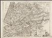
Contado d'Ollanda, parte meridionale
1 : 200000 [Vincenzo Coronelli] [Venezia] : [Vincenzo Coronelli]