Maps of Zuid-Holland

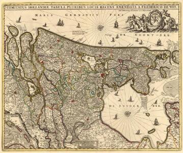
Comitatus Hollandiae Tabula Pluribus Locis
1 : 500000 Mollova mapová sbírka Wit, Frederik de Covens, Johannes I
Hollandia
1 : 950000 [Jodocus Hondius sr. engraver] [Amsterdam etc.] : [Jodocus Hondius sr. etc.]
Comitatus Hollandia
1 : 1200000 [Abraham Goos engraver] [Amsterdam etc.] : [Abraham Goos etc.]
Hollandia
1 : 950000 [Jodocus Hondius sr. engraver] [Amsterdam etc.] : [Jodocus Hondius sr. etc.]
Charte von Holland
1 Karte : Kupferdruck ; 55 x 43 cm Güssefeld by den Hom. Erben
Hollandia Comitatus
1 : 990000 [Pieter van den Keere engraver] [Amsterdam] : Johannes Janssonius]
Hollandia
1 : 1500000 [Jodocus Hondius jr. engraver] [Amsterdam] : [Jodocus Hondius jr.]
Tabula Comitatus Hollandiæ cum ipsius consinijs Dominii nimirum Ultraiectini nec non Geldriæ et Frisiæ geographice tradita curis
1 : 300000 [Homann Heirs] Norib. : Homannianorum Heredum
Le Comte de Hollande
1 : 750000 auctore Baltha: Florentius de Berkenrode. [Amsterdam] : [Jacob Aertsz. Colom]
Hollandiae cattorum regionis typus
1 : 550000 [Lodovico Guicciardini] [Antwerpen] : [Christoffel Plantijn]
Contado d'Ollanda, parte settentrionale
1 : 200000 [Vincenzo Coronelli] [Venezia] : [Vincenzo Coronelli]
Caerte vanden lande ende graefschappe van Hollandt, midtsgaders het landt van Utrecht, de deelen ende houcken van andere landê annex Holl[an]t gelegê, ende tselve landt naest beleyt hebben, perfect gemaect nade jegenwoirdige situatie eñ gelegentheyt
1 : 480000 [Jan Pietersz. Saenredam engraver] [Amsterdam] : [Cornelis Claesz.]
La Hollande suivant les nouvelles observations de messrs. de l'Academie Royale des Sciences, etc. augmentées de nouveau
1 : 900000 [Pieter van der Aa] A Leide : chez Pierre van der Aa
Le Comte de Hollande
1 : 750000 auctore Baltha: Florentius de Berkenrode. [Amsterdam] : La Feuille exc.
Comitatus Hollandiae tabula
1 : 300000 pluribus locis recens emendata a Francisco Caroli J. Bormeester. eccu. Amstel' : Petrum Schenk exc.
Comitatus Hollandiae novissima descriptio
1 : 760000 designatore Balth. Flor. a Berckenr. Amstelodami : sumptibus Henrici Hondii.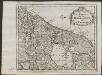
Les provinces de la Hollande et d'Utrecht
1 : 800000 [Anthoni de Winter] [Amsterdam] : [François Halma]
Comitatus Hollandiae tabula pluribus locis
1 : 308000 Nizozemsko Visscher, Nicolaes Jansz. Schenk, Pieter apud Petrum Schenk Junior
Comitatus Hollandiae tabula pluribus locis
1 : 308000 Nizozemsko Wit, Frederick de by Frederick de Wit
Le Comté de Hollande
1 : 240000 dressé sur les memoires les plus nouveaux par le Sr. Sanson, geographe ordinaire du roy presenté à ... le Dauphin ... par ... Alexis Hubert Jaillot. A Amsterdam : chez I. Cóvens et C. Mortier

HOLLANDIA | COMITATVS
Apud Guiljelmum Blaeu
Comitatus Hollandiae tabula
1 : 300000 pluribus locis recens emendata a Frederico de Wit. [Amsterdam] : ex officina I. C
Hollandiae Comitatus
1 : 300000 Mollova mapová sbírka Visscher, Nicolaes Schenk, Peter II
Charte von Holland
1 : 300000 nach astronomischen Beobachtungen, den Messungen des Schnellius &.c.c. und den vorzüglichsten Specialcharten neu entworfen von F.L. Güssefeld. Nürnberg : bey den Hom[ännischen Erben]

Belgio confederato altrimenti detto l'Olanda, delineato
1 : 1200000 delineato, e descritto dal P. Coronelli. [Napoli] : [Vincenzo Coronelli]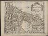
De provintien van Hollandt en Utrecht
1 : 800000 [Anthoni de Winter] [Amsterdam] : [François Halma]
Kaart van't Graafschap Holland Naauwkeurig afgedeelt in zyne Heemraadschappen, Baljuwschappen en Waarden nevens verscheide andere minder afdeelingen en onderhorige landen als mede van de Heerlykheit Utrecht en het grootste gedeelte van Gelderlandt
1 : 300000 Mollova mapová sbírka Specht, Caspar Ottens, Josua