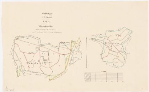
Maps of Winterthur
Seen: Gemeindewaldung: Nübrechten, Etzberg; Grundrisse
1 : 5000 Ergänzter Plan auf der Basis der in den Jahren 1839 und 1847 von Jakob Hertenstein, Forstmeister des 2. Kreises des Kantons Zürich, von Kyburg, angefertigten Aufnahme. Zeichnung: Hartmann, Karl, Forstadjunkt im Zürcher Oberforstamt, von Aarau, in Unterstrass; Volkart, Forstpraktikant
Seen: Gemeindewaldung: Nübrechten (Neubrechten); Grundriss
1 : 2400 Mit Verzeichnis der Flächeninhalte. Mit handschriftlichen Eintragungen und Einzeichnungen, welche im Rahmen der Revision im Jahr 1891 und später mit Tinte angebracht wurden. Auftraggebung: Forstkommission Aufnahme und Zeichnung: Hertenstein, Jakob, Forstmeister des 2. Kreises des Kantons Zürich, von Kyburg
Seen: Gemeindewaldung: Nübrechten (Neubrechten); Grundriss
1 : 2400 Mit handschriftlichen Eintragungen und Einzeichnungen, welche nach der eigentlichen Zeichnung des Plans, d. h. nach 1839, mit Tinte und Grafitstift angebracht wurden. Auftraggebung: Forstkommission Aufnahme und Zeichnung: Hertenstein, Jakob, Forstmeister des 2. Kreises des Kantons Zürich, von Kyburg
Seen: Wasserleitungen in Neubrechten nördlich Sennhof; Situationsplan und Längsprofil (Blatt IV)
1 : 1000 Mit Angabe der Namen von Grundeigentümern.
Kyburg, Seen: Töss unterhalb der Brücke bei Sennhof; Situationsplan (Töss-Gebiet Nr. 2, Blatt 46)
1 : 1000 Kilometer 25.045 bis 25.675. Messtischblatt. Mit Angabe der Namen der Grundeigentümer. Ohne Datumsangabe. Peter, R.
Seen: Pfrundgüter Pfarrgarten, Blumengarten und Wiese; Grundriss (Nr. 1)
1 : 1200 Frey, Johann Jakob, von Knonau
Kyburg, Seen: Von Sennhof bis unterhalb der Einmündung des Beerentalbachs, Tösskorrektion; Situationsplan (Töss-Gebiet Nr. 20, Blatt 5)
1 : 1000 Kilometer 24.990 bis 25.620. Messtischblatt. Mit Angabe der Namen der Grundeigentümer. Ohne Datumsangabe.
Winterthur, Oberwinterthur, Wülflingen, Turbenthal: Stadtwaldung Winterthur: Südöstlicher Teil: Im Loo, Hof Eschenberg, Im Moos, Jucherten (Jucharten), Hinterwald (Wald Ebne), Steigtobel, Häsenthal, Chalberweid, Falkentobel, Häsental; Grundriss (Tab. III)
1 : 3000 Erstellt auf der Basis der in den Jahren 1835 und 1836 von Jakob Melchior Ziegler (1801-1883), Kartograf, durchgeführten Planaufnahme. Zeichnung: Hertenstein, Wilhelm Friedrich (1825-1888), Forstadjunkt im Zürcher Oberforstamt, von Kyburg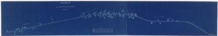
Seen: Wasserleitung von Mattenbach über Unterdorf und Oberdorf bis vor Sennhof; Situationsplan
1 : 1000 Mit Originalvermerk: Verfügt: 21. April 1885.
Winterthur: Gemeinde; Kanalisation: Blatt 16: Seen mit Gern, Neudorf, Waldegg, Weierwiesen, Paradis (Paradies), Hof Eschenberg, Gatter, Boll und Chatzensteig (Katzensteig); Übersichtsplan
Auf Ausgangsplan angebrachte Eintragungen in roter Farbe. Ohne Datumsangabe.
Seen: Zehntenbezirk Mulchlingen, zehntenpflichtig dem Amt Winterthur; Grundriss
1 : 2615 Mit Verzeichnis der Flächeninhalte und der Beschaffenheit der einzelnen Güter. Schäppi, Jakob, Kartograf, von Oberrieden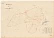
Winterthur, Lindau: Gemeindewaldungen: Winterthur: Steintobel, Birch, Hinterwald, Waldebni, Jucherten (Jucharten); Grundriss
1 : 2000 Mit Verzeichnis der Flächeninhalte. Ausgangsplan: Grundbuchplan 105 der Gemeinde Winterthur.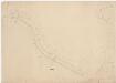
Kyburg, Seen: Von oberhalb bis unterhalb Sennhof, Tösskorrektion; Situationsplan (Töss-Gebiet Nr. 40 l)
1 : 1000 Kilometer 24.511 bis 25.971. Mit Originalvermerk: Nach dem Hochwasser v. 11-13 Juni 1876.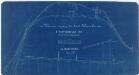
Seen, Zell: Wasserleitungen von im Ried über Sennhof bis Ankenberg; Situationsplan und Längsprofil (Blatt IV)
1 : 1000 Mit Angabe der Namen von Grundeigentümern. Ergänzungen und Projektverfassung: Weinmann, C., Ingenieur, in Winterthur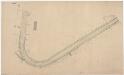
Kyburg, Seen: Von Sennhof bis oberhalb Kyburg, Tösskorrektion; Situationsplan (Töss-Gebiet Nr. 42 c)
1 : 1000 Kilometer 25.050 bis 26.230. Mit Angabe der Namen der Grundeigentümer.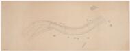
Kyburg, Seen: Töss bei Sennhof, Syphon; Situationsplan (Töss-Gebiet Nr. 53)
1 : 1000 Kilometer 24.500 bis 25.100. Ohne Datumsangabe.
Seen: Strassenkorrektion durch das Dorf; Situationsplan
Mit Angabe der Namen von Gebäudeeigentümern. Ohne Datumsangabe.
Winterthur: Definition der Siedlungen für die eidgenössische Volkszählung am 01.12.1970; Siedlungskarten: Teilkarte VIII
1 : 5000 Auf Ausgangskarte angebrachte farbige Einzeichnungen und Eintragungen. Mit Legende. Ohne Erstellungsdatumsangabe. Ausgangskarte: Übersichtsplan (Schweizerische Grundbuchvermessung) der Gemeinde Winterthur. Ausgangskarte: Vermessungsbüro der Stadt Winterthur
Seen: Zehntenbezirke Unterseen und Oberseen, zehntenpflichtig dem Amt Winterthur, dem Prokurei-Amt Winterthur und dem Spitalamt Winterthur, samt zehntenfreien Gütern; Grundriss
1 : 2630 Mit Verzeichnissen der Beschaffenheit und der Flächeninhalte der einzelnen Güter. Schäppi, Jakob, Kartograf, von Oberrieden
Vorlagen für die Topographische Karte des Kantons Zürich (Wild-Karte): Pausen mit Gewässern, Eisenbahn, Strassen: Originalblatt XV: Sektion Turbenthal
1 : 25000
Plan der Stadtwaldung Eschenberg
1 : 10000 1 Karte fortgeführt durch das Städt. Kataster Bureau
Kyburg: Dem Amt Winterthur gehörende Schlosswaldung (zehn Waldbezirke); Grundrisse (XV. Planche)
Mit Verzeichnis der Namen und Flächeninhalte der zehn Waldbezirke. Aufnahme: Hotz, Heinrich (1768-1813), Forstmeister des Kantons Zürich, von Oberrieden Zeichnung: Hirzel, Hans Caspar (1756-1841), Ober- bzw. Kantonsforstinspektor, von Zürich
Winterthur, Oberwinterthur, Wülflingen, Turbenthal: Stadtwaldung Winterthur: Winterthur: Eschenberg; Übersichtsplan
1 : 12000 Mit Legende der verwendeten Zeichen. Mit Verzeichnis der Flächeninhalte und der Art des Baumbestandes. Aufnahme: Ziegler, Jakob Melchior (1801-1883), Kartograf Stich und Druck: Joh. Wurster und Comp., in Winterthur
Elsau, Oberwinterthur, Seen: Manöverfeld östlich von Winterthur mit Lagerplätzen; Grundriss
1 : 10000 Mit Erläuterungen zu den für tauglich befundenen Lagerplätzen entlang des Mattenbachs und der Eulach sowie zum "Manövrierfeld". Biedermann, Leutnant
Plan des Waldes Eschenberg
1 : 12000 1 Karte aufgenommen u. gez. v. J.M. Ziegler 1835 ; reduzirt u. gest. in der topogr. Anstalt v. J. Wurster u. Comp.
Winterthur, Oberwinterthur, Veltheim, Wülflingen: Stadtgemeinde und umliegende Gemeinden; Übersichtsplan: Blatt 4
1 : 5000 Kartographia Winterthur AG, in Winterthur
Winterthur, Oberwinterthur, Wülflingen, Turbenthal: Stadtwaldung Winterthur: Winterthur: Eschenberg; Übersichtsplan
1 : 9000 Mit Legende der verwendeten Zeichen. Mit Verzeichnis der Flächeninhalte und der Art des Baumbestandes. Aufnahme und Zeichnung: Ziegler, Jakob Melchior (1801-1883), Kartograf Verkleinerung und Steingravur: Wurster, Johann Ulrich (1814-1880) Lithografie: Studer, C.
Winterthur, Oberwinterthur, Wülflingen, Turbenthal: Stadtwaldung Winterthur: Winterthur: Eschenberg; Übersichtsplan
1 : 9000 Mit Legende der verwendeten Zeichen und Farben. Mit Verzeichnis der Flächeninhalte und der Art des Baumbestandes. Aufnahme und Zeichnung: Ziegler, Jakob Melchior (1801-1883), Kartograf Verkleinerung und Steingravur: Wurster, Johann Ulrich (1814-1880) Lithografie: Studer, C.
Winterthur, Oberwinterthur, Wülflingen, Turbenthal: Stadtwaldung Winterthur: Winterthur: Eschenberg; Übersichtsplan
1 : 9000 Mit Legende der verwendeten Zeichen. Mit Verzeichnis der Flächeninhalte und der Art des Baumbestandes. Aufnahme und Zeichnung: Ziegler, Jakob Melchior (1801-1883), Kartograf Verkleinerung und Steingravur: Wurster, Johann Ulrich (1814-1880) Lithografie: Studer, C.