Maps of Winterthur

Winterthur, Oberwinterthur, Wülflingen, Turbenthal: Stadtwaldung Winterthur: Südöstlicher Teil: Im Loo, Hof Eschenberg, Im Moos, Jucherten (Jucharten), Hinterwald (Wald Ebne), Steigtobel, Häsenthal, Chalberweid, Falkentobel, Häsental; Grundriss (Tab. III)
1 : 3000 Erstellt auf der Basis der in den Jahren 1835 und 1836 von Jakob Melchior Ziegler (1801-1883), Kartograf, durchgeführten Planaufnahme. Zeichnung: Hertenstein, Wilhelm Friedrich (1825-1888), Forstadjunkt im Zürcher Oberforstamt, von Kyburg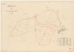
Winterthur, Lindau: Gemeindewaldungen: Winterthur: Steintobel, Birch, Hinterwald, Waldebni, Jucherten (Jucharten); Grundriss
1 : 2000 Mit Verzeichnis der Flächeninhalte. Ausgangsplan: Grundbuchplan 105 der Gemeinde Winterthur.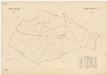
Winterthur, Lindau: Gemeindewaldungen: Winterthur: Gatter, Isler, Im Hau, Roossen (In den Rosen), Riet (Ried), Hof Eschenberg; Grundriss
1 : 2000 Mit Verzeichnis der Flächeninhalte. Ausgangsplan: Grundbuchplan 102 der Gemeinde Winterthur.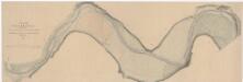
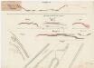
Kyburg, Winterthur: Töss von Linsental bis unterhalb der oberen Au; Situationsplan (Töss-Gebiet Nr. 21 a bzw. I. Blatt)
1 : 1000 Kilometer 25.760 bis 28.250. Aufnahme: Wimmersberger, Jakob (1815-1860), Ingenieur, von Wülflingen
Winterthur: Gemeinde; Kanalisation: Blatt 16: Seen mit Gern, Neudorf, Waldegg, Weierwiesen, Paradis (Paradies), Hof Eschenberg, Gatter, Boll und Chatzensteig (Katzensteig); Übersichtsplan
Auf Ausgangsplan angebrachte Eintragungen in roter Farbe. Ohne Datumsangabe.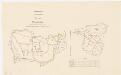
Seen: Gemeindewaldung: Nübrechten, Etzberg; Grundrisse
1 : 5000 Ergänzter Plan auf der Basis der in den Jahren 1839 und 1847 von Jakob Hertenstein, Forstmeister des 2. Kreises des Kantons Zürich, von Kyburg, angefertigten Aufnahme. Zeichnung: Hartmann, Karl, Forstadjunkt im Zürcher Oberforstamt, von Aarau, in Unterstrass; Volkart, Forstpraktikant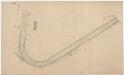
Kyburg, Seen: Von Sennhof bis oberhalb Kyburg, Tösskorrektion; Situationsplan (Töss-Gebiet Nr. 42 c)
1 : 1000 Kilometer 25.050 bis 26.230. Mit Angabe der Namen der Grundeigentümer.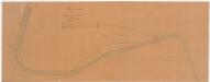
Kyburg, Seen, Winterthur: Von Sennhof bis oberhalb Kyburg, Tösskorrektion; Situationsplan (Töss-Gebiet Nr. 37)
1 : 1000 Mit Angabe der Namen der Grundeigentümer. Wepfer, J., Ingenieur
Kyburg, Winterthur: Von oberhalb bis unterhalb der gedeckten Brücke in Kyburg, Tösskorrektion; Situationsplan (Töss-Gebiet Nr. 7, Blatt 2)
1 : 2000 Kilometer 25.750 bis 27.240. Messtischblatt. Ohne Datumsangabe.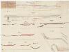
Kyburg, Seen: Töss unterhalb Sennhof, Hinterwassereinlauf und Strassenkorrektion; Situationsplan, Grundriss, Längsprofil, Längsschnitt und Profile (Töss-Gebiet Nr. 58)
1 : 1000 Kilometer 26.205 bis 26.750. Zweifel, H.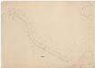
Kyburg, Seen: Von oberhalb bis unterhalb Sennhof, Tösskorrektion; Situationsplan (Töss-Gebiet Nr. 40 l)
1 : 1000 Kilometer 24.511 bis 25.971. Mit Originalvermerk: Nach dem Hochwasser v. 11-13 Juni 1876.
Kyburg, Seen: Töss unterhalb der Brücke bei Sennhof; Situationsplan (Töss-Gebiet Nr. 2, Blatt 47)
1 : 1000 Kilometer 25.675 bis 25.950. Messtischblatt. Mit Angabe der Namen der Grundeigentümer. Peter, R.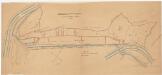
Kyburg, Töss, Illnau-Effretikon (damals Illnau), Schlatt: Staatswaldung: Kyburg: Durch den Staat angekaufte Waldstücke der Firma Hermann Bühler und Cie. bei Mühlau; Grundriss
1 : 1000 Kopie eines im Jahr 1934 von unbekannter Autorschaft verfertigten Originalplans. Mit Angabe der bisherigen Staatswaldung und der Ankäufe sowie mit Angabe der Namen von privaten Grundeigentümern. Mit nachträglichen Eintragungen und farbigen Einzeichnungen.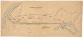
Kyburg, Töss, Illnau-Effretikon (damals Illnau), Schlatt: Staatswaldung: Kyburg: Durch den Staat angekaufte Waldstücke der Firma Hermann Bühler und Cie. bei Mühlau; Grundriss
1 : 1000 Kopie eines im Jahr 1934 von unbekannter Autorschaft verfertigten Originalplans. Mit Angabe der bisherigen Staatswaldung und der Ankäufe sowie mit Angabe der Namen von privaten Grundeigentümern. Ohne Erstellungsdatumsangabe. Mit nachträglichen Eintragungen und farbigen Einzeichnungen.
Kyburg, Seen: Bei Mühlau, Tösskorrektion; Situationsplan (Töss-Gebiet Nr. 20, Blatt 6)
1 : 1000 Kilometer 25.600 bis 27.150. Messtischblatt. Mit Angabe der Namen der Grundeigentümer. Ohne Datumsangabe.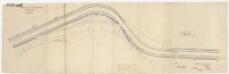
Kyburg, Seen: Oberhalb Sennhof, Tösskorrektion; Situationsplan (Töss-No. 51)
1 : 1000 Kilometer 25.155 bis 26.286. Huber, Hermann, Adjunkt des Kantonsingenieurs, von Dielsdorf Einsichtnahme: Wetli, Kaspar, andere Schreibweise: Wethli, (1822-1889), Kantonsingenieur, von Männedorf
Kyburg, Seen: Töss unterhalb der Brücke bei Sennhof; Situationsplan (Töss-Gebiet Nr. 2, Blatt 46)
1 : 1000 Kilometer 25.045 bis 25.675. Messtischblatt. Mit Angabe der Namen der Grundeigentümer. Ohne Datumsangabe. Peter, R.
Kyburg, Winterthur: Von oberhalb der Einmündung des Brülbachs bis Tössacker, Linsental, Tösskorrektion; Situationsplan (Töss-Gebiet Nr. 20, Blatt 7)
1 : 1000 Kilometer 26.300 bis 27.015. Messtischblatt. Mit Angabe der Namen der Grundeigentümer. Sieber, A.
Kyburg, Seen: Töss von unterhalb Howart (Ankenfelsen) bis zur Brücke bei Sennhof; Situationsplan (Töss-Gebiet Nr. 2, Blatt 45)
1 : 1000 Kilometer 24.430 bis 25.045. Messtischblatt. Mit Angabe der Namen der Grundeigentümer. Peter, R.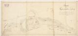
Kyburg, Töss, Illnau-Effretikon (damals Illnau), Schlatt: Staatswaldung: Kyburg: Tutschgenhalden (Tugsteinhalden); Grundriss (Nr. 18)
Teilweise erstellt auf der Basis der im Jahr 1817 von Kaspar Obrist, Forstmeister und Geometer, von Zollikon, durchgeführten Planaufnahme. Hertenstein, Jakob, Forstmeister des 2. Kreises des Kantons Zürich, von Kyburg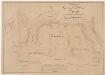
Seen: Gemeindewaldung: Nübrechten (Neubrechten); Grundriss
1 : 2400 Mit handschriftlichen Eintragungen und Einzeichnungen, welche nach der eigentlichen Zeichnung des Plans, d. h. nach 1839, mit Tinte und Grafitstift angebracht wurden. Auftraggebung: Forstkommission Aufnahme und Zeichnung: Hertenstein, Jakob, Forstmeister des 2. Kreises des Kantons Zürich, von Kyburg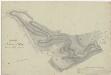
Kyburg, Töss, Illnau-Effretikon (damals Illnau), Schlatt: Staatswaldung: Kyburg: Leimenegg; Grundriss (Nr. 19)
Mit handschriftlichen Eintragungen und Einzeichnungen, welche nach der eigentlichen Zeichnung des Plans, d. h. nach 1817, angebracht wurden. Obrist, Kaspar (1791-1869), Forstmeister und Geometer, von Zollikon
Kyburg, Winterthur: Von Tössacker bzw. Linsental bis Sennschür, Tösskorrektion; Situationsplan (Töss-Gebiet Nr. 20, Blatt 8)
1 : 1000 Kilometer 26.990 bis 27.720. Messtischblatt.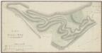
Kyburg, Töss, Illnau-Effretikon (damals Illnau), Schlatt: Staatswaldung: Kyburg: Leimenegg, Brünggberg; Grundriss
Mit handschriftlichen Eintragungen und Einzeichnungen, welche nach der eigentlichen Zeichnung des Plans, d. h. nach 1817, angebracht wurden. Obrist, Kaspar (1791-1869), Forstmeister und Geometer, von Zollikon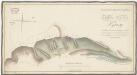
Kyburg, Töss, Illnau-Effretikon (damals Illnau), Schlatt: Staatswaldung: Kyburg: Tutschgenhalden (Tugsteinhalden); Grundriss
Teilweise erstellt auf der Basis der im Jahr 1817 von Kaspar Obrist, Forstmeister und Geometer, von Zollikon, durchgeführten Planaufnahme. Hertenstein, Jakob, Forstmeister des 2. Kreises des Kantons Zürich, von Kyburg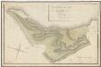
Kyburg: Leimenegg; Grundriss
1 : 2400 Erstellt auf der Basis eines im Jahr 1817 von Kaspar Obrist, Forstmeister und Geometer, von Zollikon, aufgenommenen Originalplans. Mit handschriftlichen Eintragungen und Einzeichnungen, welche nach der eigentlichen Zeichnung des Plans, d. h. nach 1823, mit roter Tinte und Grafitstift angebracht wurden. Hertenstein, Jakob, von Kyburg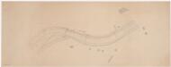
Kyburg, Seen: Töss bei Sennhof, Syphon; Situationsplan (Töss-Gebiet Nr. 53)
1 : 1000 Kilometer 24.500 bis 25.100. Ohne Datumsangabe.
Kyburg, Seen: Von Sennhof bis unterhalb der Einmündung des Beerentalbachs, Tösskorrektion; Situationsplan (Töss-Gebiet Nr. 20, Blatt 5)
1 : 1000 Kilometer 24.990 bis 25.620. Messtischblatt. Mit Angabe der Namen der Grundeigentümer. Ohne Datumsangabe.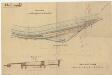
Kyburg, Winterthur: Töss bei Linsental, Ablaufkanal; Situationsplan und Querschnitt (Töss-No. 6)
1 : 1000 Handgezeichnete Kopie einer von Löffler, Ingenieur, angefertigten Zeichnung. Kilometer 26.930 bis 27.300. Ohne Datumsangabe.