Maps of Fischenthal

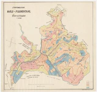
Wald, Fischenthal, Goldingen SG: Waldungen: Wald, Fischenthal: Staatswaldungen Warten, Stralegg (Strahlegg), Schürli, Hübschegg, Dägelsberg, Tösswald, Hüttkopf, Vorderhessen, Hinterhessen, Tössstock; Übersichtsplan
1 : 5000 Erstellt auf der Basis von in den Jahren 1908 und 1927 angefertigten Plänen. Mit Angabe des Alters des Baumbestands. Zeichnung: Gamma, P.
Wald, Fischenthal, Goldingen SG: Waldungen: Wald, Fischenthal: Staatswaldungen Warten, Stralegg (Strahlegg), Schürli, Hübschegg, Dägelsberg, Tösswald, Hüttkopf, Vorderhessen, Hinterhessen, Tössstock; Übersichtsplan
1 : 5000 Erstellt auf der Basis von in den Jahren 1908 und 1927 angefertigten Plänen. Mit farbigen Einzeichnungen der kluppierten, d. h. vermessenen, Waldbestände. Zeichnung: Gamma, P.
Wald, Fischenthal, Goldingen SG: Waldungen: Wald, Fischenthal: Staatswaldungen Stralegg (Strahlegg), Warten, Schürli, Hübschegg, Dägelsberg, Tösswald, Hüttkopf, Vorderhessen, Hinterhessen, Momilchgubel (Mondmilchgubel), Tössstock; Grundriss
1 : 5000 Mit Verzeichnis der Flächeninhalte der Waldabteilungen 10 bis 37 und mit Angaben der Zugänglichkeit der einzelnen Waldabteilungen.
Wald, Fischenthal, Goldingen SG: Waldungen: Wald, Fischenthal: Staatswaldungen Stralegg (Strahlegg), Warten, Schürli, Hübschegg, Dägelsberg, Tösswald, Hüttkopf, Vorderhessen, Hinterhessen, Momilchgubel (Mondmilchgubel), Tössstock; Übersichtsplan
1 : 5000 Erstellt auf der Basis von in den Jahren 1908 und 1927 angefertigten Plänen. Mit Verzeichnis der Flächeninhalte der 37 Abteilungen. Zeichnung: Gamma, P. Nachführung: Dübendorfer, J., Forstingenieur
Wald, Fischenthal, Goldingen SG: Waldungen: Wald, Fischenthal: Staatswaldungen Tösswald, Vorderhessen, Hinterhessen, Momilchgubel (Mondmilchgubel), Väsperrous (Vesperruns), Tössstock, Niderhusers (Niederhausers), Schürli, Neurütiwald, Stralegg (Strahlegg), Warten; Übersichtsplan (Bestandeskarte)
1 : 5000 Mit Angabe der Beschaffenheit und des Alters des Baumbestands. Steiner, D.
Wald, Fischenthal, Goldingen SG: Waldungen: Wald, Fischenthal: Staatswaldungen Vorderhessen, Hinterhessen, Momilchgubel (Mondmilchgubel), Väsperrous (Vesperruns), Tössstock, Niderhusers (Niederhausers), Schürli, Hübschegg, Tobelbueben; Übersichtsplan (Bestandeskarte)
1 : 5000 Mit Angabe der Beschaffenheit und des Alters des Baumbestands.
Fischenthal, Goldingen SG: Waldungen: Fischenthal: Staatswaldungen Stralegg (Strahlegg), Steg; Grundriss
1 : 5000 Mit zwei Verzeichnissen der Flächeninhalte.
Fischenthal, Goldingen SG: Waldungen: Fischenthal: Staatswaldungen Stralegg (Strahlegg), Steg; Grundriss
1 : 5000 Mit zwei Verzeichnissen der Flächeninhalte.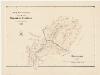
Fischenthal, Wald: Staatswaldungen am Tössstock und am Schnebelhorn; Übersichtsplan
1 : 5000 Mit Höhenkurven. Druck und Verlag: Hofer und Co., in Zürich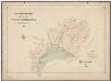
Wald, Fischenthal, Goldingen SG: Waldungen: Wald, Fischenthal: Staatswaldungen an Tössstock und Schnebelhorn im Jahr 1908; Übersichtsplan
1 : 5000 Mit Angabe des alten Tössstockgebiets, der Ankäufe seit 1892 sowie der entsprechenden Flächeninhalte. Druck und Verlag: Hofer und Co., in Zürich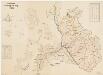
Fischenthal, Goldingen SG: Waldungen: Fischenthal: Staatswaldungen Stralegg (Strahlegg), Steg; Grundriss
1 : 5000 Mit zwei Verzeichnissen der Flächeninhalte.
Wald, Fischenthal, Goldingen SG: Waldungen: Wald, Fischenthal: Staatswaldungen Warten, Schürli, Hübschegg, Dägelsberg, Tösswald, Hüttkopf, Vorderhessen, Hinterhessen, Momilchgubel (Mondmilchgubel), Tössstock, Väsperrous (Vesperruns); Grundriss
1 : 5000 Mit Angabe des Flächeninhalts und farblichen Hervorhebungen der Ankäufe in den Jahren 1892 bis 1950. Ohne Erstellungsdatumsangabe. Ausgangsplan: Grundriss der Staatswaldung Wald-Fischenthal (Plan auf der Basis der im Jahr 1908 erstellten Vermessungspläne und der topographischen Karte im Massstab 1 : 25000). Zeichnung: Wettstein, Edwin, Forstadjunkt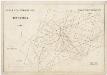
Wald, Fischenthal, Goldingen SG: Waldungen: Wald, Fischenthal: Staatswaldung Tössstock; Grundriss (Blatteinteilung)
1 : 5000 Erstellt auf der Basis eines im Jahr 1903 angefertigten Plans. Mit Legende der verwendeten Farben. Zeichnung: Honegger, R., Konkordatsgeometer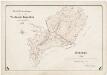
Wald, Fischenthal, Goldingen SG: Waldungen: Wald, Fischenthal: Staatswaldungen an Tössstock und Schnebelhorn im Jahr 1908; Übersichtsplan
1 : 5000 Zeichnung: Honegger, R., Konkordatsgeometer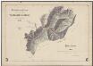
Wald, Fischenthal, Goldingen SG: Waldungen: Wald, Fischenthal: Staatswaldungen an Tössstock und Schnebelhorn im Jahr 1908; Übersichtsplan
1 : 5000 Druck und Verlag vermutlich: Hofer und Co., in Zürich
Wald, Fischenthal, Goldingen SG: Waldungen: Wald, Fischenthal: Staatswaldungen Warten, Schürli, Hübschegg, Dägelsberg, Tösswald, Hüttkopf, Vorderhessen, Hinterhessen, Momilchgubel (Mondmilchgubel), Tössstock, Väsperrous (Vesperruns); Grundriss
1 : 5000 Mit farblichen Hervorhebungen der Aufforstungen von ehemals offenem Land sowie altem Waldareal. Ohne Erstellungsdatumsangabe. Ausgangsplan: Grundriss der Staatswaldung Wald-Fischenthal (Plan auf der Basis der im Jahr 1908 erstellten Vermessungspläne und der topographischen Karte im Massstab 1 : 25000). Ausgangsplan Zeichnung: Wettstein, Edwin, Forstadjunkt im Zürcher Oberforstamt, von Pfäffikon, in Zürich
Wald, Fischenthal, Goldingen SG: Waldungen: Wald, Fischenthal: Aufforstungsgebiet in der Staatswaldung Tössstock mit Neuweg, Tobelrüti, Hübschegg, Schürli, Sennschür; Grundriss
1 : 10000 Mit Angabe der verwendeten Zeichen und Farben. Mit Einzeichnung und Eintragung der Neuankäufe in den Jahren 1898 und 1899 und mit Angabe der Namen der ehemaligen Grundeigentümer. Aufnahme und Zeichnung: Honegger, Huldreich, Forstadjunkt im Zürcher Oberforstamt, von Zürich, in Zürich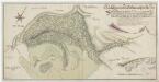
Grenze zwischen der Landvogtei Grüningen und der Grafschaft Uznach beim Tössstock und der Boalp (ältere Schreibweise: Poo-Alp) von der Wolfsgrube bis zum Oberen Dägelsberg; Grundriss
Mit Legende und einem Siegel der zürcherischen Staatskanzlei. Müller, Johannes (1733-1816), obrigkeitlicher Ingenieur des Zürcher Stadtstaats, von Zürich
Goldingen SG, Wald, Fischenthal: Vordere und hintere Töss, Einzugsgebiet; Übersichtskarte und Querprofile
1 : 25000 Handgezeichnete Kopie eines im März 1901 von J. Pfister, Bauführer, verfertigten Originalplans. Kopie: Manz, E.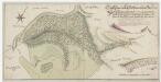
Grenze zwischen der Landvogtei Grüningen und der Grafschaft Uznach beim Tössstock und der Boalp (ältere Schreibweise: Poo-Alp) von der Wolfsgrube bis zum Oberen Dägelsberg; Grundriss
Mit Legende und einem Siegel der zürcherischen Staatskanzlei. Müller, Johannes (1733-1816), obrigkeitlicher Ingenieur des Zürcher Stadtstaats, von Zürich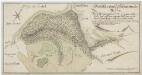
Grenze zwischen der Landvogtei Grüningen und der Grafschaft Uznach beim Tössstock und der Boalp (ältere Schreibweise: Poo-Alp) von der Wolfsgrube bis zum Oberen Dägelsberg; Grundriss
Mit Legende. Müller, Johannes (1733-1816), obrigkeitlicher Ingenieur des Zürcher Stadtstaats, von Zürich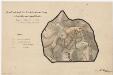
Wald, Fischenthal, Goldingen SG: Waldungen: Fischenthal: Landankäufe der Staatsforstverwaltung im Gebiet Schnebelhorn, Schwämmibach (Schwemmibach), Tobelrüti, Sennschür, Neuschür, Hübschegg, Neurüti und Tierhag; Grundriss
1 : 10000 Mit Legende zu den verwendeten Farben. Mit Angabe der Namen der Grundeigentümer. Aufnahme und Zeichnung: Honegger, Huldreich, Forstadjunkt im Zürcher Oberforstamt, von Zürich, in Zürich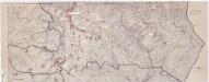
Fischenthal: Definition der Siedlungen für die eidgenössische Volkszählung am 01.12.1970; Siedlungskarte: Teilkarte 2: Südlicher Teil
1 : 5000 Auf Ausgangskarte angebrachte farbige Einzeichnungen und Eintragungen. Mit Legende. Ohne Erstellungsdatumsangabe. Vermutlich: S., R.
Wald, Fischenthal, Goldingen SG: Waldungen: Wald, Fischenthal: Staatswaldungen Warten, Schürli, Hübschegg, Dägelsberg, Tösswald, Hüttkopf, Vorderhessen, Hinterhessen, Tössstock; Übersichtsplan (Bestandeskarte)
1 : 5000 Mit Angabe der Beschaffenheit und des Alters des Baumbestands.
Wald, Fischenthal, Goldingen SG: Waldungen: Wald, Fischenthal: Staatswaldungen Tössstock, Schnebelhorn, Neuweg, Tobelrüti, Hübschegg; Grundriss
1 : 10000 Mit Angabe der verwendeten Zeichen und Farben. Aufnahme und Zeichnung: Rüedi, Karl, Forstadjunkt im Zürcher Oberforstamt, von Fisibach AG, in Zürich
Grenze zwischen der Landvogtei Grüningen und der Grafschaft Uznach beim Tössstock und der Boalp (ältere Schreibweise: Poo-Alp) von der Wolfsgrube bis zum Bach Tollen; Grundriss
Mit Legende. Walder, Joh. H.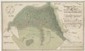
Grenze zwischen der Landvogtei Grüningen und der Grafschaft Uznach beim Tössstock und der Boalp (ältere Schreibweise: Poo-Alp) von der Wolfsgrube bis zum Mittleren Dägelsberg; Grundriss
Mit Legende. Albertin, Johann Heinrich (1713-1790), Vermesser, Kartograf und Artilleriehauptmann, von Zürich
Wald, Fischenthal, Goldingen SG: Waldungen: Wald, Fischenthal: Staatswaldung Beicher (Ankauf der Parzelle Hinter-Beicher); Grundriss
1 : 5000 Mit Legende der verwendeten Farben und Zeichen. Mit Angabe des Namens eines Grundeigentümers. Ohne Datumsangabe. Ausgangsplan: Übersichtsplan der Staatswaldung Wald-Fischenthal (Ausschnitt).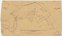
Wald, Fischenthal, Goldingen SG: Waldungen: Fischenthal: Vom Staat angekaufte Privatliegenschaft von A. Bachmann am Schnebelhorn; Grundriss
Mit roten Einzeichnungen der Parzellen, welche nach dem Abtausch dem Staat gehörten. Aufnahme und Zeichnung: Honegger, Huldreich, Forstadjunkt im Zürcher Oberforstamt, von Zürich, in Zürich