Maps of Fischenthal

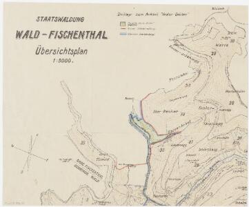
Wald, Fischenthal, Goldingen SG: Waldungen: Wald, Fischenthal: Staatswaldung Beicher (Ankauf der Parzelle Hinter-Beicher); Grundriss
1 : 5000 Mit Legende der verwendeten Farben und Zeichen. Mit Angabe des Namens eines Grundeigentümers. Ohne Datumsangabe. Ausgangsplan: Übersichtsplan der Staatswaldung Wald-Fischenthal (Ausschnitt).
Fischenthal, Goldingen SG: Waldungen: Fischenthal: Staatswaldungen Bruederegg, Stierweid, Lauf; Grundriss
1 : 2000 Mit Angabe der Namen der Grundeigentümer. Ohne Datumsangabe.
Wald, Fischenthal, Goldingen SG: Waldungen: Wald: Staatswaldung am Tössstock mit Bruederegg und Tösswald; Grundriss
1 : 2000 Aufnahme: Honegger, Huldreich, Forstadjunkt im Zürcher Oberforstamt, von Zürich, in Zürich
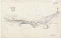
Fischenthal: Obere Töss bei der hinteren Stierweid, Tösskorrektion; Situationsplan (Töss-Gebiet Nr. 8, Blatt 1)
1 : 2000 Kilometer -4.600 bis -3.850. Messtischblatt. Aufnahme: Fritschi, Em., Geometer
Wald, Fischenthal, Goldingen SG: Waldungen: Fischenthal: Staatswaldungen Matisen, Ghoggweid, Tösswald, Laufegg, Bruederegg, Cholgrueb, Oberegg, Stuck, Hagelacher; Grundriss
1 : 2000 Mit Verzeichnis der Flächeninhalte. Ausgangsplan: Grundbuchplan 32 der Gemeinde Fischenthal. Aufnahme und Zeichnung: Metzger, Otto, Grundbuchgeometer, in Stäfa
Fischenthal, Goldingen SG: Waldungen: Fischenthal: Staatswaldungen Stralegg (Strahlegg), Warten, Hinter Warten, Vorderschür, Bärloch, Früetobel, Chleger; Grundriss
1 : 2000 Mit Angabe der Namen der Grundeigentümer. Ohne Datumsangabe.
Fischenthal, Goldingen SG: Waldungen: Fischenthal: Staatswaldungen Stralegg (Strahlegg), Warten, Hinter Warten, Vorderschür, Bärloch, Früetobel, Chleger; Grundriss
1 : 2000 Mit Angabe der Namen der Grundeigentümer. Ohne Datumsangabe.
Fischenthal: Obere Töss von der Stierweid bis unterhalb Chleger, Tösskorrektion; Situationsplan (Töss-Gebiet Nr. 8, Blatt 2)
1 : 2000 Kilometer -3.850 bis 2.760. Messtischblatt. Aufnahme: Fritschi, Em., Geometer
Wald, Fischenthal, Goldingen SG: Waldungen: Fischenthal: Staatswaldung Schnebelhorn; Grundriss (Originalplan Nr. 1)
1 : 2000 Zeichnung: Honegger, R., Konkordatsgeometer
Wald, Fischenthal, Goldingen SG: Waldungen: Fischenthal: Staatswaldung Schnebelhorn; Grundriss (Reinplan Nr. 1)
1 : 2000 Zeichnung: Honegger, R., Konkordatsgeometer
Wald, Fischenthal, Goldingen SG: Waldungen: Fischenthal: Privatgrundstücke in den Abschnitten Tierhag, Tobelrüti, Hübschegg, Duntenegg (Tuntenegg), Sennhütte, Schürli, Neuschür, Sennschür; Grundriss
1 : 5000 Mit drei Verzeichnissen der privaten Waldparzellen von Heinrich, Albert und Rudolf Ryser. Ohne Datumsangabe. Aufnahme und Zeichnung: Honegger, Huldreich, Forstadjunkt im Zürcher Oberforstamt, von Zürich, in Zürich
Wald, Fischenthal, Goldingen SG: Waldungen: Fischenthal: Staatswaldungen Mülischwand, Schwämmi, Tösswald, Stierweid, Tannen, Ghogg, Ghoggweid, Brandweid, Löcheren, Matisen, Hinteraurüti; Grundriss
1 : 2000 Mit Verzeichnis der Flächeninhalte. Ausgangsplan: Grundbuchplan 31 der Gemeinde Fischenthal. Aufnahme und Zeichnung: Metzger, Otto, Grundbuchgeometer, in Stäfa
Rüti: Dem Amt Rüti gehörende Waldung zu Rüti (Waldbezirke Scheideggholz, Gächhölzli und Gestellholz; Grundrisse (V. Planche)
Mit Verzeichnis der Beschaffenheit der Waldung bei der Visitation 1794 sowie der jährlichen Holzabgabe und Anpflanzung 1803-1811. Aufnahme: Hotz, Heinrich (1768-1813), Forstmeister des Kantons Zürich, von Oberrieden Zeichnung: Diezinger, Rudolf (1770-1847), Geometer, von Wädenswil, in Wädenswil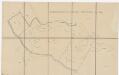
Wald, Fischenthal, Goldingen SG: Waldungen: Fischenthal: Arrondierungsvorlage Tösswald; Grundriss
1 : 2000 Mit Angabe des Flächeninhalts und der Namen der Grundeigentümer. Aufnahme und Zeichnung: Huber, Konrad, Forstassistent im Zürcher Oberforstamt, von Zürich, in Zürich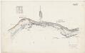
Fischenthal: Obere Töss von Bruderegg bis Hinterer Beicher; Situationsplan (Blatt V)
1 : 1000 Kilometer -5.450 bis -5.050. Messtischblatt. Mit Koordinatentafel. Aufnahme und Ausarbeitung: Jsler, R., Geometer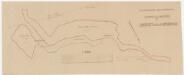
Wald, Fischenthal, Goldingen SG: Waldungen: Fischenthal: Staatswaldungen Bruederegg, Überzütt; Grundriss
1 : 2000 Mit Angabe der Flächeninhalte und mit Eintragungen von Ankäufen in den Jahren 1909 und 1911. Aufnahme und Zeichnung: Wettstein, Edwin, Forstadjunkt im Zürcher Oberforstamt, von Pfäffikon, in Zürich
Wald, Fischenthal, Goldingen SG: Waldungen: Fischenthal: Staatswaldung Schürli (Rodungsfläche am Schürlihang); Situationsplan
1 : 5000 Ohne Datumsangabe.
Wald, Fischenthal, Goldingen SG: Waldungen: Fischenthal, Wald: Ankaufsprojekt J. Peter in den Abschnitten Bärloch, Warten, Vorderstralegg (Strahlegg), Burenboden; Grundriss
1 : 2000 Mit Legende zu den aufgeforsteten und unbestockt gebliebenen Abschnitten, mit Angabe der verwendeten Farben sowie mit Verzeichnis der Flächeninhalte. Aufnahme und Zeichnung: Huber, Konrad, Forstassistent im Zürcher Oberforstamt, von Zürich, in Zürich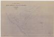
Fischenthal, Goldingen SG: Waldungen: Fischenthal: Im Waldabschnitt Beicher gelegene Privatliegenschaft von Heinrich Brandenberger; Situationsplan
1 : 2000 Mit Angabe der Namen der Grundeigentümer. Ohne Datumsangabe. Aufnahme und Zeichnung: Metzger, Otto, Grundbuchgeometer, in Stäfa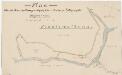
Wald, Fischenthal, Goldingen SG: Waldungen: Wald: Privatwaldungen Schoch und Brandenberger bei der Tössscheidi; Grundriss
1 : 2000 Aufnahme und Zeichnung: Honegger, Huldreich, Forstadjunkt im Zürcher Oberforstamt, von Zürich, in Zürich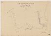
Wald, Fischenthal, Goldingen SG: Waldungen: Fischenthal: Staatswaldung Tössstock; Grundriss 10
1 : 1000 Aufnahme und Zeichnung: Honegger, R., Konkordatsgeometer
Wald, Fischenthal: Hintere Töss von oberhalb bis unterhalb der Einmündung des Tobelrütibachs; Situationsplan (Blatt 2)
1 : 1000 Messtischblatt. Aufnahme: Pfister, Joh.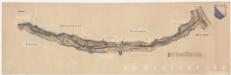
Wald, Fischenthal: Vordere Töss von Gubel bis zur Bachscheide; Situationsplan
1 : 1000 Kilometer -0.900 bis 0.000. Ohne Datumsangabe.
Goldingen SG, Wald, Fischenthal: Von der Grenze zwischen den Kantonen St. Gallen und Zürich bis zur Bachscheide, Korrektion der Hinteren Töss, Ausführung 1900-1902; Situationsplan
1 : 1000 Kilometer -7.100 bis -5.800. Ohne Datumsangabe.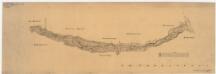
Wald, Fischenthal: Vordere Töss von Im Gubel bis zur Einmündung der hinteren Töss; Situationsplan
1 : 1000 Handgezeichnete Kopie eines im Oktober 1899 von J. Pfister verfertigten Originalplans. Messtischblatt. Kopie: Sandrin, L.
Goldingen SG, Wald, Fischenthal: Hintere Töss von der Grenze zwischen den Kantonen St. Gallen und Zürich bis zur Einmündung der Vorderen Töss, Absteckung; Situationsplan
1 : 1000 Kilometer -7.100 bis -5.700. Ohne Datumsangabe.
Fischenthal, Goldingen SG: Waldungen: Fischenthal: Wasserversorgung zum Schulhausneubau in der Vorderstrahlegg, Grundriss
Mit Angabe der verwendeten Zeichen. Aufnahme und Zeichnung: Ae., W.
Fischenthal, Goldingen SG: Waldungen: Fischenthal: Angekaufte, an die Staatswaldung stossende Parzellen von Paul Widmer von Werner Kägi in der Stralegg bei der Vorderen Warten; Grundriss
1 : 2000 Vgl. Regierungsratsbeschluss Nr. 2231 vom 12.07.1956.
Wald, Fischenthal, Goldingen SG: Waldungen: Fischenthal: Staatswaldung Tössstock; Grundriss 11
1 : 1000 Aufnahme und Zeichnung: Honegger, R., Konkordatsgeometer