Maps of Dolany

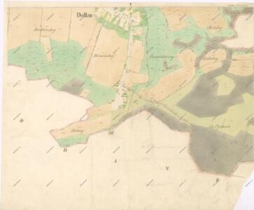
Indikační skica mapy stabilního katastru pro obec Dolany V.
1 : 2880
Mapa pozemků bývalého Bohdanečského rybníka Bl[att] 2
1 : 5000
Hospodářská mapa revíru Šviholec
1 : 5000
Porostní mapa revíru Šviholec
1 : 5000
Hospodářská mapa lesa Šviholec
1 : 5000
Hospodářská mapa revíru Šviholec
1 : 2880
Hospodářská mapa revíru Šviholec
1 : 2880
Mapa probírek a čistících sečí hájemství Šviholec
1 : 5000
Porostní mapa revíru Šviholec
1 : 5000
Hospodářská mapa revíru Šviholec
1 : 2880
Mapa probírek revíru Stéblová
1 : 5000
Dollan - c1239-1-004 - Kaiserpflichtexemplar der Landkarten des stabilen Katasters
1 : 2880
Dollan - c1239-1-003 - Kaiserpflichtexemplar der Landkarten des stabilen Katasters
1 : 2880
Dollan - c1239-1-002 - Kaiserpflichtexemplar der Landkarten des stabilen Katasters
1 : 2880
Dollan - c1239-1-001 - Kaiserpflichtexemplar der Landkarten des stabilen Katasters
1 : 2880
Hospodářská mapa revíru Stéblová
1 : 5000
Porostní mapa revíru Opatovice Sekce III.
1 : 3000
Porostní mapa revíru Šviholec
1 : 10000
Indikační skica mapy stabilního katastru pro obec Staré Ždánice a osadu Nové Ždánice I.-V.
1 : 2880
Zdanitz - c7283-1-002 - Kaiserpflichtexemplar der Landkarten des stabilen Katasters
1 : 2880
Zdanitz - c7283-1-003 - Kaiserpflichtexemplar der Landkarten des stabilen Katasters
1 : 2880
Zdanitz - c7283-1-004 - Kaiserpflichtexemplar der Landkarten des stabilen Katasters
1 : 2880
Zdanitz - c7283-1-001 - Kaiserpflichtexemplar der Landkarten des stabilen Katasters
1 : 2880
Indikační skica mapy stabilního katastru pro obec Staré Ždánice a osadu Nové Ždánice V.
1 : 2880
Koncept mapy části Opatovického revíru, tzv. Plchovské olšiny
1 : 2600
Indikační skica mapy stabilního katastru pro obec Dolany IV.
1 : 2880
Mapa pozemků bývalého Bohdanečského rybníka Bl[att] 1
1 : 5000
Indikační skica mapy stabilního katastru pro obec Dolany VI.
1 : 2880
Porostní mapa revíru Stéblová
1 : 10000