Maps of Břehy

Indikační skica mapy stabilního katastru pro obec Břehy V.
1 : 2880
Indikační skica mapy stabilního katastru pro město Přelouč II.
1 : 2880
Indikační skica mapy stabilního katastru pro obec Semín ad II.
1 : 2880
Indikační skica mapy stabilního katastru pro město Přelouč I.-VIII.
1 : 2880
Brzech - c0549-1-006 - Kaiserpflichtexemplar der Landkarten des stabilen Katasters
1 : 2880
Brzech - c0549-1-003 - Kaiserpflichtexemplar der Landkarten des stabilen Katasters
1 : 2880
Brzech - c0549-1-005 - Kaiserpflichtexemplar der Landkarten des stabilen Katasters
1 : 2880
Brzech - c0549-1-004 - Kaiserpflichtexemplar der Landkarten des stabilen Katasters
1 : 2880
Brzech - c0549-1-002 - Kaiserpflichtexemplar der Landkarten des stabilen Katasters
1 : 2880
Brzech - c0549-1-001 - Kaiserpflichtexemplar der Landkarten des stabilen Katasters
1 : 2880
Przelautsch (Przelaucz) - c6194-1-005 - Kaiserpflichtexemplar der Landkarten des stabilen Katasters
1 : 2880
Przelautsch (Przelaucz) - c6194-1-006 - Kaiserpflichtexemplar der Landkarten des stabilen Katasters
1 : 2880
Przelautsch (Przelaucz) - c6194-1-003 - Kaiserpflichtexemplar der Landkarten des stabilen Katasters
1 : 2880
Przelautsch (Przelaucz) - c6194-1-004 - Kaiserpflichtexemplar der Landkarten des stabilen Katasters
1 : 2880
Przelautsch (Przelaucz) - c6194-1-002 - Kaiserpflichtexemplar der Landkarten des stabilen Katasters
1 : 2880
Przelautsch (Przelaucz) - c6194-1-007 - Kaiserpflichtexemplar der Landkarten des stabilen Katasters
1 : 2880
Przelautsch (Przelaucz) - c6194-1-001 - Kaiserpflichtexemplar der Landkarten des stabilen Katasters
1 : 2880
Semin - c6831-1-001 - Kaiserpflichtexemplar der Landkarten des stabilen Katasters
1 : 2880
Semin - c6831-1-004 - Kaiserpflichtexemplar der Landkarten des stabilen Katasters
1 : 2880
Semin - c6831-1-002 - Kaiserpflichtexemplar der Landkarten des stabilen Katasters
1 : 2880
Semin - c6831-1-005 - Kaiserpflichtexemplar der Landkarten des stabilen Katasters
1 : 2880
Semin - c6831-1-003 - Kaiserpflichtexemplar der Landkarten des stabilen Katasters
1 : 2880
Indikační skica mapy stabilního katastru pro obec Lhota pod Přeloučí I.-IV.
1 : 2880
Porostní mapa polesí Semín
1 : 10000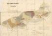
Porostní mapa revíru Semín
1 : 5000
Indikační skica mapy stabilního katastru pro město Přelouč I.
1 : 2880
Indikační skica mapy stabilního katastru pro obec Semín IV.
1 : 2880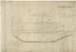
Mapa pozemků bývalého Břežského rybníka
1 : 2918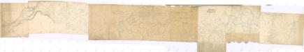
Situační plán řeky Labe od Přelouče po Týnec nad Labem
1 : 3161