Maps of Pustá Rybná

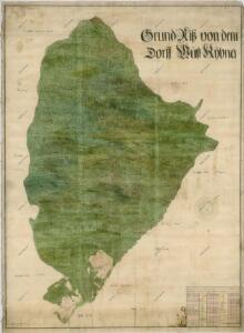
Mapa vsi Pustá Rybná
1 : 3758
Mapa revíru Milovy
1 : 10000
Wüst Kamenitz (Pusta Kamenice) - c6285-1-005 - Kaiserpflichtexemplar der Landkarten des stabilen Katasters
1 : 2880
Wüst Kamenitz (Pusta Kamenice) - c6285-1-007 - Kaiserpflichtexemplar der Landkarten des stabilen Katasters
1 : 2880
Wüst Kamenitz (Pusta Kamenice) - c6285-1-006 - Kaiserpflichtexemplar der Landkarten des stabilen Katasters
1 : 2880
Wüst Kamenitz (Pusta Kamenice) - c6285-1-001 - Kaiserpflichtexemplar der Landkarten des stabilen Katasters
1 : 2880
Wüst Kamenitz (Pusta Kamenice) - c6285-1-002 - Kaiserpflichtexemplar der Landkarten des stabilen Katasters
1 : 2880
Wüst Kamenitz (Pusta Kamenice) - c6285-1-004 - Kaiserpflichtexemplar der Landkarten des stabilen Katasters
1 : 2880
Wüst Kamenitz (Pusta Kamenice) - c6285-1-008 - Kaiserpflichtexemplar der Landkarten des stabilen Katasters
1 : 2880
Wüst Kamenitz (Pusta Kamenice) - c6285-1-003 - Kaiserpflichtexemplar der Landkarten des stabilen Katasters
1 : 2880
Hospodářská mapa polesí Bukovina
1 : 5000
Brzezin - c0586-1-002 - Kaiserpflichtexemplar der Landkarten des stabilen Katasters
1 : 2880
Brzezin - c0586-1-007 - Kaiserpflichtexemplar der Landkarten des stabilen Katasters
1 : 2880
Brzezin - c0586-1-005 - Kaiserpflichtexemplar der Landkarten des stabilen Katasters
1 : 2880
Brzezin - c0586-1-006 - Kaiserpflichtexemplar der Landkarten des stabilen Katasters
1 : 2880
Brzezin - c0586-1-001 - Kaiserpflichtexemplar der Landkarten des stabilen Katasters
1 : 2880
Brzezin - c0586-1-003 - Kaiserpflichtexemplar der Landkarten des stabilen Katasters
1 : 2880
Brzezin - c0586-1-004 - Kaiserpflichtexemplar der Landkarten des stabilen Katasters
1 : 2880
Mapa revíru Pustá Kamenice a okrsků Františky a Lubná
1 : 10000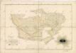
Mapa vsí Čachnov a Ruda
1 : 2918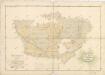
Mapa rolí vsí Čachnov a Ruda
1 : 2918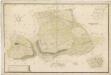
Mapa dominikálních vsí Čachnov, Ruda a Pec
1 : 2371
Cikanka - c0945-1-002 - Kaiserpflichtexemplar der Landkarten des stabilen Katasters
1 : 2880
Cikanka - c0945-1-001 - Kaiserpflichtexemplar der Landkarten des stabilen Katasters
1 : 2880
Tschachnow (Czachnow) - c0779-1-001 - Kaiserpflichtexemplar der Landkarten des stabilen Katasters
1 : 2880
Tschachnow (Czachnow) - c0779-1-003 - Kaiserpflichtexemplar der Landkarten des stabilen Katasters
1 : 2880
Tschachnow (Czachnow) - c0779-1-002 - Kaiserpflichtexemplar der Landkarten des stabilen Katasters
1 : 2880
Skica projektované silnice vedoucí přes polesí Bukovina
1 : 2880
Náčrt mapy dominikálních pozemků osady Damašek u Pusté Kamenice
1 : 3161