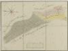
Maps of Suchdol nad Lužnicí

Suchdol nad Lužnicí o. Jindřichův Hradec 1
1 : 2880
Geometrický plán polesí Cep

Geometrický plán lesů Spálený, Vejpustek pod Smolkem a rybníků Smolek, Heřman a Joch s přilehlými činžovními pozemky

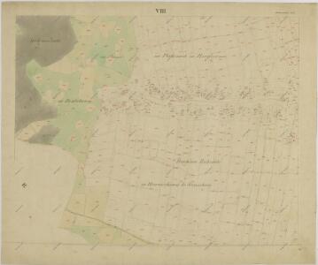
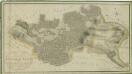
Suchenthal - c7551-1-007 - Kaiserpflichtexemplar der Landkarten des stabilen Katasters
1 : 2880
Suchenthal - c7551-1-005 - Kaiserpflichtexemplar der Landkarten des stabilen Katasters
1 : 2880
Suchenthal - c7551-1-006 - Kaiserpflichtexemplar der Landkarten des stabilen Katasters
1 : 2880
Suchenthal - c7551-1-010 - Kaiserpflichtexemplar der Landkarten des stabilen Katasters
1 : 2880
Suchenthal - c7551-1-009 - Kaiserpflichtexemplar der Landkarten des stabilen Katasters
1 : 2880
Suchenthal - c7551-1-002 - Kaiserpflichtexemplar der Landkarten des stabilen Katasters
1 : 2880
Suchenthal - c7551-1-004 - Kaiserpflichtexemplar der Landkarten des stabilen Katasters
1 : 2880
Suchenthal - c7551-1-001 - Kaiserpflichtexemplar der Landkarten des stabilen Katasters
1 : 2880
Suchenthal - c7551-1-003 - Kaiserpflichtexemplar der Landkarten des stabilen Katasters
1 : 2880
Suchenthal - c7551-1-008 - Kaiserpflichtexemplar der Landkarten des stabilen Katasters
1 : 2880
Porostní mapa polesí Hrdlořezy 1

Odvodňovací mapa polesí Hrdlořezy 1
1 : 10000
Porostní mapa polesí Hrdlořezy 1
1 : 10000
Porostní mapa polesí Hrdlořezy 1
1 : 10000
Hrdlořezy o. Jindřichův Hradec 1
1 : 2880
Geometrický plán polesí Cep

Hospodářská mapa polesí Cep 1
Geometrický plán lesů Spálenišťata a Vochoz u Boru s přilehlými činžovními pozemky
Geometrický plán lesů Spálenišťata a Vochoz u Boru s přilehlými činžovními pozemky

Porostní mapa polesí Cep 1

Porostní mapa polesí Cep 1

Hospodářská mapa polesí Hrdlořezy 1
1 : 2880
Hospodářská mapa polesí Hrdlořezy 1

Geometrický plán druhé části lesa Vochoz, dvora Synochov a přilehlých rybníků a vrchnostenských činžovních pozemků

Plán na stavbu nové hajnice 1
1 : 10
Porostní mapa polesí Hrdlořezy 1
1 : 15000