Maps of Novosedly nad Nežárkou

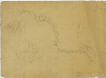
Záměrná mapa-brouillon-toku Nežárky od soutoku s Novou řekou po jednotáře Pánka

Val o. Tábor 1
1 : 2880
Půdorysné plány lesního úřadu, hájoven a mysliven na velkostatku Třeboň 1

Mapy činžovních pozemků I. sekce třeboňského velkostatku pro obce: Borkovice, Bošilec, Drahotěšice, Frahelž, Hamr, Horusice, Lhota, Líšnice, Mažice, Mezimostí, Ponědraž, Ponědrážka, Řípec, Val, Vlkov 1
1 : 2880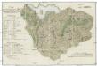
Parc seiner hoch gräflichen Gnaden des Herrn Herrn Grafen Rudolph von Czernin auf der Herrschaft Neuhaus bei Gestütthof in dem Koza und Hollnauer Forste
1 : 15500 Jemčina (Hatín, Česko)
Geometrický plán jednot tzv. Albrechtice a okolních vrchnostenských lesů a jiterních pozemků 1

Kollenetz - c3278-1-002 - Kaiserpflichtexemplar der Landkarten des stabilen Katasters
1 : 2880
Kollenetz - c3278-1-001 - Kaiserpflichtexemplar der Landkarten des stabilen Katasters
1 : 2880
Kollenetz - c3278-1-009 - Kaiserpflichtexemplar der Landkarten des stabilen Katasters
1 : 2880
Kollenetz - c3278-1-004 - Kaiserpflichtexemplar der Landkarten des stabilen Katasters
1 : 2880
Kollenetz - c3278-1-005 - Kaiserpflichtexemplar der Landkarten des stabilen Katasters
1 : 2880
Kollenetz - c3278-1-008 - Kaiserpflichtexemplar der Landkarten des stabilen Katasters
1 : 2880
Kollenetz - c3278-1-007 - Kaiserpflichtexemplar der Landkarten des stabilen Katasters
1 : 2880
Kollenetz - c3278-1-006 - Kaiserpflichtexemplar der Landkarten des stabilen Katasters
1 : 2880
Kollenetz - c3278-1-003 - Kaiserpflichtexemplar der Landkarten des stabilen Katasters
1 : 2880
Geometrický plán kolenecké obory, rybníků Prkenný a Mezenský, pastvin a luk 1

Val o. Tábor 1
1 : 2880
Kolence o. Jindřichův Hradec 1
1 : 2880
Geometrický plán lesa Vosiřín, rybníků Stejnej a Pohořelec a přilehlých činžovních pozemků 1

Generální mapa panství Třeboň a inkorporovaných statků Bzí, Lomnice, Borovany, Třeboň, Hamr a Val 1

Porostní mapa polesí Kolence 1
1 : 15000
Porostní mapa polesí Kolence 1
1 : 15000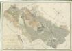
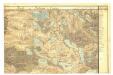
Přehledná mapa pozemků statku Hamr-Val a lesů koleneckého polesí 1

Situační plán statku Hamr-Val a přilehlých pozemků 1


Podrobné mapy zemí Koruny české v měřítku 1:75.000 a mapa vzdáleností všech míst při silnici ležících - Jindř. Hradec - Třeboň - N. Bystřice. Průvodce statisticko-historický po všech místech na těchto mapách uvedených a rejstřík věcný názvů hor, potoků, řek, rybníků atd. Sešit 49. List 73,
1 : 75000
III. vojenské mapování 4353
1 : 75000
Jindřichův Hradec a okolí
1 : 75000 Jindřichův Hradec (Česko : oblast) Vojenský zeměpisný ústav
Neuhaus
1 : 75000 Jindřichův Hradec (Česko : oblast) Ansion K. u. k. militär-geographisches Institut
Neuhaus
1 : 75000 Jindřichův Hradec (Česko : oblast) Ansion K. u. k. Militärgeographisches Institut