Maps of Novosedly nad Nežárkou

Kolence o. Jindřichův Hradec 1
1 : 2880
Val o. Tábor 1
1 : 2880
Geometrický plán kolenecké obory, rybníků Prkenný a Mezenský, pastvin a luk 1

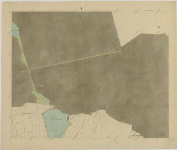
Kollenetz - c3278-1-002 - Kaiserpflichtexemplar der Landkarten des stabilen Katasters
1 : 2880
Kollenetz - c3278-1-001 - Kaiserpflichtexemplar der Landkarten des stabilen Katasters
1 : 2880
Kollenetz - c3278-1-009 - Kaiserpflichtexemplar der Landkarten des stabilen Katasters
1 : 2880
Kollenetz - c3278-1-004 - Kaiserpflichtexemplar der Landkarten des stabilen Katasters
1 : 2880
Kollenetz - c3278-1-005 - Kaiserpflichtexemplar der Landkarten des stabilen Katasters
1 : 2880
Kollenetz - c3278-1-008 - Kaiserpflichtexemplar der Landkarten des stabilen Katasters
1 : 2880
Kollenetz - c3278-1-007 - Kaiserpflichtexemplar der Landkarten des stabilen Katasters
1 : 2880
Kollenetz - c3278-1-006 - Kaiserpflichtexemplar der Landkarten des stabilen Katasters
1 : 2880
Kollenetz - c3278-1-003 - Kaiserpflichtexemplar der Landkarten des stabilen Katasters
1 : 2880
Situační plán kolenecké obory 1
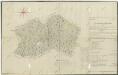
Geometrický plán kolenecké obory 1
Mapa území mezi třeboňským panstvím a činžovními pozemky vsi Kolence 1

Situační plán kolenecké obory 1
Geometrický plán jednot tzv. Albrechtice a okolních vrchnostenských lesů a jiterních pozemků 1
Záměrná mapa-brouillon-toku Nežárky od soutoku s Novou řekou po jednotáře Pánka

Mapy činžovních pozemků I. sekce třeboňského velkostatku pro obce: Borkovice, Bošilec, Drahotěšice, Frahelž, Hamr, Horusice, Lhota, Líšnice, Mažice, Mezimostí, Ponědraž, Ponědrážka, Řípec, Val, Vlkov 1
1 : 2880
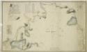
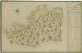
Generální mapa panství Třeboň a inkorporovaných statků Bzí, Lomnice, Borovany, Třeboň, Hamr a Val 1

Porostní mapa polesí Kolence 1
1 : 15000
Porostní mapa polesí Kolence 1
1 : 15000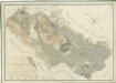
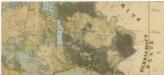
Přehledná mapa pozemků statku Hamr-Val a lesů koleneckého polesí 1
Administrativní mapa třeboňského panství se statky Bzí,Lomnice, Borovany,Hamr a Val 1
Situační plán statku Hamr-Val a přilehlých pozemků 1

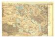
III. vojenské mapování 4353/4
1 : 25000
[Gradkartenblatt]
1 : 25000 Třeboň-oblast (Česko)
Gradkartenblatt
1 : 25000 Třeboň-oblast (Česko) Gerstner, Eduard von