Maps of Cehnice

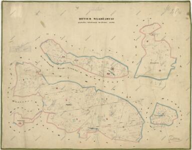
Hospodářská mapa revíru Mladějovice
1 : 5694
Mladiegowitz (Mladěgowitz) - c4737-1-003 - Kaiserpflichtexemplar der Landkarten des stabilen Katasters
1 : 2880
Mladiegowitz (Mladěgowitz) - c4737-1-005 - Kaiserpflichtexemplar der Landkarten des stabilen Katasters
1 : 2880
Mladiegowitz (Mladěgowitz) - c4737-1-001 - Kaiserpflichtexemplar der Landkarten des stabilen Katasters
1 : 2880
Mladiegowitz (Mladěgowitz) - c4737-1-002 - Kaiserpflichtexemplar der Landkarten des stabilen Katasters
1 : 2880
Mladiegowitz (Mladěgowitz) - c4737-1-004 - Kaiserpflichtexemplar der Landkarten des stabilen Katasters
1 : 2880
Czehnitz (Čehnic) - c0735-1-004 - Kaiserpflichtexemplar der Landkarten des stabilen Katasters
1 : 2880
Czehnitz (Čehnic) - c0735-1-007 - Kaiserpflichtexemplar der Landkarten des stabilen Katasters
1 : 2880
Czehnitz (Čehnic) - c0735-1-006 - Kaiserpflichtexemplar der Landkarten des stabilen Katasters
1 : 2880
Czehnitz (Čehnic) - c0735-1-005 - Kaiserpflichtexemplar der Landkarten des stabilen Katasters
1 : 2880
Czehnitz (Čehnic) - c0735-1-001 - Kaiserpflichtexemplar der Landkarten des stabilen Katasters
1 : 2880
Czehnitz (Čehnic) - c0735-1-002 - Kaiserpflichtexemplar der Landkarten des stabilen Katasters
1 : 2880
Czehnitz (Čehnic) - c0735-1-003 - Kaiserpflichtexemplar der Landkarten des stabilen Katasters
1 : 2880
Záměrná mapa revíru Mladějovice a Kváskovice
1 : 5833
Hospodářská mapa revíru Mladějovice
1 : 5760
[Gradkartenblatt]
1 : 25000 Volyně-oblast (Česko) Vojenský zeměpisný ústav
III. vojenské mapování 4352/1
1 : 25000
Gradkartenblatt
1 : 25000 Strakonice-oblast (Česko) Albrecht, Julius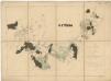
Přehledová mapa panství Štěkeň
1 : 29177


Mapa rybníků 1


Podrobné mapy zemí Koruny české v měřítku 1:75.000 a mapa vzdáleností všech míst při silnici ležících - Písek - Protivín. Průvodce statisticko-historický po všech místech na těchto mapách uvedených a rejstřík věcný názvů hor, potoků, řek, rybníků atd. Sešit 25. List 45,
1 : 75000
Podrobné mapy zemí Koruny české v měřítku 1:75.000 a mapa vzdáleností všech míst při silnici ležících - Písek - Protivín. Průvodce statisticko-historický po všech místech na těchto mapách uvedených a rejstřík věcný názvů hor, potoků, řek, rybníků atd. Sešit 25. List 45,
1 : 75000
Podrobné mapy zemí Koruny české v měřítku 1:75.000 a mapy vzdáleností všech míst při silnici ležících
1 : 75000 Netolice (Prachatice, Česko : oblast) Bělohlav, Josef F. Topič
Podrobné mapy zemí Koruny české v měřítku 1:75.000 a mapy vzdáleností všech míst při silnici ležících
1 : 75000 Protivín (Česko : oblast) Bělohlav, Josef F. Topič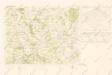
Mapy plánování ČSR

III. vojenské mapování 4352
1 : 75000