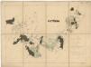
Maps of Čejetice
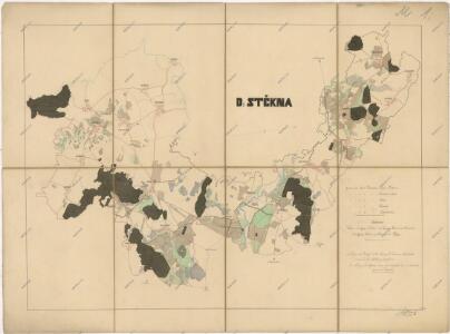
Přehledová mapa panství Štěkeň
1 : 29177

Gradkartenblatt
1 : 25000 Strakonice-oblast (Česko) Albrecht, Julius
III. vojenské mapování 4352/1
1 : 25000
[Gradkartenblatt]
1 : 25000 Volyně-oblast (Česko) Vojenský zeměpisný ústav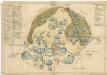
Mapa lesů a rybníků na statku Kestřany 1

Gradkartenblatt
1 : 25000 Radomyšl-oblast (Česko) Albrecht, Julius
III. vojenské mapování 4252/3
1 : 25000
Přehledová mapa pozemků části velkostatku Štěkeň
1 : 25302
III. vojenské mapování 4252/3
1 : 25000
Porostní mapa polesí Štěkeň
1 : 10000
Plán pozemků dvora Rovná
1 : 7985
Porostní mapa revíru Štěkeň a Rovná
1 : 11520
Kestrzan (Kestřan) - c3095-2-005 - Kaiserpflichtexemplar der Landkarten des stabilen Katasters
1 : 2880
Kestrzan (Kestřan) - c3095-2-002 - Kaiserpflichtexemplar der Landkarten des stabilen Katasters
1 : 2880
Kestrzan (Kestřan) - c3095-2-006 - Kaiserpflichtexemplar der Landkarten des stabilen Katasters
1 : 2880
Kestrzan (Kestřan) - c3095-2-003 - Kaiserpflichtexemplar der Landkarten des stabilen Katasters
1 : 2880
Kestrzan (Kestřan) - c3095-2-001 - Kaiserpflichtexemplar der Landkarten des stabilen Katasters
1 : 2880
Kestrzan (Kestřan) - c3095-2-004 - Kaiserpflichtexemplar der Landkarten des stabilen Katasters
1 : 2880
Kestrzan (Kestřan) - c3095-2-007 - Kaiserpflichtexemplar der Landkarten des stabilen Katasters
1 : 2880
Plán revíru Kváskovice
1 : 7985
Czehnitz (Čehnic) - c0735-1-004 - Kaiserpflichtexemplar der Landkarten des stabilen Katasters
1 : 2880
Czehnitz (Čehnic) - c0735-1-007 - Kaiserpflichtexemplar der Landkarten des stabilen Katasters
1 : 2880
Czehnitz (Čehnic) - c0735-1-006 - Kaiserpflichtexemplar der Landkarten des stabilen Katasters
1 : 2880
Czehnitz (Čehnic) - c0735-1-005 - Kaiserpflichtexemplar der Landkarten des stabilen Katasters
1 : 2880
Czehnitz (Čehnic) - c0735-1-001 - Kaiserpflichtexemplar der Landkarten des stabilen Katasters
1 : 2880
Czehnitz (Čehnic) - c0735-1-002 - Kaiserpflichtexemplar der Landkarten des stabilen Katasters
1 : 2880
Czehnitz (Čehnic) - c0735-1-003 - Kaiserpflichtexemplar der Landkarten des stabilen Katasters
1 : 2880
Záměrná mapa k porostní mapě revíru Mladějovice
1 : 5760
Nepodrzitz (Nepodrzice) - c5037-1-001 - Kaiserpflichtexemplar der Landkarten des stabilen Katasters
1 : 2880
Nepodrzitz (Nepodrzice) - c5037-1-005 - Kaiserpflichtexemplar der Landkarten des stabilen Katasters
1 : 2880
Nepodrzitz (Nepodrzice) - c5037-1-006 - Kaiserpflichtexemplar der Landkarten des stabilen Katasters
1 : 2880
Nepodrzitz (Nepodrzice) - c5037-1-004 - Kaiserpflichtexemplar der Landkarten des stabilen Katasters
1 : 2880
Nepodrzitz (Nepodrzice) - c5037-1-003 - Kaiserpflichtexemplar der Landkarten des stabilen Katasters
1 : 2880