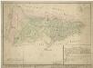
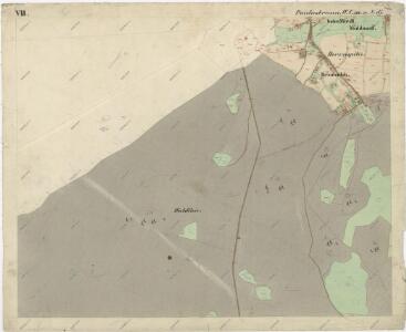
Maps of Bärnau

Katastrální mapa obce Pavlův Studenec WC-XVI-19 df
1 : 2880
Situační plán pozemků katastrální obce Pavlův Studenec
1 : 2880
Hospodářská mapa polesí Pavlův Studenec
1 : 11520
Lesní hospodářská mapa revíru Pavlův Studenec
1 : 5835
Porostní mapa revíru Pavlův Studenec
1 : 11520
Záměrná mapa parcel obce Pavlův Studenec
1 : 2880
Hospodářská mapa revíru Pavlův Studenec
1 : 5760
Mapa česko-bavorské hranice v prostoru sporného území mezi panstvím Tachov a bavorským městem Bärnau
1 : 12842
Porostní mapa revíru Zlatý Potok
1 : 11520
Porostní mapa lesního statku Ostrůvek
1 : 11520
Paulusbrunn - c5672-1-006 - Kaiserpflichtexemplar der Landkarten des stabilen Katasters
1 : 2880
Paulusbrunn - c5672-1-008 - Kaiserpflichtexemplar der Landkarten des stabilen Katasters
1 : 2880
Paulusbrunn - c5672-1-010 - Kaiserpflichtexemplar der Landkarten des stabilen Katasters
1 : 2880
Paulusbrunn - c5672-1-014 - Kaiserpflichtexemplar der Landkarten des stabilen Katasters
1 : 2880
Paulusbrunn - c5672-1-009 - Kaiserpflichtexemplar der Landkarten des stabilen Katasters
1 : 2880
Paulusbrunn - c5672-1-013 - Kaiserpflichtexemplar der Landkarten des stabilen Katasters
1 : 2880
Paulusbrunn - c5672-1-007 - Kaiserpflichtexemplar der Landkarten des stabilen Katasters
1 : 2880
Paulusbrunn - c5672-1-002 - Kaiserpflichtexemplar der Landkarten des stabilen Katasters
1 : 2880
Paulusbrunn - c5672-1-012 - Kaiserpflichtexemplar der Landkarten des stabilen Katasters
1 : 2880
Paulusbrunn - c5672-1-001 - Kaiserpflichtexemplar der Landkarten des stabilen Katasters
1 : 2880
Paulusbrunn - c5672-1-004 - Kaiserpflichtexemplar der Landkarten des stabilen Katasters
1 : 2880
Paulusbrunn - c5672-1-017 - Kaiserpflichtexemplar der Landkarten des stabilen Katasters
1 : 2880
Paulusbrunn - c5672-1-003 - Kaiserpflichtexemplar der Landkarten des stabilen Katasters
1 : 2880
Paulusbrunn - c5672-1-011 - Kaiserpflichtexemplar der Landkarten des stabilen Katasters
1 : 2880
Paulusbrunn - c5672-1-005 - Kaiserpflichtexemplar der Landkarten des stabilen Katasters
1 : 2880
Paulusbrunn - c5672-1-015 - Kaiserpflichtexemplar der Landkarten des stabilen Katasters
1 : 2880
Paulusbrunn - c5672-1-016 - Kaiserpflichtexemplar der Landkarten des stabilen Katasters
1 : 2880
Hospodářská lesní mapa panství Tachov - část Obora

Meßtischblatt 149 : Flossenbürg, 1936
1 : 250000 Flossenbürg. - Aufn. 1923, Ausg. 1926, Nachtr. 1936. - 1:25000. - München: Topograph. Zweigstelle d. Bayer. Landes, 1936. - 1 Kt.