Maps of Bärnau
Mapa česko-bavorské hranice v prostoru sporného území mezi panstvím Tachov a bavorským soudním okresem Bärnau
1 : 12842
Gradkartenblatt
1 : 25000 Čechy (Česko) Bulla, Eduard
Paulusbrunn - c5672-1-006 - Kaiserpflichtexemplar der Landkarten des stabilen Katasters
1 : 2880
Paulusbrunn - c5672-1-008 - Kaiserpflichtexemplar der Landkarten des stabilen Katasters
1 : 2880
Paulusbrunn - c5672-1-010 - Kaiserpflichtexemplar der Landkarten des stabilen Katasters
1 : 2880
Paulusbrunn - c5672-1-014 - Kaiserpflichtexemplar der Landkarten des stabilen Katasters
1 : 2880
Paulusbrunn - c5672-1-009 - Kaiserpflichtexemplar der Landkarten des stabilen Katasters
1 : 2880
Paulusbrunn - c5672-1-013 - Kaiserpflichtexemplar der Landkarten des stabilen Katasters
1 : 2880
Paulusbrunn - c5672-1-007 - Kaiserpflichtexemplar der Landkarten des stabilen Katasters
1 : 2880
Paulusbrunn - c5672-1-002 - Kaiserpflichtexemplar der Landkarten des stabilen Katasters
1 : 2880
Paulusbrunn - c5672-1-012 - Kaiserpflichtexemplar der Landkarten des stabilen Katasters
1 : 2880
Paulusbrunn - c5672-1-001 - Kaiserpflichtexemplar der Landkarten des stabilen Katasters
1 : 2880
Paulusbrunn - c5672-1-004 - Kaiserpflichtexemplar der Landkarten des stabilen Katasters
1 : 2880
Paulusbrunn - c5672-1-017 - Kaiserpflichtexemplar der Landkarten des stabilen Katasters
1 : 2880
Paulusbrunn - c5672-1-003 - Kaiserpflichtexemplar der Landkarten des stabilen Katasters
1 : 2880
Paulusbrunn - c5672-1-011 - Kaiserpflichtexemplar der Landkarten des stabilen Katasters
1 : 2880
Paulusbrunn - c5672-1-005 - Kaiserpflichtexemplar der Landkarten des stabilen Katasters
1 : 2880
Paulusbrunn - c5672-1-015 - Kaiserpflichtexemplar der Landkarten des stabilen Katasters
1 : 2880
Paulusbrunn - c5672-1-016 - Kaiserpflichtexemplar der Landkarten des stabilen Katasters
1 : 2880
Mapa česko-bavorské hranice v prostoru sporného území mezi panstvím Tachov a bavorským městem Bärnau
1 : 12842
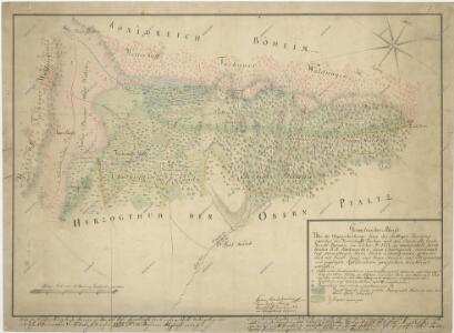
Hospodářská lesní mapa panství Tachov - část Obora

Lesní hospodářská mapa revíru Pavlův Studenec
1 : 5835
Porostní mapa revíru Pavlův Studenec
1 : 11520
Porostní mapa lesního statku Ostrůvek
1 : 11520
Porostní mapa revíru Obora
1 : 11671
Porostní mapa revíru Obora
1 : 11520
Porostní mapa revíru Zlatý Potok
1 : 11520
Záměrná mapa parcel obce Pavlův Studenec
1 : 2880
Katastrální mapa obce Pavlův Studenec WC-XVII-20 ah
1 : 2880