Maps of Horní Bělá
Hospodářská mapa části polesí Kostelík
1 : 2880
Katastrální mapa obce Radějov
1 : 2880
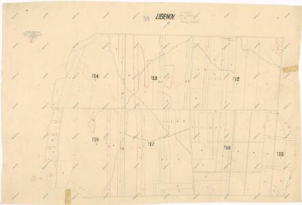
Katastrální mapa obce Líté
1 : 2880
Katastrální mapa obce Radějov
1 : 2880
Katastrální mapa obce Hubenov
1 : 2880
Porostní mapa polesí Hůrky
1 : 10000
Rading (Radegow) - c6333-1-006 - Kaiserpflichtexemplar der Landkarten des stabilen Katasters
1 : 2880
Rading (Radegow) - c6333-1-005 - Kaiserpflichtexemplar der Landkarten des stabilen Katasters
1 : 2880
Rading (Radegow) - c6333-1-002 - Kaiserpflichtexemplar der Landkarten des stabilen Katasters
1 : 2880
Rading (Radegow) - c6333-1-007 - Kaiserpflichtexemplar der Landkarten des stabilen Katasters
1 : 2880
Rading (Radegow) - c6333-1-003 - Kaiserpflichtexemplar der Landkarten des stabilen Katasters
1 : 2880
Rading (Radegow) - c6333-1-008 - Kaiserpflichtexemplar der Landkarten des stabilen Katasters
1 : 2880
Rading (Radegow) - c6333-1-001 - Kaiserpflichtexemplar der Landkarten des stabilen Katasters
1 : 2880
Rading (Radegow) - c6333-1-004 - Kaiserpflichtexemplar der Landkarten des stabilen Katasters
1 : 2880
Hubenow - c2408-1-005 - Kaiserpflichtexemplar der Landkarten des stabilen Katasters
1 : 2880
Hubenow - c2408-1-003 - Kaiserpflichtexemplar der Landkarten des stabilen Katasters
1 : 2880
Hubenow - c2408-1-002 - Kaiserpflichtexemplar der Landkarten des stabilen Katasters
1 : 2880
Hubenow - c2408-1-006 - Kaiserpflichtexemplar der Landkarten des stabilen Katasters
1 : 2880
Hubenow - c2408-1-004 - Kaiserpflichtexemplar der Landkarten des stabilen Katasters
1 : 2880
Hubenow - c2408-1-001 - Kaiserpflichtexemplar der Landkarten des stabilen Katasters
1 : 2880
Littau (Litty) - c4153-1-001 - Kaiserpflichtexemplar der Landkarten des stabilen Katasters
1 : 2880
Littau (Litty) - c4153-1-002 - Kaiserpflichtexemplar der Landkarten des stabilen Katasters
1 : 2880
Littau (Litty) - c4153-1-004 - Kaiserpflichtexemplar der Landkarten des stabilen Katasters
1 : 2880
Littau (Litty) - c4153-1-003 - Kaiserpflichtexemplar der Landkarten des stabilen Katasters
1 : 2880
Porostní mapa polesí Lipí
1 : 5760
Forst-Handkarte von der zur. k. k. Religionsfondsherrschaft Plasz gehoerigen Hurkauer Rewier
1 : 11400 Plasy-oblast (Česko) Wiehl Johann Wiehl, Andreas
Foslau (Hwozdo) - c2447-1-003 - Kaiserpflichtexemplar der Landkarten des stabilen Katasters
1 : 2880
Foslau (Hwozdo) - c2447-1-002 - Kaiserpflichtexemplar der Landkarten des stabilen Katasters
1 : 2880
Foslau (Hwozdo) - c2447-1-001 - Kaiserpflichtexemplar der Landkarten des stabilen Katasters
1 : 2880