Maps of Líté

Katastrální mapa obce Hubenov
1 : 2880
Katastrální mapa obce Líté
1 : 2880
Hubenow - c2408-1-005 - Kaiserpflichtexemplar der Landkarten des stabilen Katasters
1 : 2880
Hubenow - c2408-1-003 - Kaiserpflichtexemplar der Landkarten des stabilen Katasters
1 : 2880
Hubenow - c2408-1-002 - Kaiserpflichtexemplar der Landkarten des stabilen Katasters
1 : 2880
Hubenow - c2408-1-006 - Kaiserpflichtexemplar der Landkarten des stabilen Katasters
1 : 2880
Hubenow - c2408-1-004 - Kaiserpflichtexemplar der Landkarten des stabilen Katasters
1 : 2880
Hubenow - c2408-1-001 - Kaiserpflichtexemplar der Landkarten des stabilen Katasters
1 : 2880
Porostní mapa polesí Hůrky
1 : 10000
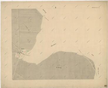
Littau (Litty) - c4153-1-001 - Kaiserpflichtexemplar der Landkarten des stabilen Katasters
1 : 2880
Littau (Litty) - c4153-1-002 - Kaiserpflichtexemplar der Landkarten des stabilen Katasters
1 : 2880
Littau (Litty) - c4153-1-004 - Kaiserpflichtexemplar der Landkarten des stabilen Katasters
1 : 2880
Littau (Litty) - c4153-1-003 - Kaiserpflichtexemplar der Landkarten des stabilen Katasters
1 : 2880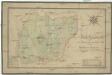
Forst-Handkarte von der zur. k. k. Religionsfondsherrschaft Plasz gehoerigen Hurkauer Rewier
1 : 11400 Plasy-oblast (Česko) Wiehl Johann Wiehl, Andreas
Hospodářská mapa části polesí Kostelík
1 : 2880
III. vojenské mapování 4050/2
1 : 25000
[Kartenblatt]
1 : 25000 Dolní Bělá (Česko : oblast) Reichsamt für Landesaufnahme
Gradkartenblatt
1 : 25000 Manětín-oblast (Česko) Brzesina, Julius von

Přehledná mapa velkostatku Manětín podle stavu k roku 1905
1 : 37500

Situační plán hájoven náležejících k panství Plasy
1 : 25000
III. vojenské mapování 4050
1 : 75000
Město Teplá
1 : 75000 Teplá (Cheb, Česko : oblast) Vojenský zeměpisný ústav
Město Teplá
1 : 75000 Teplá-oblast (Cheb, Česko) Vojenský zeměpisný ústav
Tepl und Tuschkau
1 : 75000 Město Touškov (Česko : oblast) Bloschitz, Rudolf K. u. k. Militärgeographisches Institut
Tepl und Tuschkau
1 : 75000 Město Touškov-oblast (Česko) K. u. k. Militärgeographisches Institut
Teplá
1 : 75000 Bezdružice (Česko : oblast) Vojenský zeměpisný ústav
Kralovice a okolí
1 : 75000 Kralovice (Plzeň-sever, Česko : oblast) Vojenský zeměpisný ústav