Maps of Kaznějov
Porostní mapa části kaznějovského polesí - Puchýř
1 : 2918
Záměrná mapa polesí Doubrava
1 : 5000
Katastrální mapa obce Kaznějov WC-VIII-18 ah
1 : 2880
Katastrální mapa obce Kaznějov WC-VIII-18 ag
1 : 2880
Katastrální mapa obce Kaznějov WC-VIII-18 ag
1 : 2880
Nebrzezin (Nebřezin) - c4982-1-001 - Kaiserpflichtexemplar der Landkarten des stabilen Katasters
1 : 2880
Nebrzezin (Nebřezin) - c4982-1-003 - Kaiserpflichtexemplar der Landkarten des stabilen Katasters
1 : 2880
Nebrzezin (Nebřezin) - c4982-1-002 - Kaiserpflichtexemplar der Landkarten des stabilen Katasters
1 : 2880
Katastrální mapa obce Nebřeziny
1 : 2880
Katastrální mapa obce Obora
1 : 2880
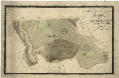
Mapa polesí Doubrava
1 : 5000
Porostní mapa polesí Plasy
1 : 2918
Kasniau (Kaznow) - c3075-1-001 - Kaiserpflichtexemplar der Landkarten des stabilen Katasters
1 : 2880
Kasniau (Kaznow) - c3075-1-006 - Kaiserpflichtexemplar der Landkarten des stabilen Katasters
1 : 2880
Kasniau (Kaznow) - c3075-1-009 - Kaiserpflichtexemplar der Landkarten des stabilen Katasters
1 : 2880
Kasniau (Kaznow) - c3075-1-002 - Kaiserpflichtexemplar der Landkarten des stabilen Katasters
1 : 2880
Kasniau (Kaznow) - c3075-1-003 - Kaiserpflichtexemplar der Landkarten des stabilen Katasters
1 : 2880
Kasniau (Kaznow) - c3075-1-007 - Kaiserpflichtexemplar der Landkarten des stabilen Katasters
1 : 2880
Kasniau (Kaznow) - c3075-1-004 - Kaiserpflichtexemplar der Landkarten des stabilen Katasters
1 : 2880
Kasniau (Kaznow) - c3075-1-005 - Kaiserpflichtexemplar der Landkarten des stabilen Katasters
1 : 2880
Kasniau (Kaznow) - c3075-1-008 - Kaiserpflichtexemplar der Landkarten des stabilen Katasters
1 : 2880
Wobora - c5347-1-007 - Kaiserpflichtexemplar der Landkarten des stabilen Katasters
1 : 2880
Wobora - c5347-1-006 - Kaiserpflichtexemplar der Landkarten des stabilen Katasters
1 : 2880
Wobora - c5347-1-004 - Kaiserpflichtexemplar der Landkarten des stabilen Katasters
1 : 2880
Wobora - c5347-1-003 - Kaiserpflichtexemplar der Landkarten des stabilen Katasters
1 : 2880
Wobora - c5347-1-005 - Kaiserpflichtexemplar der Landkarten des stabilen Katasters
1 : 2880
Wobora - c5347-1-002 - Kaiserpflichtexemplar der Landkarten des stabilen Katasters
1 : 2880
Wobora - c5347-1-001 - Kaiserpflichtexemplar der Landkarten des stabilen Katasters
1 : 2880
Mapa části polesí Plasy
1 : 5000