Maps of Chodský Újezd

Hospodářská mapa revíru Žďár
1 : 5747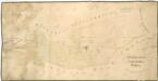
Hospodářská mapa revíru Žďár
1 : 4350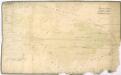
Hospodářská mapa revíru Žďár
1 : 4350
Mapa polesí Žďár
1 : 2880
Katastrální mapa obce Štokov
1 : 2880
Katastrální mapa obce Horní Výšina
1 : 2880
Katastrální mapa obce Horní Výšina
1 : 2880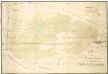
Hospodářská mapa revíru Žďár
1 : 4350
Brand - c9362-1-005 - Kaiserpflichtexemplar der Landkarten des stabilen Katasters
1 : 2880
Brand - c9362-1-006 - Kaiserpflichtexemplar der Landkarten des stabilen Katasters
1 : 2880
Brand - c9362-1-004 - Kaiserpflichtexemplar der Landkarten des stabilen Katasters
1 : 2880
Brand - c9362-1-002 - Kaiserpflichtexemplar der Landkarten des stabilen Katasters
1 : 2880
Brand - c9362-1-003 - Kaiserpflichtexemplar der Landkarten des stabilen Katasters
1 : 2880
Brand - c9362-1-007 - Kaiserpflichtexemplar der Landkarten des stabilen Katasters
1 : 2880
Brand - c9362-1-001 - Kaiserpflichtexemplar der Landkarten des stabilen Katasters
1 : 2880
Brand - c9362-1-008 - Kaiserpflichtexemplar der Landkarten des stabilen Katasters
1 : 2880
Brand - c9362-1-009 - Kaiserpflichtexemplar der Landkarten des stabilen Katasters
1 : 2880
Hals - c1762-1-004 - Kaiserpflichtexemplar der Landkarten des stabilen Katasters
1 : 2880
Hals - c1762-1-003 - Kaiserpflichtexemplar der Landkarten des stabilen Katasters
1 : 2880
Hals - c1762-1-001 - Kaiserpflichtexemplar der Landkarten des stabilen Katasters
1 : 2880
Hals - c1762-1-005 - Kaiserpflichtexemplar der Landkarten des stabilen Katasters
1 : 2880
Hals - c1762-1-002 - Kaiserpflichtexemplar der Landkarten des stabilen Katasters
1 : 2880
Stockau - c7802-1-004 - Kaiserpflichtexemplar der Landkarten des stabilen Katasters
1 : 2880
Stockau - c7802-1-001 - Kaiserpflichtexemplar der Landkarten des stabilen Katasters
1 : 2880
Stockau - c7802-1-005 - Kaiserpflichtexemplar der Landkarten des stabilen Katasters
1 : 2880
Stockau - c7802-1-003 - Kaiserpflichtexemplar der Landkarten des stabilen Katasters
1 : 2880
Stockau - c7802-1-002 - Kaiserpflichtexemplar der Landkarten des stabilen Katasters
1 : 2880
Hospodářská a porostní mapa revíru Plánská Huť
1 : 2880
Lesní přehledová mapa velkostatku Tachov
1 : 20173


