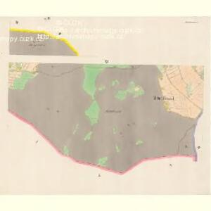
Maps of Chodský Újezd

Brand - c9362-1-005 - Kaiserpflichtexemplar der Landkarten des stabilen Katasters
1 : 2880
Brand - c9362-1-006 - Kaiserpflichtexemplar der Landkarten des stabilen Katasters
1 : 2880
Brand - c9362-1-004 - Kaiserpflichtexemplar der Landkarten des stabilen Katasters
1 : 2880
Brand - c9362-1-002 - Kaiserpflichtexemplar der Landkarten des stabilen Katasters
1 : 2880
Brand - c9362-1-003 - Kaiserpflichtexemplar der Landkarten des stabilen Katasters
1 : 2880
Brand - c9362-1-007 - Kaiserpflichtexemplar der Landkarten des stabilen Katasters
1 : 2880
Brand - c9362-1-001 - Kaiserpflichtexemplar der Landkarten des stabilen Katasters
1 : 2880
Brand - c9362-1-008 - Kaiserpflichtexemplar der Landkarten des stabilen Katasters
1 : 2880
Brand - c9362-1-009 - Kaiserpflichtexemplar der Landkarten des stabilen Katasters
1 : 2880
Hospodářská mapa revíru Žďár
1 : 5747
Hospodářská mapa revíru Žďár
1 : 4350
Mapa polesí Žďár
1 : 2880
Hospodářská a porostní mapa revíru Plánská Huť
1 : 2880
Hospodářská mapa revíru Žďár
1 : 4350
Hospodářská mapa revíru Žďár
1 : 4350
Katastrální mapa obce Horní Výšina
1 : 2880
Katastrální mapa obce Horní Výšina
1 : 2880
Katastrální mapa obce Horní Výšina
1 : 2880
Porostní mapa revíru Horní Výšina
1 : 11500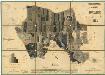
Porostní mapa revíru Horní Výšina
1 : 11520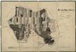
Porostní mapa revíru Horní Výšina
1 : 11451
Ringlberg - c2176-2-003 - Kaiserpflichtexemplar der Landkarten des stabilen Katasters
1 : 2880
Ringlberg - c2176-2-001 - Kaiserpflichtexemplar der Landkarten des stabilen Katasters
1 : 2880
Ringlberg - c2176-2-006 - Kaiserpflichtexemplar der Landkarten des stabilen Katasters
1 : 2880
Ringlberg - c2176-2-002 - Kaiserpflichtexemplar der Landkarten des stabilen Katasters
1 : 2880
Ringlberg - c2176-2-005 - Kaiserpflichtexemplar der Landkarten des stabilen Katasters
1 : 2880
Ringlberg - c2176-2-007 - Kaiserpflichtexemplar der Landkarten des stabilen Katasters
1 : 2880
Ringlberg - c2176-2-004 - Kaiserpflichtexemplar der Landkarten des stabilen Katasters
1 : 2880
Prommenhof - c0527-1-002 - Kaiserpflichtexemplar der Landkarten des stabilen Katasters
1 : 2880
Prommenhof - c0527-1-004 - Kaiserpflichtexemplar der Landkarten des stabilen Katasters
1 : 2880
Prommenhof - c0527-1-006 - Kaiserpflichtexemplar der Landkarten des stabilen Katasters
1 : 2880
Prommenhof - c0527-1-003 - Kaiserpflichtexemplar der Landkarten des stabilen Katasters
1 : 2880
Prommenhof - c0527-1-001 - Kaiserpflichtexemplar der Landkarten des stabilen Katasters
1 : 2880