Maps of Meerbeck

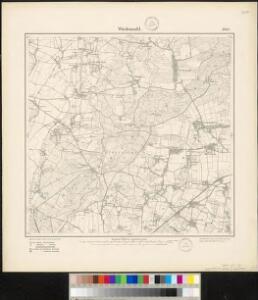
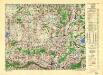
Meßtischblatt 1950 : Wiedensahl, 1898
1 : 250000 Wiedensahl. - Aufn. 1896. - 1:25000. - [Berlin]: Reichsamt für Landesaufnahme, 1898. - 1 Kt.
Plan de la Bataille de Tonhausen
1 : 100000 Mollova mapová sbírka Bauer, Friedrich Wilhelm von Schley, Jacobus van der Hondt, Pierre de
Composite: 285. Minden.
1 : 100000 Reichsamt fur Landesaufnahme
285. Minden.
1 : 100000 Reichsamt fur Landesaufnahme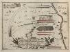
Bataille welche der Herzog Ferdinand über die Franzosische Haupt-Armee ohnweit Minden d. 1. August 1759 mit Ruhm erfochten
1 : 100000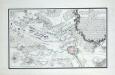
Plan der Battaille bey Minden zwischen der Französ. Armee unter Commando des Mr. des Contades und der Alliirten Armee commandirt von Sr. Durchl. den Herzog Ferdinand von Braunschweig den 1ten Augustus 1759

Plan de la bataille de Tonhausen
Germany/Central Europe 1:100,000, Minden
Germany / Central Europe 1:100,000, Series GSGS 4416. Great Britain. War Office. [London] : Ordnance Survey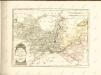

Episcopatus Hildesiensis Descriptio Novissima [Karte], in: Novus Atlas, das ist, Weltbeschreibung, Bd. 1, S. 108.
1 Karte aus Atlas Blaeu, Joan Blaeu, Willem Janszoon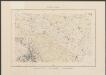
Episcopatus Hildesiensis Descriptio Novissima [Karte], in: Theatrum orbis terrarum, sive, Atlas novus, Bd. 1, S. 194.
1 Karte aus Atlas Blaeu, Joan Blaeu, Willem Janszoon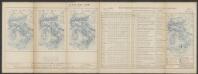
Episcopatus Hildesiensis Descriptio Novissima [Karte], in: Le théâtre du monde, ou, Nouvel atlas contenant les chartes et descriptions de tous les païs de la terre, Bd. 1, S. 137.
1 Karte aus Atlas Blaeu, Willem Janszoon und Blaeu, Joan Blaeu, Willem Janszoon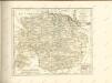

Carta Delli Dvcati di Brvnsvvic, e Lvnebvrg con le loro ad herenze Vescounti, Contee, e Dominy
1 : 370000 Mollova mapová sbírka Hacque, Johann Baptist Hacque, Johann Baptist
DUCATUS BRUNSVICENSIS FEREQUE LUNAEBURGENSIS
1 : 370000 Braunschweig (Německo) Visscher, Claes Jansz. C.I. Visscher excudit
Die Fürstenthümer Grubenhagen, Calenberg, Wolfenbütel und Blankenburg, welche den südlichen Theil der chur- und fürstl. braunschweig-lüneburgi[schen] Reichsländer begreifen
1 Karte : Kupferdruck ; 46 x 57 cm Güssefeld bey denen Homænnischen Erben
Die Fürstenthümer Grubenhagen, Calenberg, Wolfenbütel und Blankenburg, welche den südlichen Theil der chur- und fürstl. braunschweig-lüneburgi[schen] Reichsländer begreifen
1 Karte : Kupferdruck ; 46 x 57 cm Güssefeld bey denen Homænnischen Erben
Geographische Lage der südlichen Braunschweigischen Reichsgebiete darinnen
1 : 280000 Mollova mapová sbírka Homann, Johann Baptist Homann, Johann Baptista - dědici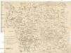
Carta delli dvcati di Brvnsvvic, e Lvnebvrg
1 : 368000 Braunschweig (Německo : historické území)
Ducatus Brunsuicensis
1 : 400000 Braunschweig (Německo : historické území) Homann, Johann Baptist Ioh. Bapt. Homanni
Carte Du Théatre De La Guerre Présente En Westphaliae Avec Les Pays Voisins
1 : 290000 Mollova mapová sbírka Rizzi Zannoni, Giovanni Antonio Back, Jakob Conrad Broenner, Heinrich Ludwig
Ducatus Brunsuicensis in Eiusdem tres Principatus Calenbergicum Scilicet et Grubenhagensem
1 : 360000 Mollova mapová sbírka Wit, Frederik de Covens, Johannes I
Ducatus Brunsuicensis in Eiusdem tres Principatus Calenbergicum Scilicet et Grubenhagensem
1 : 380000 Mollova mapová sbírka Schenk, Pieter Schenk, Peter I
Ducatus Brunsuicensis Episcopatus Hildesiensis Principatus Halberstadiensis Tabula
1 : 370000 Mollova mapová sbírka Danckerts, Justus Danckerts, Justus
Ducatus Brunsuicensis juxta tres suos Principatus Calenbergic. nimir. et Grubenhagens.
1 : 385000 Mollova mapová sbírka Seutter, Matthäus Seutter, Matthäus
Ducatus Brunsuicensis in tres suos Principatus Calenbergicum sc. Grubenhag & Guelpherbitanum distincte divisi, nec non Episcopatus Hildesiensis, Pr. Halber. Comitatus Schauenburgici, aliorumq; confiniorum exacta Tabula
1 : 380000 Mollova mapová sbírka Homann, Johann Baptist Homann, Johann Baptista
Ducatus Brunsuicensis
1 : 375000 Mollova mapová sbírka Homann, Johann Baptist Homann, Johann Baptista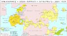
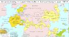
Braunschweig, Lippe-Detmold, Schaumburg-Lippe 1820
Staat Braunschweig, Lippe-Detmold Kunz, Andreas ; Moeschl, Joachim Robert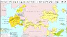
Braunschweig, Lippe-Detmold, Schaumburg-Lippe 1848
Staat Braunschweig, Lippe-Detmold Kunz, Andreas ; Moeschl, Joachim Robert