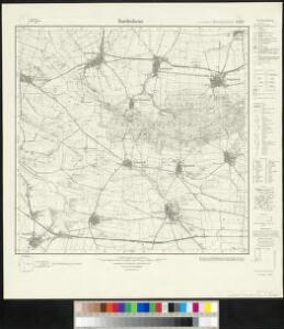
Maps of Aspenstedt

Meßtischblatt 2233 : Dardesheim, 1934
1 : 250000 Dardesheim. - Hrsg. 1904, einz. Nachtr. 1934. - 1:25000. - [Berlin]: Reichsamt für Landesaufnahme, 1934. - 1 Kt.
Meßtischblatt 2233 : Dardesheim, 1904
1 : 250000 Dardesheim. - Aufn. 1902. - 1:25000. - [Berlin]: Reichsamt für Landesaufnahme, 1904. - 1 Kt.
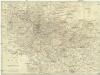
Meßtischblatt 188 : Dingelstedt, 1870
1 : 250000 Dingelstedt. - Aufn. 1857. - 1:25000. - [Berlin]: Reichsamt für Landesaufnahme, 1870. - 1 Kt.
337. Halberstadt.
1 : 100000 Reichsamt fur Landesaufnahme
Composite: 337. Halberstadt.
1 : 100000 Reichsamt fur Landesaufnahme
Principatus Halberstadiensis Abbat: Quedlinburgens cum Comitatu Wernigerodano
1 : 180000 Mollova mapová sbírka Seutter, Matthäus Lotter, Tobias Conrad Seutter, Matthäus
100. Halberstadt, uit: Topographische Uebersichtskarte des Deutschen Reiches / herausgegeben v. d. Kartogr. Abt. d. Königl. Preuß. Landesaufnahme
1 : 200000 titelvariant: Topogr. Übersichtskarte des Deutschen Reiches; Annotatie: Titel boven bladen ook: Topogr. Übersichtskarte des Deutschen Reiches; Annotatie geografische gegevens: Op elk blad twee maatstokken: 10 Kilometer = 5,5 cm; 1 geogr. Meile = 3,6 cm; Legenda onder op elk blad Königlich Preußische Landesaufnahme. Kartographische Abtheilung [S.l : Königlich Preußische Landesaufnahme, Kartographische Abtheilung]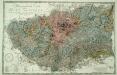
Petrographische Carte des Harz Gebirges
1 : 80000 Lasius, Georg Sigismund Otto; Tischbein, Georg Heinrich
Principatus Halberstadiensis, abbat. Quedlinburgens cum comitatu Wernigerodano, ad hodiernum verum statum ex acta prodiit
1 : 135000 Halberstadt (Německo) Seutter, Matthäus Lotter, Tobias Conrad M. Seutter
Principatus Halberstadiensis, abbat. Quedlinburgens cum comitatu Wernigerodano, ad hodiernum verum statum ex acta prodiit
1 : 135000 Halberstadt (Německo) Seutter, Matthäus Lotter, Tobias Conrad ex officina Matthaei Seutteri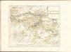
Charte vom Harz
1 : 151000 Harz (Německo) Fritsch, I. H. Wilhelm Heinrichshofen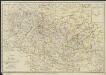
Charte vom Harz
1 : 180000 nach den neuesten astron. Bestimmungen, den besten Charten, Privatzeichnungen, und mehrern eignen Vermessungen und Berechnungen entworfen von I. H. Fritsch [...] 1804 Magdeburg : Heinrichshofen
LandtTafel des Eyszfeldts
1 : 180000 Karte des Eichsfelds Flucken, Johann ; Merian Mattäus Merianische Erben
Carté de la Principauté de Halberstadt
1 : 170000 Mollova mapová sbírka Riese, G. Hieronymus Homann, Johann Baptista - dědici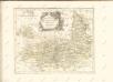

Die Herzogthümer Anhalt Dessau, Cöthen u. Bernburg
1 : 780000 Anhaltsko (Německo) Bibliographisches Institut
Episcopatus Hildesiensis nec non Vicinorum Statuum delineatio Geographica
1 : 290000 Mollova mapová sbírka Arenhold, Gerard J. Schneider, Ruprecht Adam Homann, Johann Baptista - dědici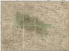
Special Charte von dem Harz-Gebirge und den umliegenden Ländern
Harz-oblast (Německo) von dem Geographischen Institute
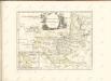
EPISCOPATVS | HALBERSTAT.
Amstlædami apud Joannem Blaeu.
Episcopatus Hildesiensis nec non vicinorum statuum delineatio geographica
1 : 287000 Hildesheim (Německo) Arenhold, Gerhard Justus Haered. Ioh. Baptist. Homanni
Episcopatus Hildesiensis nec non vicinorum statuum delineatio geographica
1 : 287000 Hildesheim (Německo) Arenhold, Gerhard Justus Haered. Ioh. Baptist. Homanni
Episcopatus Hildesiensis cum adjacentibus provinciis ac statibus mappa geographica repraesentatus
1 : 290000 Hildesheim (Německo) Seutter, Matthäus studio et impensis Matthaei Seutteri
Charte von dem Herzogthume Braunschweig
1 : 267500 Braunschweig (Německo : historické území) Streit, Friedrich Wilhelm Beyer, I. Friedrich Campe
Braunschweig Herzogthum.
1 : 425000 Gotthard, A.
Episcopatvs Halberstadensis Descriptio nova
1 : 410000 Mollova mapová sbírka Funck, David Zetter, Paul de Funck, David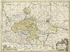
Episcopatvs Halberstadensis Descriptio nova
1 : 410000 Mollova mapová sbírka Zetter, Paul de Schenk, Peter I
Episcopatvs Halberstadensis Descriptio nova
1 : 410000 Mollova mapová sbírka Janssonius, Johannes Zetter, Paul de Janssonius, Johannes I
Straßen im Herzogtum Braunschweig 1848
Staat Braunschweig Straßennetz Kunz, Andreas ; Treiling, Thomas