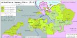
Maps of Börde

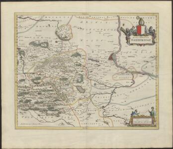
EPISCOPATVS | HALBERSTAT.
Amstlædami apud Joannem Blaeu.
Episcopatvs Halberstadensis Descriptio nova
1 : 410000 Mollova mapová sbírka Funck, David Zetter, Paul de Funck, David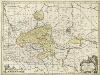
Episcopatvs Halberstadensis Descriptio nova
1 : 410000 Mollova mapová sbírka Zetter, Paul de Schenk, Peter I
Episcopatvs Halberstadensis Descriptio nova
1 : 410000 Mollova mapová sbírka Janssonius, Johannes Zetter, Paul de Janssonius, Johannes I
Episcopatus Halberstadensis Descriptio nova. [Karte], in: Novus atlas absolutissimus, Bd. 2, S. 89.
1 Karte aus Atlas Janssonius Offizin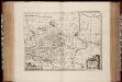
Episcopatvs Halberstadensis descriptio nova / Paullus de Zetter, fe
1 : 410000 Annotatie: Origineel is Blad 89 in atlas factice; Annotatie geografische gegevens: Schaalvermelding op kaart: 3 Milliaria Germanica communia; Nummering rechtsboven: XVIII Paullus de Zetter [Amstelodami : Ex Officina Janssonio-Waesbergiana, Mosis Pitt et Stephani Swart]
Die Herzogthümer Anhalt Dessau, Cöthen u. Bernburg
1 : 780000 Anhaltsko (Německo) Bibliographisches Institut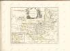

Geographische Charte des Herzogthums Magdenburg und Halle
1 : 308000 Halle an der Saale-oblast (Německo) Schenk, Pieter P. Schenk
Geographische Charte des Herzogthums Magdenburg und Halle
1 : 308000 Halle an der Saale-oblast (Německo) Schenk, Pieter P. Schenk
Geographische Charte des Herzogthums Magdenburg und Halle
1 : 308000 Halle an der Saale-oblast (Německo) Schenk, Pieter P. Schenk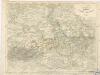
Die Herzogthümer Anhalt, Dessau, Cöthen u. Bernburg

Carté de la Principauté de Halberstadt
1 : 170000 Mollova mapová sbírka Riese, G. Hieronymus Homann, Johann Baptista - dědici
Straßen in den Anhaltischen Herzogtümern 1848
Anhalt Straßennetz Kunz, Andreas ; Treiling, Thomas
PRINCIPATVS | ANHALTINVS.
[Amsterdam : Joan Blaeu]
Anhaltinus Principatus Stirpis Ascaniensis felicitate hodiè florens
Seutter, Matthäus; Lotter, Tobias Conrad
Magdeburg 59, uit: Special-Karte von Mittel-Europa / nach amtlichen Quellen bearbeitet von W. Liebenow
1 : 300000 titelvariant: W. Liebenow's Mittel-Europa; Annotatie: Titel boven de bladen: W. Liebenow's Mittel-Europa Johannes Wilhelm Liebenow 1822-1897 Frankfurt a. M. : Ludwig Ravenstein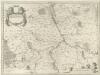
Principatvs Anhaltinvs
1 : 260000 Mollova mapová sbírka Blaeu, Joan Blaeu, Joan I.
Nova Anhaltini Principatus Tabula
1 : 230000 Schuchart, Johann Tobias; Schenk, Pieter Schenck
Aucta et Emendata Anhaltini Principatus Tabula
Schnoedt, Karl L.; Püschel, Johann Joachim
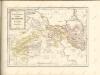
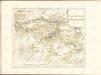

Principatus Halberstadiensis, abbat. Quedlinburgens cum comitatu Wernigerodano, ad hodiernum verum statum ex acta prodiit
1 : 135000 Halberstadt (Německo) Seutter, Matthäus Lotter, Tobias Conrad M. Seutter
Principatus Halberstadiensis, abbat. Quedlinburgens cum comitatu Wernigerodano, ad hodiernum verum statum ex acta prodiit
1 : 135000 Halberstadt (Německo) Seutter, Matthäus Lotter, Tobias Conrad ex officina Matthaei Seutteri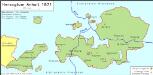
Anhaltische Herzogtümer 1871
Anhalt Kunz, Andreas ; Moeschl, Joachim Robert
Halle 73, uit: Special-Karte von Mittel-Europa / nach amtlichen Quellen bearbeitet von W. Liebenow
1 : 300000 titelvariant: W. Liebenow's Mittel-Europa; Annotatie: Titel boven de bladen: W. Liebenow's Mittel-Europa Johannes Wilhelm Liebenow 1822-1897 Frankfurt a. M. : Ludwig Ravenstein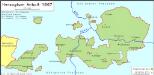
Anhaltische Herzogtümer 1867
Anhalt Kunz, Andreas ; Moeschl, Joachim Robert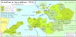
Anhaltische Herzogtümer 1814
Anhalt-Bernburg, Anhalt-Dessau Hundt, Michael